Related Research Articles

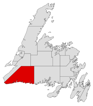
Burgeo-La Poile is a provincial electoral district for the House of Assembly of Newfoundland and Labrador, Canada. As of 2011, there are 7,527 eligible voters living within the district. The district was first created when Newfoundland joined confederation in 1949 as Burgeo and La Poile, and existed until 1975. It was recreated in 1995 following a reduction in the number of seats in the House of Assembly from 52 to 48, forming from the amalgamation of the former districts of La Poile and Burgeo-Bay D'Espoir.
St. George's Bay - informally referred to as Bay St. George due to its French translation Baie St-George - is a large bay in the province of Newfoundland and Labrador, Canada. It is located on the west coast of the island of Newfoundland and comprises a sub-basin of the Gulf of St. Lawrence. The estimated population of the entire bay is 16,000, based on the demographic data of each community.

St. George's is a Canadian community in the St. George's Bay on the southwest coast of Newfoundland of the province of Newfoundland and Labrador.

Stephenville Crossing is a town in the Canadian province of Newfoundland and Labrador. It is on the island of Newfoundland at the easternmost limit of Bay St. George.
Barachois Brook is a local service district and designated place in the Canadian province of Newfoundland and Labrador. It is on the western coast of the province, on Bay St. George, located just 5 km south of Stephenville Crossing.
Port au Port Bay located on the west coast of the Island of Newfoundland formed by a long narrow point of land of the Port au Port Peninsula and the area of Newfoundland known as the Lewis Hills, in the Canadian province of Newfoundland and Labrador.

College of the North Atlantic is one of the largest post-secondary educational and skills training centres in Atlantic Canada, with a history dating back 50 years. The college has 17 campus locations throughout the province of Newfoundland and Labrador in Canada, various partner universities in China and formerly operated a technical education college for the State of Qatar in the Middle East. The enabling legislation is the College Act.
Jeffrey's is a village located south west of Stephenville on the west coast of the island of Newfoundland, Canada. It had a population of 1,174 in 2016.

La Poile Bay is a natural bay in Newfoundland, Canada, in the southwestern area of the island, off the south coast. It subdivides into Northeast Arm and North Bay. The settlement of La Poile is located on the bay.
Rencontre Bay is natural bay on the island of Newfoundland in the province of Newfoundland and Labrador, Canada. It is near Devil Bay.
Cinq Cerf Bay is a natural bay on the island of Newfoundland in the province of Newfoundland and Labrador, Canada.
God Bay is a natural bay on the island of Newfoundland in the province of Newfoundland and Labrador, Canada. The village of Burnt Islands is located by the bay.
Isthmus Bay is a natural bay on the island of Newfoundland in the province of Newfoundland and Labrador, Canada. It is a sub-bay of St. George's Bay and flanked by the town of Port-au-Port. It is separated from Port au Port Bay by two narrow gravel isthmi.
Cape Norman Bay is a natural bay near Cape Norman, off the island of Newfoundland in the province of Newfoundland and Labrador, Canada.
Goose Bay is a natural bay off the island of Newfoundland in the province of Newfoundland and Labrador, Canada.
Blackhead Bay is a natural bay off the island of Newfoundland in the province of Newfoundland and Labrador, Canada. It is a side bay of Bonavista Bay.
Robinhood Bay is a natural bay off the island of Newfoundland in the province of Newfoundland and Labrador, Canada. It cuts into the southern shore of Bonavista Peninsula and opens into Trinity Bay. The town of Port Rexton is situated at the north end of the bay.
Caplin Bay is a natural bay on the coast of Labrador in the province of Newfoundland and Labrador, Canada.
Bay St. George South is a local service district and designated place in the Canadian province of Newfoundland and Labrador on the south coast of Bay St. George, a large bay on the west coast of the island of Newfoundland. Bay St. George South consists nine communities, namely Heatherton, Robinsons, Cartyville, McKay's, Jeffrey's, St. David's, St. Fintan's, Lock Leven en Highlands.

Division No. 1, Subdivision G is an unorganized subdivision on the Avalon Peninsula in Newfoundland and Labrador, Canada. It is in Division 1 and contains the unincorporated communities of Baccalieu Island, Besom Cove, Bradley's Cove, Burnt Point, Caplin Cove, Daniel's Cove, Grates Cove, Gull Island, Job's Cove, Kingston, Long Beach, Lower Island Cove, Low Point, Northern Bay, Ochre Pit Cove, Red Head Cove, Riverhead, Smooth Cove and Western Bay.
References
- ↑ United States Hydrographic Office; Davenport, Richard G. (1884). Newfoundland and Labrador: The coast and banks of Newfoundland and the coast of Labrador, from Grand Point to the Koksoak River, with the adjacent islands and banks (Public domain ed.). Govt. print. off. pp. 191–. Retrieved 20 November 2011.