
Larrys Creek is a 22.9-mile-long (36.9 km) tributary of the West Branch Susquehanna River in Lycoming County in the U.S. state of Pennsylvania. A part of the Chesapeake Bay drainage basin, its watershed drains 89.1 square miles (231 km2) in six townships and a borough. The creek flows south from the dissected Allegheny Plateau to the Ridge-and-valley Appalachians through sandstone, limestone, and shale from the Devonian, Mississippian, and Pennsylvanian periods.

Little Muncy Creek is the major tributary of Muncy Creek in Lycoming and Sullivan Counties, Pennsylvania, United States. Via Muncy Creek and the West Branch Susquehanna River, it is part of the Susquehanna River drainage basin and waters from it flow ultimately into the Chesapeake Bay.
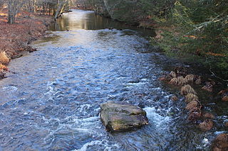
Huntington Creek is a tributary of Fishing Creek in Luzerne and Columbia counties, Pennsylvania, in the United States. It is approximately 29.5 miles (47.5 km) long.

Spruce Run is a tributary of Little Fishing Creek in Columbia County, Pennsylvania, in the United States. It is approximately 6.9 miles (11.1 km) long and flows through Madison Township. The watershed of the stream has an area of 9.80 square miles (25.4 km2). Several people settled on the stream in the 1780s and 1790s. Two bridges were built over it in the 20th century.

Shingle Run is a tributary of West Branch Run in Lycoming County and Columbia County, in Pennsylvania, in the United States. It is approximately 2.5 miles (4.0 km) long and flows through Jordan Township, Lycoming County and Pine Township, Columbia County. Its watershed has an area of 1.63 square miles (4.2 km2) and the stream has various unnamed tributaries. At least one bridge crosses the stream. The stream is inhabited by trout. It is named after nearby sawmills.

Lick Run is a tributary of Little Fishing Creek in Lycoming County and Columbia County, in Pennsylvania, in the United States. It is approximately 5.2 miles (8.4 km) long and flows through Jordan Township in Lycoming County and Pine Township, in Columbia County. The watershed of the stream has an area of 4.40 square miles (11.4 km2). The entire drainage basin is considered to be a Coldwater Fishery and a portion of the stream is considered to be Class A Wild Trout Waters. At least one bridge crosses the stream.

Wolfhouse Run is a tributary of Little Fishing Creek in Columbia County, Pennsylvania, in the United States. It is approximately 2.9 miles (4.7 km) long and flows through Pine Township. The watershed of the stream has an area of 2.03 square miles (5.3 km2). The steam is considered to be an Exceptional Value stream and a Coldwater Fishery. However, it is considered to be impaired as well. At least two bridges and one sawmill have been built over or on the stream.

Devil Hole Run is a tributary of Little Fishing Creek in Columbia County, Pennsylvania, in the United States. It is approximately 2.7 miles (4.3 km) long and flows through Pine Township. The stream is mostly surrounded by forested land and it is part of a Locally Significant Area listed on the Columbia County Natural Areas Inventory. It has a single named tributary. Plantlife common in the vicinity of the stream include hemlock trees. Trout inhabit the stream itself.

Kline Hollow Run is a tributary of Devil Hole Run in Lycoming County and Columbia County, in Pennsylvania, in the United States. It is approximately 3.6 miles (5.8 km) long and flows through Jordan Township in Lycoming County and Pine Township in Columbia County. The stream is mostly surrounded by forested land and it is part of a Locally Significant Area listed on the Columbia County Natural Areas Inventory. Plantlife common in the vicinity of the stream include hemlock trees and trout inhabit the stream itself. The stream is considered to be an Exceptional Value stream.

Little Brier Run is a tributary of Little Fishing Creek in Lycoming County and Columbia County, in Pennsylvania, in the United States. It is approximately 2.9 miles (4.7 km) and flows through Jordan Township in Lycoming County and Pine Township in Columbia County. The watershed of the stream has an area of 2.62 square miles (6.8 km2). The stream itself is inhabited by trout and is considered to be an Exceptional Value stream and a Migratory Fishery. It has one unnamed tributary. Various wetlands are present in the vicinity of the stream and its unnamed tributary.

Culley Run is a tributary of Fishing Creek in Columbia County, Pennsylvania, in the United States. It is approximately 1.4 miles (2.3 km) long and flows through Benton Township. The stream's watershed has an area of 1.45 square miles (3.8 km2). Shale, sandstone, alluvium, and glacial till can be found in the watershed. At least one bridge crosses the stream. The stream is most likely named after Alexander Colley, Sr.

Elk Run is tributary of West Branch Fishing Creek in Sullivan County and Columbia County, in Pennsylvania, in the United States. It is approximately 4.8 miles (7.7 km) long and flows through Davidson Township in Sullivan County and Sugarloaf Township in Columbia County. The watershed of the stream has an area of 7.49 square miles (19.4 km2). The stream has three named tributaries: Gallows Run, Hog Run, and Long Run. Elk Run is considered to be an Exceptional Value stream and a Migratory Fishery. The forests surrounding it are deemed by the Sullivan County Natural Areas Inventory to be a "locally significant" area. The stream is named for an elk that was killed in it in the 1840s.
Shingle Mill Run is a tributary of West Branch Fishing Creek in Sullivan County, Pennsylvania, in the United States. It is approximately 2.4 miles (3.9 km) long and flows through Davidson Township. The watershed of the stream has an area of 2.60 square miles (6.7 km2). The stream has one named tributary, Bearwallow Run. Shingle Mill Run is designated as an Exceptional Value stream and has a population of native trout. The stream has high water quality and is slightly acidic. Boulder Colluvium and bedrock consisting of sandstone and shale can be found near the stream.
Laurel Run is a tributary of West Branch Fishing Creek in Sullivan County, Pennsylvania, in the United States. It is approximately 1.2 miles (1.9 km) long and flows through Davidson Township. The stream is in the United States Geological Survey quadrangle of Elk Grove. Wisconsinan Flow-Till, Boulder Colluvium, Wisconsinan Till Moraine, alluvium, and alluvial fan occur in the vicinity of the stream, as does bedrock consisting of sandstone and shale. The southern terminus of the late Wisconsinan glaciation is also in the area. A wood plank bridge on stone masonry abutment walls crosses the stream.
Deep Hollow is a tributary of West Branch Fishing Creek in Luzerne County, Pennsylvania, in the United States. It is approximately 0.8 miles (1.3 km) long and flows through Davidson Township. The watershed of the stream has an area of 0.53 square miles (1.4 km2). Wild trout naturally reproduce in the stream. The surficial geology in the area mainly features bedrock consisting of sandstone and shale, as well as a small amount of Boulder Colluvium and alluvium.
Spencer Run is a tributary of West Creek in Columbia County, Pennsylvania, in the United States. It is approximately 2.1 miles (3.4 km) long and flows through Jackson Township and Benton Township. The watershed of the stream has an area of 2.07 square miles (5.4 km2). Wild trout naturally reproduce in the stream. The surficial geology in the area mainly features Illinoian Till, Illinoian Leg, alluvium, colluvium, and bedrock.

Shepman Run is a tributary of Little Muncy Creek in Lycoming County, Pennsylvania, in the United States. It is approximately 2.6 miles (4.2 km) long and flows through Moreland Township. The watershed of the stream has an area of 1.59 square miles (4.1 km2). A covered bridge crosses the stream. Shepman Run is classified as a Coldwater Fishery and a Migratory Fishery.
Laurel Run is a tributary of Little Muncy Creek in Columbia County and Lycoming County, in Pennsylvania, in the United States. It is approximately 6.8 miles (10.9 km) long and flows through Madison Township and Pine Township in Columbia County and Franklin Township and Moreland Township in Lycoming County. The watershed of the stream has an area of 12.2 square miles (32 km2). It is classified as a Coldwater Fishery and a Migratory Fishery. A number of bridges have been constructed over the stream.


