
Orono is a town in Penobscot County, Maine, United States. Located on the Penobscot and Stillwater rivers, it was first settled by American colonists in 1774. They named it in honor of Chief Joseph Orono, a sachem of the indigenous Penobscot nation who long occupied this territory.
Howland is a town in Penobscot County, Maine, United States, which was settled in 1818. It was named after John Howland, one of the passengers on the Mayflower. The population was 1,094 at the 2020 census.

The Kennebec River is a 170-mile-long (270 km) river within the U.S. state of Maine. It rises in Moosehead Lake in west-central Maine. The East and West Outlets join at Indian Pond and the river flows southward. Harris Station Dam, the largest hydroelectric dam in the state, was constructed near that confluence. The river is joined at The Forks by its tributary the Dead River, also called the West Branch.

The Penobscot River is a 109-mile-long (175 km) river in the U.S. state of Maine. Including the river's West Branch and South Branch increases the Penobscot's length to 264 miles (425 km), making it the second-longest river system in Maine and the longest entirely in the state. Its drainage basin contains 8,610 square miles (22,300 km2).
The Piscataquis River is a major tributary of the Penobscot River, found in Piscataquis County, Maine, United States. It starts from the confluence of its East Branch and West Branch in Blanchard. The river flows in a mostly eastern direction until it meets the Penobscot at Howland. It is approximately 65 miles (105 km) in length.

The Penobscot Narrows Bridge is a 2,120-foot-long (650 m) cable-stayed bridge that carries US 1/SR 3 over the Penobscot River. It connects Verona Island to Prospect, in the U.S. state of Maine. It opened in December 2006, replacing the Waldo–Hancock Bridge, built in 1931.

The East Branch Penobscot River is a 75.3-mile-long (121.2 km) tributary of Maine's Penobscot River. It flows in Piscataquis County and Penobscot County.
The South Branch Penobscot River is a river in Somerset County, Maine. Its source, Penobscot lake, the north end of which at is about 1,000 feet (300 m) from the Canada–United States border in Sandy Bay. This section of the border runs along the height of land separating the watersheds of the Penobscot River and the Monument River, which feeds into the Saint Lawrence River.

The Stillwater River is an 11.5-mile-long (18.5 km) side channel of the Penobscot River in Maine. From its source in Old Town, the Stillwater runs 2.3 miles (3.7 km) northwest along the northeast side of Orson Island, the site of the Penobscot Indian Reservation. It then runs 9.2 miles (14.8 km) south along the west sides of Orson and Marsh islands, over three dammed falls. The stream rejoins the main stem of the Penobscot in Orono.

The West Branch Penobscot River is a 117-mile-long (188 km) tributary of the Penobscot River through the North Maine Woods in Maine. The river is also known as Abocadneticook, Kahgognamock, and Kettegwewick.

The Great Works Dam was a dam on the Penobscot River between Old Town and Bradley in Penobscot County, Maine, USA. The original Great Works Dam was constructed in the 1830s and replaced between 1887 and 1900. The dam was originally owned by the Penobscot Chemical Fibre Company and was acquired by Diamond International Corporation in 1968 along with the adjacent mill. The dam and powerhouse were sold several more times, and in 2010 the Penobscot River Restoration Trust bought the dam from PPL Corporation based on an agreement that was signed in 2004. On June 11, 2012, deconstruction of the dam began as a part of an extensive project involving four dams to restore eleven species of sea-run fish to the Penobscot River.
The Veazie Dam was a hydroelectric dam on the Penobscot River between Veazie and Eddington in Penobscot County, Maine. In 2010 the Penobscot River Restoration Trust bought the dam from PPL Corporation based on an agreement that was signed in 2004. Deconstruction of the dam began on July 22, 2013 as a part of an extensive project involving four dams to restore eleven species of sea-run fish to the Penobscot River. The Veazie Dam was the furthest downstream of the dams on the Penobscot River; now the Milford and Orono Dam dams are furthest downstream, albeit on separate side of Marsh Island. The Great Works Dam, which was 8 mi (13 km) upstream of the Veazie Dam, was removed in 2012.
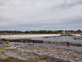
The Milford Dam is a dam on the Penobscot River between Old Town and Milford in Penobscot County, Maine. The dam will receive a new fish lift as a part of an extensive project involving four dams to restore eleven species of sea-run fish to the Penobscot River. The Great Works Dam was removed in 2012 and was just downstream of the Milford Dam. The dam's power plant has an 8 MW installed capacity.

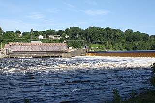
The Howland Dam is a hydroelectric dam on the Piscataquis River at its confluence with the Penobscot River in Howland, Penobscot County, Maine, USA. The Howland Dam was purchased by the Penobscot River Restoration Trust in 2010 from PPL Corporation, formerly Pennsylvania Power and Light, under an agreement reached several years earlier. A fish bypass was constructed around the dam in 2015.
The Stillwater Dam is a hydroelectric dam on the Stillwater River in Old Town north of downtown Orono in Penobscot County, Maine. As a part of the Penobscot River restoration and the removal of the Great Works and Veazie dams, the Stillwater Dam and the Orono Dam will be upgraded to maintain previous levels of power generation.
The Orono Dam is a hydroelectric dam on the Stillwater River at its confluence with the Penobscot River in Orono, Penobscot County, Maine. As a part of the Penobscot River restoration and the removal of the Great Works and Veazie dams, the Orono Dam and Stillwater Dam will be upgraded to maintain previous levels of power generation.

Ripogenus Gorge is a rock-walled canyon formed where the West Branch Penobscot River crosses the Caribou Lake anticline. Ripogenus Falls controlled discharge from Ripogenus Lake until Ripogenus Dam was completed at the upstream end of the gorge in 1916. The dam forms a hydroelectric reservoir raising the level of Ripogenus Lake to include the upstream Chesuncook Lake, Caribou Lake, and Moose Pond. The resulting reservoir is often identified by the name of the largest included lake: Chesuncook. The gorge provides an unusual exposure of Maine North Woods bedrock typically covered by saturated glacial till. The Silurian Ripogenus Formation of weakly metamorphosed shallow marine siliciclastics and fossiliferous limestone has been described from investigation of the gorge.

The Natural Resources Council of Maine (NRCM) is a Maine-based, 501(c)(3) non-profit organization, with offices in Augusta, Maine. Founded in 1959 as a small, volunteer-based environmental advocacy group, NRCM has grown to be Maine's largest environmental advocacy organization, with more than 25,000 supporters and activists and a staff of 28, including science and policy experts.

State Route 155 (SR 155) is a 34.3-mile-long (55.2 km) state highway in the U.S. state of Maine. It runs in a southwesterly-northeasterly direction mostly in Penobscot County. It connects the town of Bradford at SR 11 and SR 221 with Lincoln at U.S. Route 2 (US 2) and SR 6.
