Bel Air or Bel-Air may refer to:

Minot State University is a public university in Minot, North Dakota. Founded in 1913 as a normal school, Minot State University is the third-largest university in North Dakota, offering undergraduate and graduate degree programs.

Quentin Northrup Burdick was an American lawyer and politician. A member of the Democratic Party, he represented North Dakota in the U.S. House of Representatives (1959–1960) and the U.S. Senate (1960–1992). At the time of his death, he was the third longest-serving senator among current members of the Senate.

The North Dakota State Fair is an annual state fair held each July in Minot, North Dakota, USA. The fair has carnival rides, agricultural expositions, government and commercial exhibitions, and a variety of musical and performance entertainment.
The Minot Park District is the unit of the Minot, North Dakota municipal government responsible for maintaining city parks. The District is managed by a board of five directors elected by city voters to four year terms.
Roosevelt Park is a park in Minot, North Dakota operated by the Minot Park District. It is the largest park in the city of Minot. The park is named after Theodore Roosevelt, former president of the United States, who is honoured by a large statue in the middle of the park.

Usher Lloyd Burdick was a member of the United States House of Representatives from North Dakota. He was the father of Quentin N. Burdick.
The geography of Minot, North Dakota is treated extensively in this article.

Tagus is a ghost town in Mountrail County, North Dakota, United States. The town was founded in 1900 approximately forty miles west of Minot and along the Great Northern Railway's transcontinental route. It incorporated in 1908 and reached a peak population of 140 in 1940. It was originally named Wallace, but was later renamed Tagus to avoid confusion with the town of Wallace, Idaho.
Sigdal House is an historic Norwegian log home which was relocated to Minot, North Dakota.
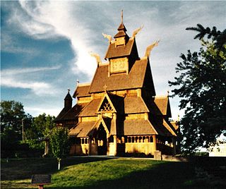
Scandinavian Heritage Park is a park located in the Upper Brooklyn neighborhood of Minot, North Dakota. Scandinavian Heritage Park features remembrances and replicas from each of the Scandinavian countries: Norway, Sweden and Denmark, as well as Finland and Iceland. The park was established during 1988 to celebrate and preserve Scandinavian heritage. The first building was dedicated October 9, 1990.

Corbett Field, formerly known as the Minot Municipal Ballpark, is a baseball park located south of the Roosevelt Park Zoo in Minot, North Dakota. The park was built between 1935 and 1937 through the Federal Emergency Relief Administration. It was designed by Minot architect Ira Rush. In 1947, the Minot Park Board began improvements on the park, including a roof on the grandstand and field lights. The namesake of the park, Victor A. Corbett, was a local dentist, who served as the president of the Park Board during that time. The orange seats that were later added to the grandstands were purchased from the old Fulton County Stadium.

Downtown Minot is the central business district of Minot, North Dakota, located south of the Souris River in the Souris Valley. Downtown is the site of the first permanent settlement in Minot in 1886. Downtown is home to many of Minot's cultural sites of interest. It is also home to numerous galleries, stores and restaurants. The Minot Riverwalk traverses the downtown.

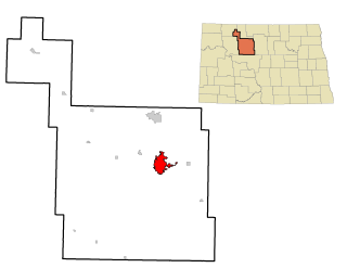
Bel Air is a neighborhood in Minot, North Dakota, located in the Souris River Valley. It is roughly bound by North Hill to the north, Sixteenth Street NW to the east, Fourth Avenue NW to the south and the city limits on the west. The neighborhood was home to about a thousand people in 2010. The neighborhood is home to Bel Air Elementary School on Twenty Fifth Street NW. The neighborhood was developed as the Bel Air Addition in 1956. Fourth Avenue is home to a number of businesses in Bel Air, many of which were severely damaged in the Souris River flood in 2011. Bel Air is home to the Church of the Living God, the Bible Fellowship Church and the Christ Lutheran Church.

South Hill is a neighborhood in Minot, North Dakota, located south of the Souris River, above the Souris River Valley. It is a primarily residential neighborhood, although there are commercial zones along South Broadway, Twentieth Avenue South and around the Dakota Square Mall.
Upper Brooklyn or Brooklyn Heights is a neighborhood on South Hill in Minot, North Dakota. The neighborhood consists of the sections of the Brooklyn Addition that are not part of Downtown Minot. The High Third neighborhood, the Lower Brooklyn neighborhood and the area around the Minot Municipal Auditorium, which were part of the Brooklyn Addition, are considered part of the downtown area. Upper Brooklyn is bordered by downtown and the BNSF railroad tracks to the north, Minot High School's Magic City Campus to the west, Eleventh Avenue SW to the south and South Broadway and Lower Brooklyn to the east. The neighborhood is approximately 0.46 square kilometers. The neighborhood is home to the Scandinavian Heritage Park and Jim Hill Middle School.
West Oaks is a neighborhood in Minot, North Dakota. The neighborhood is bounded by Oak Park to the North, the Souris River to the east, the Soo Line Railroad tracks to the south and Sixteenth Street SW. The neighborhood is home to the West Oaks Animal Hospital, the West Oaks Apartments, Harleys Automotive Center and gas station, Eagles Wings Community Fellowship and a number of single family homes. Oak Park's south entrance is located in the neighborhood on Oak Drive SW. A thin strip of land between the Oak Park Oxbow and the Souris River connects the park with the neighborhood. The neighborhood was greatly impacted by the Souris River flood in 2011. In June 2011, the Washington Post printed a story about the Minot flood on the front page with an accompanying photograph of Harleys and the nearby Arrowhead Mall. Water inundated both structures, despite the large dikes constructed around both buildings. On June 26, 2011, the New York Times also printed an article with an aerial photograph of the flooded Harleys. Similar aerial photographs of the flood at that location are displayed at the Harleys gas station.
Polaris Park is a park and surrounding residential neighborhood on North Hill in Minot, North Dakota. The neighborhood is roughly bounded by 30th Ave NW, Frontage Road, 24th Ave NW and 8th St NW. The park, which is owned by the Minot Park District, is home to a 9-hole disc golf course, an outdoor ice rink, a skatepark, tennis courts, a picnic shelter and a baseball field. The Polaris Park neighborhood is home to a number of single family homes and apartment complexes north and east of the park. Adjacent to the park is the St. Alexius Clinic, which is affiliated with St. Alexius Medical Center in Bismarck. Frontage Road in Polaris Park is home to a few businesses, including MLT Vacations, North Hill's second largest employer.