
The Yentna River is a river in South Central Alaska, formed by its East Fork and West Fork at 62°16′50″N151°46′26″W, flows South-East to Susitna River, 30 miles (48 km) North-West of Anchorage, Alaska; Cook Inlet Low.

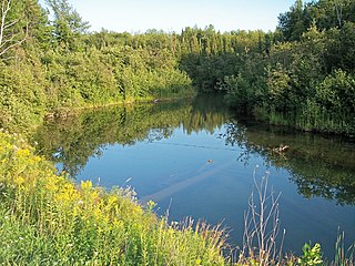
Pine River may refer to any of the following streams in the U.S. state of Michigan:
- Pine River. The main branch forms with the confluence of the East and West Branches of the Pine River at 44°29′38″N83°23′16″W in Alcona County. The South Branch joins approximately 1.5 miles (2.4 km) to the south and flows into Iosco County, where it empties into Van Etten Lake at 44°29′38″N83°23′16″W northwest of Oscoda.
- Pine River. The main branch is formed by the confluence of the North and Middle Branches northeast of Standish and flows into the Saginaw Bay of Lake Huron at 43°58′32″N83°51′16″W. The South Branch Pine River joins the main stream at 43°59′08″N83°53′17″W.
- Pine River is a short waterway, which along with Round Lake, connects Lake Charlevoix with Lake Michigan at Charlevoix.
- Pine River rises in Chippewa County and flows south through Mackinac County into the St. Martin Bay of Lake Huron at 46°03′09″N84°39′22″W The North Pine River, also known as the North Branch Pine River, joins at 46°12′20″N84°36′17″W. Another tributary, Hemlock Creek, is also known as Pine River.
- Pine River, also known as the South Branch Manistee River, rises in southeast Wexford County, flows southwest across northwest Osceola County, then west and north through the northeast corner of Lake County and back into southwest Wexford County, emptying into the Tippy Dam Pond on the Manistee River at 44°13′37″N85°54′27″W. The main stream is formed from the confluence of the East Branch Pine River with the North Branch Pine River at 44°06′02″N85°31′40″W. Another tributary, the Spaulding Creek, is also known as the Little Pine River
- Pine River, in Marquette County, is a very short stream draining Pine Lake into Lake Superior at 46°53′27″N87°52′13″W, north of the Huron Mountains.
- Pine River rises in from Pine Lake in eastern Mecosta County, flows mostly south and east through Isabella County, then south along eastern edge of Montcalm County, then east and north through Gratiot County and Midland County, emptying into the Chippewa River at 43°36′06″N84°17′33″W, just about two miles before it joins the Tittabawassee River near Midland. The South Branch Pine River joins the main stream at 43°30′37″N85°00′02″W Another tributary, Miller Creek, is also sometimes known as Pine River or the West Branch Pine River. The North Branch Pine River joins the main stream at 43°26′03″N84°50′18″W.
- Pine River empties into the St. Clair River at 42°49′13″N82°29′08″W on the south side of St. Clair. The South Branch Pine River joins the main stream at 42°58′11″N82°37′10″W. Another tributary, Quakenbush Drain, is also sometimes known as Pine River.
- Pine Creek empties into Lake Superior and is also known as the Pine River.
Firesteel River is an 18.3-mile-long (29.5 km) river in Ontonagon County on the Upper Peninsula of the U.S. state of Michigan. The river flows generally northwest between the Flintsteel River and the West Sleeping River and empties into Lake Superior. Branches of the river are identified as the West Branch and East Branch, and the river receives Black Creek about three miles north of the junction of the two main branches.
The Mineral River is an 18.7-mile-long (30.1 km) tributary of Lake Superior on the western Upper Peninsula of Michigan in the United States. It flows for its entire length in western Ontonagon County, rising in the Ottawa National Forest and flowing generally northward to meet Lake Superior about 11 miles (18 km) west-southwest of Ontonagon. The United States Board on Geographic Names settled on "Mineral River" as the stream's name in 1976; according to the Geographic Names Information System it has also been known historically as "Beaver Creek".

The Presque Isle River runs 42.1 miles (67.8 km) through the Upper Peninsula of Michigan and empties into Lake Superior. Along its course, it flows through the Ottawa National Forest and Porcupine Mountains Wilderness State Park. It has 300 square miles (780 km2) of drainage area in Upper Michigan and northern Wisconsin.
The Whitefish River is an 11.9-mile-long (19.2 km) river on the Upper Peninsula of the U.S. state of Michigan. The mouth of the river is in Delta County at 45°54′34″N86°58′01″W on the Little Bay De Noc of Lake Michigan. The main branch of the river is formed by the confluence of the east and west branches at 46°03′25″N86°52′17″W.

Caseyville Township is located in St. Clair County, Illinois, United States. As of the 2010 census, its population was 31,996 and it contained 14,054 housing units.
Rock Run is a tributary stream of the Potomac River in Montgomery County, Maryland. The headwaters of the stream rise in the village of Potomac, and the creek flows southeast for 5.3 miles (8.5 km) to the Potomac River.
Nelson Township is a civil township in Barnes County, North Dakota, USA. As of the 2000 census, its population was 61.
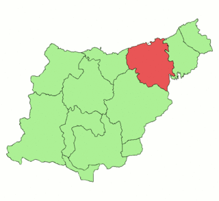
Donostialdea is one of the eight regions of Gipuzkoa, Basque Autonomous Community, corresponding to the basin of the lower Urumea along with a strip of basin corresponding to the Oria River, the region borrowing its name after the capital city of Gipuzkoa Donostia-San Sebastian, in Spain. The region comprises eleven municipalities extending in an area of 305.72 km2. It borders in the east with the region or subcomarca of Oarsoaldea, on the south with Leitzaldea or Norte de Aralar in Spanish (Navarre), on the west with Urola Kosta and on the north with the Bay of Biscay.
Cara Sucia River is a river of El Salvador. It arises in the foothills of the Parque Nacional El Imposible and flows westward through the area of Cara Sucia in the Ahuachapán Department region to a bay near El Zapote.
The East Sleeping River is a 21.3-mile-long (34.3 km) river in Ontonagon County, Michigan, in the United States. It is a tributary of Lake Superior.
The Pelton River is a 5.9-mile-long (9.5 km) tributary of the Slate River in Gogebic County on the Upper Peninsula of Michigan in the United States. Via the Slate River, its water flows to Lake Gogebic, which feeds the West Branch Ontonagon River, flowing to the Ontonagon River and ultimately to Lake Superior.
The Peshekee River is a 31.1-mile-long (50.1 km) river on the Upper Peninsula of Michigan in the United States. It is a tributary of Lake Michigamme, and its waters flow via the Michigamme River and the Menominee River to Lake Michigan.

Wagner is a hamlet in northern Alberta, Canada within the Municipal District of Lesser Slave River No. 124. It is located 0.5 kilometres (0.3 mi) north of Highway 2, approximately 223 kilometres (139 mi) northwest of Edmonton. It has an elevation of 585 m (1,919 ft).
The Little Black River is a 19.6-mile-long (31.5 km) stream in Gogebic County in the U.S. state of Michigan. It rises in Bessemer Township at 46°21′23″N89°53′09″W} and flows mostly north to Sunday Lake in Wakefield, then westward for approximately a mile before emptying into the Black River at 46°29′18″N89°59′49″W, just north of Ramsay. The water is approximately 14 inches (360 mm) deep.

Indian River is a 59.1-mile-long (95.1 km) tributary of the Manistique River on the Upper Peninsula of Michigan in the United States. It rises out of Hovey Lake at 46°17′36″N86°42′20″W on Hiawatha National Forest land in Alger County and flows south and east through a lake district and on through Schoolcraft County. The river flows into the 8,659 acre (35 km²) Indian Lake at 46°17′36″N86°42′20″W and flows out at 45°59′30″N86°17′15″W. It then flows east and south about 2.5 miles where it merges with the Manistique River, which then flows through Manistique and into Lake Michigan at 45°56′56″N86°14′45″W.
Floodwood River is an 11.0-mile-long (17.7 km) river in Ontonagon County in the U.S. state of Michigan.
Carp River is a 10.3-mile-long (16.6 km) river in Gogebic and Ontonagon counties in the U.S. state of Michigan. The Carp River is formed by the outflow of the Lake of the Clouds at 46°48′04″N89°45′38″W in the Porcupine Mountains of the Upper Peninsula.
Little Carp River is a 15-mile-long (24 km) river in Gogebic and Ontonagon counties in the U.S. state of Michigan. The Carp River rises at 46°45′54″N89°44′44″W in the Porcupine Mountains of the Upper Peninsula.


