
Ewenny Priory, in Ewenny in the Vale of Glamorgan, Wales, was a monastery of the Benedictine order, founded in the 12th century. The priory was unusual in having extensive military-style defences and in its state of preservation; the architectural historian John Newman described it as “the most complete and impressive Norman ecclesiastical building in Glamorgan”. Following the Dissolution of the Monasteries, parts of the priory were converted into a private house by Sir Edward Carne, a lawyer and diplomat. This Elizabethan house was demolished between 1803 and 1805 and replaced by a Georgian mansion, Ewenny Priory House. The house is still owned by the Turbervill family, descendants of Sir Edward. The priory is not open to the public apart from the Church of St Michael, the western part of the priory building, which continues to serve as the parish church for the village. The priory is in the care of Cadw and is a Grade I listed building.

Penally is a coastal village, parish and community 1 mile (1.6 km) southwest of Tenby in Pembrokeshire, Wales. The village is known for its Celtic Cross, Penally Abbey, the neighbouring St. Deiniol's Well, WWI Practice trenches, and Penally Training Camp.

This is a list of Grade I-listed buildings in the county of Pembrokeshire, Wales.
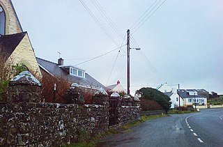
Penycwm is a small settlement on the A487 road near Newgale, Pembrokeshire, Wales. It is part of the community of Brawdy. At the other end of a valley to the coast is Penycwm beach, also known as Pwll March. Penycwm is close to the popular Newgale Sands, on the Pembrokeshire Coast Path and in the Pembrokeshire Coast National Park.

Prendergast is a former village and parish in Pembrokeshire, Wales, now a suburb of Haverfordwest, Pembrokeshire's county town. The name survives as an electoral ward of Haverfordwest. The Western Cleddau forms the parish's western boundary, and the Hiog, a tributary of the Cleddau, the eastern boundary.

Rudbaxton Rath is a ring-shaped enclosure together with a ringed keep in the parish of Rudbaxton, Pembrokeshire, Wales. It is situated roughly 1.54 km northeast of Crundale and about 2.39 km east of Haverfordwest Aerodrome.

Brynberian is a small village in north Pembrokeshire, Wales, in the foothills of the Preseli Mountains in the Pembrokeshire Coast National Park. It is in the community of Eglwyswrw and the parish of Nevern, and is on the B4329 road between Crosswell and Tafarn y Bwlch. Afon Brynberian flows through the village under an ancient bridge and joins the River Nevern to the north.
Manorowen is a small settlement and parish on the A487 2 miles (3.2 km) southwest of Fishguard, Pembrokeshire, West Wales, in the Community of Scleddau; the parish includes the village of Scleddau—the eastern part of which is in the neighbouring parish of Llanstinan. A listed property bears the name of the parish, and the church is dedicated to St Mary.

Glandwr is a small rural village in the parish of Llanfyrnach and the community of Crymych, Pembrokeshire, Wales. The village appears on a pre-1850 parish map as Glan-dwr. It is linked by unclassified roads to adjacent settlements and to the A478 road.

St Brides Castle is a 19th-century castellated baronial-style mansion in the parish of St Brides and the community of Marloes and St Brides, Pembrokeshire, southwest Wales.

Carswell Medieval House is a Grade II*-listed historic stone ruin of a medieval tenant farm in the village of Penally, near St Florence in Tenby. Visit Wales describe it as "one of the only buildings of its type still standing in this part of Wales" and an example of "everyday medieval life away from the grand castles often associated with the period."

William Owen (1791–1879) was a Welsh architect working in Haverfordwest in the late Georgian and early Victorian periods. He built up a considerable practice in Pembrokeshire and Carmathenshire. He was the county surveyor of Pembrokeshire, four times Mayor of Haverfordwest and High Sheriff of Pembrokeshire in 1859.

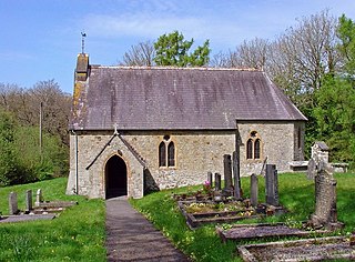
The Church of St Michael and All Angels, Castlemartin, Pembrokeshire, Wales is a redundant church dating from the 13th century. A Grade I listed building, the church is now in the care of the Friends of Friendless Churches.
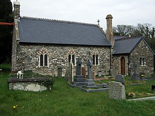
The Church of St Dogfael, Meline, Pembrokeshire, Wales is a redundant church dating from the 19th century. A Grade II listed building, the church is now in the care of the Friends of Friendless Churches.

Alban Square, in the centre of Aberaeron, Ceredigion, Wales is a range of early 19th century townhouses. The town of Aberaeron was developed around 1810 as a port by the Rev. Alban Thomas Jones Gwynne, a local landowner. After his father's death in 1819, Colonel A.T.J. Gwynne engaged Edward Haycock Sr. to plan a major expansion. Leases were sold in the early 1830s and Alban Square was designed, but largely unbuilt, by 1834. The town grew as a centre for shipbuilding and commerce. The expansion of the railways, and their arrival in Aberaeron in 1909 brought these commercial endeavours to an end and the town became a seaside resort and a centre for local government. No.s 9-20 inclusive on Alban Square are Grade II* listed buildings, their Cadw listing records describing the square as "a well preserved terrace in a key location".

Portland Place, in the centre of Aberaeron, Ceredigion, Wales is a terrace of mid-19th century townhouses. The town of Aberaeron was developed around 1810 as a port by the Rev. Alban Thomas Jones Gwynne, a local landowner. After his father's death in 1819, Colonel A.T.J. Gwynne engaged Edward Haycock Sr. to plan a major expansion. Leases were sold in the early 1830s and development continued for much of the rest of the 19th century, the town growing as a centre for shipbuilding and commerce. The expansion of the railways, and their arrival in Aberaeron in 1909 brought these commercial endeavours to an end and the town became a seaside resort and a centre for local government. No.s 1-7 inclusive on Portland Place are Grade II* listed buildings, forming "the finest single terrace" in Aberaeron.

Laura Place, in the centre of Aberystwyth, Ceredigion, Wales is a terrace of mid-19th century townhouses. Pevsner considers them "the finest Georgian houses of the town". Laura Place forms two sides of a square, fronting the Church of St Michael and All Angels in the shadow of Aberystwyth Castle. It was developed in the early 19th century by William Edward Powell of Nanteos, High Sheriff and Lord Lieutenant of Cardiganshire. Powell's architect is uncertain, but Cadw suggests George Stanley Repton as a possibility. Repton was certainly the architect of the Assembly Rooms, a separate building standing between 1-9 and 11-12.

St Michael's Church is a parish church in the town of Aberystwyth, Ceredigion, Wales. St Michael's is the fourth church to stand on the site. The first dated from the 15th century but was in ruins by the mid-18th century. Its replacement only stood for some forty years before itself being replaced in 1829-1833 with a church designed by Edward Haycock Sr. of Shrewsbury. Nothing of the two earlier buildings remains. The Haycock church was itself superseded by the present church, built by Nicholson & Son of Hereford in 1886-1890. A fragment of the Haycock church remains to the west of the current building.

Porth-Mawr is a gatehouse on Brecon Street in the centre of Crickhowell, Powys, Wales. Constructed in the 15th century by a branch of the Herbert family as the entrance to their Tudor mansion of Cwrt Carw, it is a Grade I listed building.
Whitewell Ruins is a historic site on the edge of the village of Penally, Pembrokeshire, Wales. The site consists of three structures, called A, B and C. The purposes of the structures are not fully understood, although sources agree that the largest, Whitewell Ruins: Structure A, was a medieval manor house and that Structures B and C served as ancillary buildings of some type. All three structures are Grade I listed buildings and the site is a Scheduled monument.
