Related Research Articles

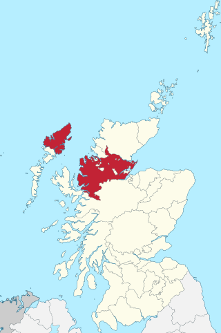
Ross and Cromarty, also referred to as Ross-shire and Cromartyshire, is a variously defined area in the Highlands and Islands of Scotland. There is a registration county and a lieutenancy area in current use, the latter of which is 8,019 square kilometres in extent. Historically there has also been a constituency of the Parliament of the United Kingdom, a local government county, a district of the Highland local government region and a management area of the Highland Council. The local government county is now divided between two local government areas: the Highland area and Na h-Eileanan Siar. Ross and Cromarty border Sutherland to the north and Inverness-shire to the south.
Ross is a region of Scotland. One of the provinces of Scotland from the 9th century, it gave its name to a later earldom and to the counties of Ross-shire and, later, Ross and Cromarty. The name Ross allegedly derives from a Gaelic word meaning "headland", perhaps a reference to the Black Isle. Another possible origin is the West Norse word for Orkney – Hrossey – meaning horse island; the area once belonged to the Norwegian earldom of Orkney. Ross is a historical comital region, perhaps predating the Mormaerdom of Ross. It is also a region used by the Kirk, with the Presbytery of Ross being part of the Synod of Ross, Sutherland and Caithness.

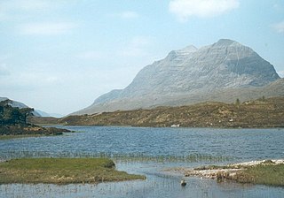
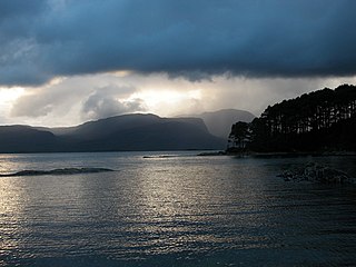
Loch Maree is a loch in Wester Ross in the Northwest Highlands of Scotland. At 21.7 km (13.46 mi) long and with a maximum width of four kilometres, it is the fourth-largest freshwater loch in Scotland; it is the largest north of Loch Ness. Its surface area is 28.7 km2 (11.08 sq mi).
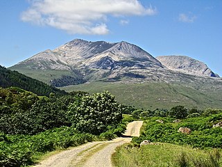
Beinn Eighe is a mountain massif in the Torridon area of Wester Ross in the Northwest Highlands of Scotland. Lying south of Loch Maree, it forms a long ridge with many spurs and summits, two of which are classified as Munros: Ruadh-stac Mòr at 1,010 m (3,314 ft) and Spidean Coire nan Clach at 993 m (3,258 ft). Unlike most other hills in the area it has a cap of Cambrian basal quartzite which gives the peaks of Beinn Eighe a distinctive light colour. Its complex topography has made it popular with both hillwalkers and climbers and the national nature reserve on its northern side makes it an accessible mountain for all visitors.

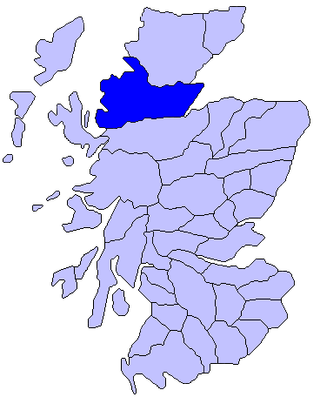
Wester Ross is an area of the Northwest Highlands of Scotland in the council area of Highland. The area is loosely defined, and has never been used as a formal administrative region in its own right, but is generally regarded as lying to the west of the main watershed of Ross, thus forming the western half of the county of Ross and Cromarty. The southwesternmost part of Ross and Cromarty, Lochalsh, is not considered part of Wester Ross by the local tourist organisation, Visit Wester Ross, but is included within the definition used for the Wester Ross Biosphere Reserve.

Applecross is a peninsula north-west of Kyle of Lochalsh in the council area of Highland, Scotland. The name Applecross is at least 1,300 years old and is not used locally to refer to the 19th century village with the Applecross Inn, lying on the Applecross Bay, facing the Inner Sound, on the opposite side of which lies the Inner Hebridean island of Raasay. The monastery of Applecross was established by St Maelrubha, in the 7th century. A sculptured stone is the only remaining relic of Maelrubha, who built a chapel there. The Applecross peninsula is a peninsula in Wester Ross, Highland, on the north west coast of Scotland.
Kinlochewe is a village in Wester Ross in the Northwest Highlands of Scotland. It is in the parish of Gairloch, the community of Torridon and Kinlochewe and the Highland council area. It lies near the head of Loch Maree in its magnificent valley, and serves as a junction between the main Ullapool road north, and that which heads west to the coast at Loch Torridon. Loch Maree was at one time also known as Loch Ewe, hence the village's apparently confused name.
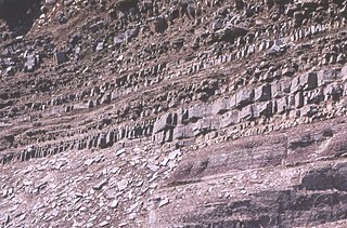
In geology, the term Torridonian is the informal name for the Torridonian Group, a series of Mesoproterozoic to Neoproterozoic arenaceous and argillaceous sedimentary rocks, which occur extensively in the Northwest Highlands of Scotland. The strata of the Torridonian Group are particularly well exposed in the district of upper Loch Torridon, a circumstance which suggested the name Torridon Sandstone, first applied to these rocks by James Nicol. Stratigraphically, they lie unconformably on gneisses of the Lewisian complex and their outcrop extent is restricted to the Hebridean Terrane.

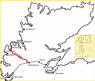
Achnasheen railway station is a remote railway station on the Kyle of Lochalsh Line, serving the village of Achnasheen in the north of Scotland. The station is 27 miles 72 chains (44.9 km) from Dingwall, between Achanalt and Achnashellach. ScotRail, who manage the station, operate all services.
Ross-shire is a historic county in the Scottish Highlands. The county borders Sutherland to the north and Inverness-shire to the south, as well as having a complex border with Cromartyshire – a county consisting of numerous enclaves or exclaves scattered throughout Ross-shire's territory. Ross-shire includes most of Ross along with Lewis in the Outer Hebrides. Dingwall is the traditional county town. The area of Ross-shire is based on that of the historic province of Ross, but with the exclusion of the many enclaves that form Cromartyshire.
The Northwest Highlands are located in the northern third of Scotland that is separated from the Grampian Mountains by the Great Glen. The region comprises Wester Ross, Assynt, Sutherland and part of Caithness. The Caledonian Canal, which extends from Loch Linnhe in the south-west, via Loch Ness to the Moray Firth in the north-east splits this area from the rest of the country. The city of Inverness and the town of Fort William serve as gateways to the region from the south.
Loch Carron is a sea loch on the west coast of Ross and Cromarty in the Scottish Highlands, which separates the Lochalsh peninsula from the Applecross peninsula, and from the Stomeferry headland east of Loch Kishorn. It is the point at which the River Carron enters the North Atlantic Ocean.

Ardheslaig is a crofting settlement at the northern end of the Applecross peninsula in the Scottish Highlands. It is 3 miles (4.8 km) north-west of Shieldaig on the shores of Loch Torridon. It is described as a "widely dispersed group of houses around the head of an inlet" to the loch and has no shops or local services.

The A832 is a road in the Scottish Highlands, linking Cromarty, on the east coast, to Gairloch on the west coast, and beyond Gairloch to Braemore Junction. It is 126 miles (203 km) long and runs entirely in the former county of Ross and Cromarty. The road forms part of the Wester Ross Coastal Trail.

Loch Ewe is a sea loch in the region of Wester Ross in the Northwest Highlands of Scotland. The shores are inhabited by a traditionally Gàidhlig-speaking people living in or sustained by crofting villages, the most notable of which, situated on the north-eastern shore, is the Aultbea settlement.

Diabaig is a remote coastal fishing and crofting township in Wester Ross, in the Northwest Highlands of Scotland. Diabaig lies on the north shore of the sea loch of Loch Diabaig, an inlet off the north side of Loch Torridon, and is in the Highland council area.
Leod Macgilleandrais is purported to have been a 14th-century Scotsman, who lived in the north-west of Scotland. He is known from clan traditions, which date to the late 17th century. According to these traditions, Leod was a follower of the Earl of Ross, and that he was an enemy of the Mackenzies of Kintail. He is said to have captured one of the early Mackenzie chiefs, and was then later killed by the slain chief's son sometime in the 14th century. His memory is preserved in the place where he is said to have been slain. According to at least one version of the tradition, Leod was survived by a son named Paul. Several historians in 19th and early 20th centuries equated this son to Paul Mactire.

Loch na h-Oidhche is a remote freshwater loch lying between Loch Torridon and Loch Maree in the Flowerdale Forest, Wester Ross, Scotland. It is approximately 4.5 mi (7.2 km) north of the small village of Torridon and 8 mi (13 km) southeast of Gairloch.
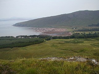
Applecross Bay is large remote tidal coastal embayment, located next to the small fishing village of Applecross and is on the west coast of the Applecross peninsula in the Wester Ross part of Ross and Cromarty, in the Scottish Highlands in the west coast of Scotland. It lies between Loch Torridon and Loch Kishorn. The bay and village was inaccessible by road until the late 18th century and can now be reached by the long coastal road Shieldaig that was completed in 1982, or from the Scottish Gaelic: Bealach na Bà or Pass of the Cattle which at 625 metres (2,051 ft), is one of the highest roads in Scotland. The village of Applecross was established by St. Moalrubha, in the 7th century. A sculptured stone is the only relic of St. Moalrubha remaining, who built a chapel there.
The Loch Maree and Aultbea Railway was one of several branch railway-lines proposed for the North-West Highlands of Scotland in the early 1890s. Although a full survey was conducted in 1892 and a Private Bill was submitted to the Westminster Parliament on 18 November 1892, the necessary Act to permit construction did not receive approval and the plan was dropped.
References
- ↑ "Sutherland Highlands Tourist Information Assynt Wester Ross Coast Scotland". Archived from the original on 18 June 2008. Retrieved 23 April 2010.