
The Harz, also called the Harz Mountains, is a highland area in northern Germany. It has the highest elevations for that region, and its rugged terrain extends across parts of Lower Saxony, Saxony-Anhalt, and Thuringia. The name Harz derives from the Middle High German word Hardt or Hart. The name Hercynia derives from a Celtic name and could refer to other mountain forests, but has also been applied to the geology of the Harz. The Brocken is the highest summit in the Harz with an elevation of 1,141.1 metres (3,744 ft) above sea level. The Wurmberg is the highest peak located entirely within the state of Lower Saxony.
Harz National Park is a nature reserve in the German federal states of Lower Saxony and Saxony-Anhalt. It comprises portions of the western Harz mountain range, extending from Herzberg and Bad Lauterberg at the southern edge to Bad Harzburg and Ilsenburg on the northern slopes. 95% of the area is covered with forests, mainly with spruce and beech woods, including several bogs, granite rocks and creeks. The park is part of the Natura 2000 network of the European Union.
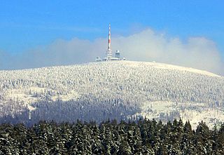
The Brocken, also sometimes referred to as the Blocksberg, is the highest peak in the Harz mountain range and also the highest peak in Northern Germany; it is near Schierke in the German state of Saxony-Anhalt between the rivers Weser and Elbe. Although its elevation of 1,141 metres (3,743 ft) is below alpine dimensions, its microclimate resembles that of mountains of about 2,000 m (6,600 ft). The peak above the tree line tends to have a snow cover from September to May, and mists and fogs shroud it up to 300 days of the year. The mean annual temperature is only 2.9 °C (37.2 °F). It is the easternmost mountain in northern Germany; travelling east in a straight line, the next prominent elevation would be in the Ural Mountains in Russia.

Thale is a town in the Harz district in Saxony-Anhalt in central Germany. Located at the steep northeastern rim of the Harz mountain range, it is known for the scenic Bode Gorge stretching above the town centre.
Osterode am Harz, often simply called Osterode, is a town in south-eastern Lower Saxony in central Germany on the south-western edge of the Harz mountains. It was the seat of government of the district of Osterode. Osterode is located on the German Timber-Frame Road.

Herzberg am Harz is a town in the Göttingen district of Lower Saxony, Germany.

Blankenburg (Harz) is a town and health resort in the district of Harz in Saxony-Anhalt, Germany, at the north foot of the Harz Mountains, 12 miles (19 km) southwest of Halberstadt.

Sankt Andreasberg is a former independent city in the district of Goslar, in Lower Saxony, Germany. Since 1 November 2011, it has formed part of the town Braunlage. It is situated in the Harz, approximately 7 km (4.3 mi) west of Braunlage proper, and 20 km (12 mi) east of Osterode am Harz.

The German Green Belt is a project of Bund Naturschutz (BUND), one of Germany's largest environmental groups. The project began in 1989 facing the 870-mile (1,400 km) network of inner-German border fences and guard towers formerly separating East and West Germany. It is one of the world's most unusual nature reserves, lying along the old "Death Strip," turning a monument to repression into a symbol of renewal.
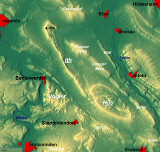
The Ith is a ridge in Germany's Central Uplands which is up to 439 m high. It lies about 40 km southwest of Hanover and, at 22 kilometres, is the longest line of crags in North Germany.

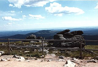
At 971 m above sea level (NN) the Wurmberg is the second highest mountain in the Harz and the highest in Lower Saxony (Germany).

The Dennert Fir Tree is a signboard that is used throughout the Harz mountains in Germany to provide information about mining and other points of interest in the area. The signboards mark locations, traces and monuments to mining, to the Upper Harz Water Regale, a medieval water management system, or even personalities in mining history in the Upper Harz mining area. They have since become used to document other notable sites within the Harz.

The Upper Harz is the northwestern and higher part of the Harz mountain range in Germany. The exact boundaries of this geographical region may be defined differently depending on the context. In its traditional sense, the term Upper Harz covers the area of the seven historical mining towns (Bergstädte) - Clausthal, Zellerfeld, Andreasberg, Altenau, Lautenthal, Wildemann and Grund - in the present-day German federal state of Lower Saxony. Orographically, it comprises the Harz catchment areas of the Söse, Innerste and Grane, Oker and Abzucht mountain streams, all part of the larger Weser watershed.
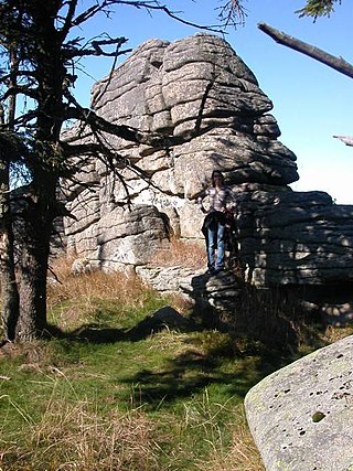
The Hirschhorn Rocks are a natural monument in the Harz National Park in central Germany.

Regenstein Castle is a ruined castle that lies three kilometres north of Blankenburg in the German state of Saxony-Anhalt. It is a popular tourist destination where, each year, a knight's tournament and a garrison festival are held.

Harz granite is found in the Harz Mountains of central Germany. It may be divided into five types, all of which were widely used as natural stone: Knaupsholz granite, Birkenkopf granite, Wurmberg granite, Königskopf granite and Ilsestein granite. The first three granites were widely used in North Germany, Belgium and the Netherlands and, later, also in East Germany. Knaupsholz granite was "for a long time one of the most important types of cut stone in the former GDR".

The Königstein is a 189 m high hill in the northern Harz Foreland in the German state of Saxony-Anhalt. It is also known as the Kamelfelsen due to its unusually shaped sandstone rock formation.
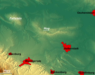
The Großer Fallstein is a wooded hill region in the German state of Saxony-Anhalt. It lies in the district of Harz on the territory of the town of Osterwieck, north of the Harz Mountains. Its highest point has an elevation of 288 metres above sea level (NN).

Old Falkenstein Castle in the Harz Mountains of Germany is the castle site or burgstall of a high medieval hill castle. It lies on the territory of Falkenstein/Harz in the state of Saxony-Anhalt in the district of Harz. It was built in the 11th century A.D. and destroyed in 1115.


