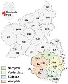
The Palatinate, or the Rhenish Palatinate (Rheinpfalz), is a historical region of Germany. The Palatinate occupies most of the southern quarter of the German federal state of Rhineland-Palatinate (Rheinland-Pfalz), covering an area of 2,105 square miles (5,450 km2) with about 1.4 million inhabitants. Its residents are known as Palatines (Pfälzer).
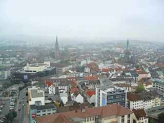
Kaiserslautern is a town in southwest Germany, located in the state of Rhineland-Palatinate at the edge of the Palatinate Forest. The historic centre dates to the 9th century. It is 459 kilometres from Paris, 117 km from Frankfurt am Main, 666 kilometers from Berlin, and 159 km from Luxembourg.

Mont-Tonnerre was a department of the First French Republic and later the First French Empire in present-day Germany. It was named after the highest point in the Palatinate, the Donnersberg. It was the southernmost of four departments formed in 1797 when the west bank of the Rhine was annexed by France. Prior to the French occupation, its territory was divided between the Archbishopric of Mainz, the Bishopric of Speyer, the Bishopric of Worms, Nassau-Weilburg, Hesse-Darmstadt, the Electorate of the Palatinate and the imperial cities of Worms and Speyer. Its territory is now part of the German states of Rhineland-Palatinate and Saarland. Its capital was Mainz.

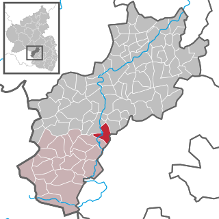
Pirmasens is an independent town in Rhineland-Palatinate, Germany, near the border with France. It was famous for the manufacture of shoes. The surrounding rural district was called Landkreis Pirmasens from 1818 until 1997, when it was renamed to Südwestpfalz.

Rockenhausen is a town in the Donnersbergkreis, in Rhineland-Palatinate, Germany. It is situated on the river Alsenz, approx. 30 km (19 mi) north of Kaiserslautern.

Obermoschel is a town and municipality in the district Donnersbergkreis, Rhineland-Palatinate, Germany. With around 1,000 residents, it is the smallest town in the Palatinate (Pfalz). It is part of the Verbandsgemeinde Nordpfälzer Land, which has its seat of administration in community of Rockenhausen and an administrative office in Alsenz. According to regional planning, Obermoschel is designated as lower-order center (Grundzentrum).
Sembach is a municipality in the district of Kaiserslautern in the state of Rhineland-Palatinate, Germany. It forms part of the Verbandsgemeinde of Enkenbach-Alsenborn. The town is nestled in the Palatinate Forest Nature Park between Kaiserslautern and Donnersbergkreis. Sembach was first mentioned in the 13th century, in a document about a donation to the monastery of Enkenbach.

Gundersweiler is a village and a municipality in the Verbandsgemeinde Nordpfälzer Land and the Donnersbergkreis district, in Rhineland-Palatinate, Germany. It is located in the valley of Moschelbach in the North Palatine Uplands, southwest of Donnersberg and between Kaiserslautern and Bad Kreuznach.

Schopp is a municipality in the district of Kaiserslautern, in Rhineland-Palatinate, western Germany. Schopp station lies on the Biebermühl Railway.

Föckelberg is an Ortsgemeinde – a municipality belonging to a Verbandsgemeinde, a kind of collective municipality – in the Kusel district in Rhineland-Palatinate, Germany. It belongs to the Verbandsgemeinde of Kusel-Altenglan, whose seat is in Kusel.
Matzenbach is an Ortsgemeinde – a municipality belonging to a Verbandsgemeinde, a kind of collective municipality – in the Kusel district in Rhineland-Palatinate, Germany. It belongs to the Verbandsgemeinde of Oberes Glantal.

Merzalben is a municipality in Südwestpfalz district, in Rhineland-Palatinate, western Germany, deriving its name from the Merzalbe, also known as the Merzalb, that flows through the village. Along with 5 other Ortsgemeinden Merzalben belongs to the Verbandsgemeinde Rodalben in Südwestpfalz, wherein it is the largest in terms of physical area, but the smallest in terms of population. The municipality contains several distinct natural and cultural landmarks, with the earliest known records dating back to 1237. It was also considered a state-approved tourist resort before the title was dropped in Rhineland Palatinate in 2016 and all communities awarded the designation were barred from its use in 2020.
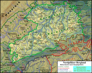
The North Palatine Uplands, sometimes shortened to Palatine Uplands, is a low mountain range and landscape unit in the German state of Rhineland-Palatinate and belongs mainly to the Palatinate region. It is part of the Saar-Nahe Uplands.
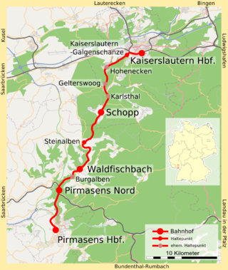
The Biebermühl Railway —sometimes called the Moosalbbahn —is a 35.9 km long railway line from Kaiserslautern to Pirmasens in the German state of Rhineland-Palatinate, which was built between 1875 and 1913. The first section between Biebermühle and Pirmasens connected the city of Pirmasens to the railway network, which could only be achieved via a branch line due to the topography. In 1905, another branch was opened from Biebermühl to Waldfischbach, which was extended in 1913 to Kaiserslautern. It was subsequently used by long-distance services, which operated until 1990. Since then, it has been used only by local services. It is the only one of all the Palatine railway lines that were completed in the 20th century that have never been threatened with closure.
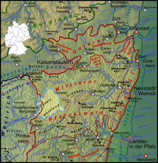
Holzland is the name of a region in the western part of the Palatine Forest in the German state of Rhineland-Palatinate
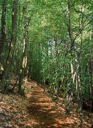
Walking routes in the Palatine Forest fall into two categories. The first are longer walking routes, most of which are maintained by the Palatine Forest Club, or PWV, and which are linked to the national and international network of long distance paths. The second category are those local circular walks and themed walking routes, some of which are of wider regional importance, and which are maintained by municipal authorities. The Palatine Forest, as part of the Palatine Forest-North Vosges Biosphere Reserve, is an important conservation area. As a result, the Palatine Forest, the bunter sandstone landscape of the Palatine Forest Nature Park, the castles in the Dahner Felsenland and the cross-border paths into Alsace and the Vosges make the region particularly popular with ramblers and walkers.
The West Palatinate Way was a marked footpath that crossed the West Palatinate region in Germany, but is no longer maintained. The concept for this route emerged in 1980 from its sponsor the Association for the Promotion of Tourism in the West Palatinate and was a cooperative venture between the counties in the West Palatinate, the Palatine Forest Club and local pubs and restaurants. In 2006 and 2007, overnight bookings fell and, since 2009, the sponsors have no longer taken bookings and maintenance of the footpath and its waymarks has only been carried out in places by the Palatinate Club. The disbandment of the tourist association has also been discussed.

The Palatine Ways of St. James are those sections of the Way of St. James in the Palatinate region of Germany and part of the historic pilgrimage route to the northwest Spanish town of Santiago de Compostela. It was there that, according to Christian tradition, the Apostle Saint James the Greater was buried.

The Sickingen Heights form a landscape in the western part of the German state of Rhineland-Palatinate. The region was named after the family of imperial knight, Franz von Sickingen (1481–1523), because most of the area belonged to the territory of the House of Sickingen in the Middle Ages.

Pirmasens is an electoral constituency represented in the Bundestag. It elects one member via first-past-the-post voting. Under the current constituency numbering system, it is designated as constituency 209. It is located in southern Rhineland-Palatinate, comprising the cities of Pirmasens and Zweibrücken, the Südwestpfalz district, and the southwestern part of the Landkreis Kaiserslautern district.