Related Research Articles
The Cree are a North American Indigenous people. They live primarily in Canada, where they form one of that country's largest First Nations.

James Bay is a large body of water located on the southern end of Hudson Bay in Canada. Both bodies of water extend from the Arctic Ocean, of which James Bay is the southernmost part. It borders the Canadian provinces of Quebec and Ontario. Islands within the bay, the largest of which is Akimiski Island, are part of Nunavut.
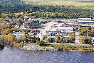
Moosonee is a town in northern Ontario, Canada, on the Moose River approximately 19 km (12 mi) south of James Bay. It is considered to be "the Gateway to the Arctic" and has Ontario's only saltwater port. Nearby on Moose Factory Island is the community of Moose Factory to which it is connected by water taxi in the summer and ice road in the winter.

Waskaganish is a Cree community of over 2,200 people at the mouth of the Rupert River on the south-east shore of James Bay in Northern Quebec, Canada. Waskaganish is part of the territory referred to as "Eeyou Istchee" encompassing the traditional territories of Cree people in the James Bay regions of what is now Northern Quebec and Ontario.
Moose Factory is a community in the Cochrane District, Ontario, Canada. It is located on Moose Factory Island, near the mouth of the Moose River, which is at the southern end of James Bay. It was the first English-speaking settlement in lands now making up Ontario and the second Hudson's Bay Company post to be set up in North America after Fort Rupert. On the mainland, across the Moose River, is the nearby community of Moosonee, which is accessible by water taxi in the summer, ice road in the winter, and chartered helicopter in the off-season.
King's Highway 69, commonly referred to as Highway 69, is a provincially maintained north–south highway in the central portion of the Canadian province of Ontario. In conjunction with Highway 400, it links Toronto with the city of Greater Sudbury at Highway 17, via Parry Sound. It is part of the Trans-Canada Highway and the National Highway System. From its southern terminus of Highway 559 at Carling, Highway 69 begins as Highway 400 narrows from a four-laned freeway to a two lane highway. It travels northerly for approximately 68 kilometres (42 mi) to south of the French River before widening back to a divided four lane freeway for approximately 64 kilometres (40 mi) into Sudbury. The final 6 kilometres (3.7 mi) of the route, connecting to Highway 17, is a five lane arterial road that will be converted to freeway as the final phase of the four-laning.

Fort Albany First Nation is a Cree First Nation reserve in Cochrane District in Northeastern Ontario, Canada. Situated on the southern shore of the Albany River, Fort Albany First Nation is accessible only by air, water, or by winter road.
Neskantaga First Nation is a remote Oji-Cree First Nation band government in the northern reaches of the Canadian province of Ontario, situated along the shore of Attawapiskat Lake in the District of Kenora.

The Attawapiskat First Nation is an isolated First Nation located in Kenora District in northern Ontario, Canada, at the mouth of the Attawapiskat River on James Bay. The traditional territory of the Attawapiskat First Nation extends beyond their reserve up the coast to Hudson Bay and hundreds of kilometres inland along river tributaries. The community is connected to other towns along the shore of James Bay by the seasonal ice road/winter road constructed each December, linking it to the towns of Kashechewan First Nation, Fort Albany, and Moosonee Attawapiskat, Fort Albany, and Kashechewan operate and manage the James Bay Winter Road through the jointly owned Kimesskanemenow Corporation, named after the Cree word for "our road" -kimesskanemenow. Attawapiskat is the most remote northerly link on the 310 km (190 mi) road to Moosonee. They control the reserves at Attawapiskat 91 and Attawapiskat 91A.
The Kashechewan First Nation is a Cree First Nation band government located near James Bay in Northern Ontario, Canada. The community is located on the northern shore of the Albany River. Kashechewan First Nation is one of two communities that were established from Old Fort Albany in the 1950s. The other community is Fort Albany First Nation, which is now located on the southern bank of the Albany River. The community is connected to other towns along the shore of James Bay by the seasonal ice road/winter road, linking it to the towns of Attawapiskat, Fort Albany, and Moosonee.

Alberta Provincial Highway No. 58, commonly referred to as Highway 58, is an east–west highway in northwest Alberta, Canada. It starts west of the Rainbow Lake Airport and passes through the towns of Rainbow Lake and High Level before it ends at the Wood Buffalo National Park boundary west of Garden River.
The Swampy Cree people, also known by their autonyms Néhinaw, Maskiki Wi Iniwak, Mushkekowuk,Maškékowak or Maskekon or by exonyms including West Main Cree,Lowland Cree, and Homeguard Cree, are a division of the Cree Nation occupying lands located in northern Manitoba, along the Saskatchewan River in northeastern Saskatchewan, along the shores of Hudson Bay and adjoining interior lands south and west as well as territories along the shores of Hudson and James Bay in Ontario. They are geographically and to some extant culturally split into two main groupings, and therefore speak two dialects of the Swampy Cree language, which is a "n-dialect":

The Hudson Bay Lowlands is a vast wetland located between the Canadian Shield and southern shores of Hudson Bay and James Bay. Most of the area lies within the province of Ontario, with smaller portions reaching into Manitoba and Quebec. Many wide and slow-moving rivers flow through this area toward the saltwater of Hudson Bay: these include the Churchill, Nelson and Hayes in Manitoba, Severn, Fawn, Winisk, Asheweig, Ekwan, Attawapiskat, and Albany in Ontario, and the Harricana, Rupert and Eastmain in Quebec. This is the largest wetland in Canada, and one of the largest in the world. The region can be subdivided into three bands running roughly northwest to southeast: the Coastal Hudson Bay Lowland, Hudson Bay Lowland, and James Bay Lowland.
Constance Lake First Nation is an Oji-Cree First Nations band government located on the shores of Constance Lake near Hearst, Cochrane District in northeastern Ontario, Canada. It is directly north of the community of Calstock along a continuation of Ontario Highway 663. Constance Lake First Nation is home to close to 1605 members of Cree and Ojibway ancestry with approximately 820 living on reserve. It may also be known as "Home of Sonny Sutherland". The reserves, Constance Lake 92 and English River 66, total 7,686 acres (3,110 ha) in size.
Mushkegowuk Council, or officially as the Mushkegowuk Tribal Council, is a non-profit regional chiefs' council representing Cree First Nations in northern Ontario, Canada. The council, located in Moose Factory, Ontario provides advisory services and program delivery to its eight member nations.
The Victor Mine was the first Canadian diamond mine located in Ontario, and De Beers' second diamond mine in Canada. It is located in the Northern Ontario Ring of Fire, in the James Bay Lowlands 90 kilometres (56 mi) west of Attawapiskat in the remote northern part of the province. In June 2005, the Attawapiskat First Nation voted in favour (85.5%) of ratifying the Impact Benefit Agreement (IBA). Construction of the mine began in February 2006 which created 3200 positions; mining and operations will create around 400 permanent positions. The Victor Mine is an open-pit mine, with a processing plant, workshops, and an airstrip located on site. By 2013–2014 royalties collected from De Beers Victor Mine amounted to $226. At that time De Beers was continuing to pay off its "$1 billion investment to build the mine and from now until it closes, the company expects to pay tens of millions of dollars in royalties." The mine completed mining and processing in 2019 and has moved to a shut-down phase including demolition of infrastructure and rehabilitation of the site.

The Moose Cree First Nation is a Cree First Nation band government in northern Ontario, Canada. Their traditional territory is on the west side of James Bay. The nation has two reserves: Factory Island 1 ; and Moose Factory 68, a tract of land about 15 km upstream on the Moose River covering 168.82 square kilometres (65.18 sq mi).
This is a list of elections in Canada scheduled to be held in 2018. Included are municipal, provincial and federal elections, by-elections on any level, referendums and party leadership races at any level. In bold are provincewide or federal elections and party leadership races.
Weeneebayko Area Health Authority (WAHA) is a health-care network operating hospitals and supporting federal nursing stations in remote communities along the James Bay and Hudson Bay coasts in Northern Ontario, Canada.
Midnight Shine is a Canadian roots-rock band from Northern Ontario and Manitoba, consisting of lead vocalist/guitarist Adrian Sutherland, bassist/vocalist Stan Louttit, guitarist/vocalist Zach Tomatuk and drummer Charnelle Menow. They have released three studio albums and three music videos and have been actively touring across Canada since 2016.
References
- ↑ "Archived copy" (PDF). Archived from the original (PDF) on 2017-10-19. Retrieved 2017-10-19.
{{cite web}}: CS1 maint: archived copy as title (link) - ↑ "Winter Road South - Moose Cree First Nation". www.moosecree.com. Retrieved 27 December 2018.
- ↑ "Since ice roads won't stay frozen, we need to get serious about building permanent roads in the far north". TVO. 24 January 2017. Retrieved 27 December 2018.
- ↑ "The Wetum Road: How much is connecting James Bay to the provincial highway worth?". TVO. 5 April 2016. Retrieved 27 December 2018.