Whairepo Lagoon

Last updated

Whairepo Lagoon, from the City-to-Sea bridge, circled by Frank Kitts Park, The Boatshed, Museum of New Zealand Te Papa Tongarewa, and the New Zealand Exchange before the construction of Te Raukura. Wellington lagoon.png
Whairepo Lagoon, from the City-to-Sea bridge, circled by Frank Kitts Park, The Boatshed, Museum of New Zealand Te Papa Tongarewa, and the New Zealand Exchange before the construction of Te Raukura.

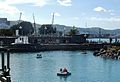
Whairepo Lagoon is an open public area at the centre of Wellington, New Zealand. It is a small man-made lagoon filled with sea water and connected to Wellington Harbour through a narrow channel. A split-level footbridge over the mouth of the lagoon was designed by Eastbridge. [1] The lagoon is surrounded by The Boat Shed, City-to-Sea bridge, and the Wellington Rowing, Star Boating Club, and Te Raukura buildings. Tanya Ashken's Albatross fountain sits on the north side of the lagoon between it and Frank Kitts Park.

Contents

On 17 December 2015 the lagoon was officially named Whairepo Lagoon, as it previously had no official name. The lagoon was previously referred to as Frank Kitts Lagoon, Frank Kitts Park Lagoon or simply The Lagoon. 'Whairepo' is the Maori name for the Eagle ray which can sometimes be seen in the lagoon. [2]

Related Research Articles

<span class="mw-page-title-main">Porirua</span> City in the North Island of New Zealand

Porirua, a city in the Wellington Region of the North Island of New Zealand, is one of the four cities that constitute the Wellington metropolitan area. The name 'Porirua' is a corruption of 'Pari-rua', meaning "the tide sweeping up both reaches". It almost completely surrounds Porirua Harbour at the southern end of the Kāpiti Coast. As of June 2022, Porirua had a population of 60,200.

<span class="mw-page-title-main">Hutt Valley</span> Valley in Greater Wellington, New Zealand

The Hutt Valley is the large area of fairly flat land in the Hutt River valley in the Wellington region of New Zealand. Like the river that flows through it, it takes its name from Sir William Hutt, a director of the New Zealand Company in early colonial New Zealand.

<span class="mw-page-title-main">Hutt River (New Zealand)</span> River in New Zealand

The Hutt River flows through the southern North Island of New Zealand. It flows south-west from the southern Tararua Range for 56 kilometres (35 mi), forming a number of fertile floodplains, including Kaitoke, central Upper Hutt and Lower Hutt.

<span class="mw-page-title-main">Whanganui</span> City in Manawatū-Whanganui, New Zealand

Whanganui, also spelled Wanganui, is a city in the Manawatū-Whanganui region of New Zealand. The city is located on the west coast of the North Island at the mouth of the Whanganui River, New Zealand's longest navigable waterway. Whanganui is the 19th most-populous urban area in New Zealand and the second-most-populous in Manawatū-Whanganui, with a population of 42,600 as of June 2022.

<span class="mw-page-title-main">Paremata</span> Suburb of Porirua

Paremata is a suburb of Porirua, on the Tasman Sea coast to the north of Wellington, New Zealand.

<span class="mw-page-title-main">Frank Kitts</span> New Zealand politician

Sir Francis Joseph Kitts was a New Zealand politician. Originally from the South Island, he served in the military and later was a civil servant before entering politics with the Labour Party. He was the Member of Parliament for Wellington Central between 1954 and 1960. He was also the longest-serving Mayor of Wellington, holding the post from 1956 to 1974. He was also a member at various times of several other local bodies and was still an elected official at his death.

<span class="mw-page-title-main">Oriental Bay</span> Suburb of Wellington City, New Zealand

Oriental Bay is a bay and suburb of Wellington, the capital city of New Zealand. Noted for being both a popular beach and a luxurious centre of affluence in the city, it is located close to the Central Business District on Wellington Harbour.

<span class="mw-page-title-main">Te Ngākau Civic Square</span> Public square in Wellington

Te Ngākau Civic Square is a public square in central Wellington, New Zealand, between the Wellington central business district to the north and the Te Aro entertainment district to the south.

<span class="mw-page-title-main">Wellington 500</span> Former motor racing event held in New Zealand

The Wellington 500 was a 500 km (310 mi) street race for touring cars which took place at Wellington City in Wellington, New Zealand in the 1980s and 1990s. The 1987 event was a round of the 1987 World Touring Car Championship.

<span class="mw-page-title-main">Courtenay Place, Wellington</span>

Courtenay Place is the main street of the Courtenay Quarter in the Wellington inner-city district of Te Aro.

<span class="mw-page-title-main">Te Whaea</span> New Zealand National Dance and Drama Centre, in Wellington

Te Whaea in Newtown, Wellington, New Zealand, is the New Zealand National Dance and Drama Centre, the home to the New Zealand School of Dance and Toi Whakaari: New Zealand Drama School.

<span class="mw-page-title-main">Te Raekaihau Point</span>

Te Raekaihau Point is a rugged coastal landform in Wellington, New Zealand, adjacent to Princess Bay, between Houghton Bay to the west and Lyall Bay to the east on the south coast. One meaning of the name is "the headland that eats the wind". Te Raekaihau Point proceeds from the Southern Headlands Reserve and remains an undeveloped interface with the Cook Strait.

The Terrace Tunnel takes the Wellington Urban Motorway (SH1) under The Terrace in central Wellington, New Zealand. Opened in 1978, it is 460 metres in length.

<span class="mw-page-title-main">Kaiwharawhara</span> Suburb in Wellington, New Zealand

Kaiwharawhara is an urban seaside suburb of Wellington in New Zealand's North Island. It is located north of the centre of the city on the western shore of Wellington Harbour, where the Kaiwharawhara Stream reaches the sea from its headwaters in Karori. It is a largely commercial and industrial area and thus has little residential population. A recent housing development up the hillside towards Te Kainga has increased the resident population.

<span class="mw-page-title-main">Frank Kitts Park</span>

Frank Kitts Park is a public park situated between Jervois Quay and the Lambton Harbour waterfront in Wellington, New Zealand. It is named after Sir Frank Kitts, New Zealand politician and mayor of Wellington.

<span class="mw-page-title-main">City to Sea Bridge</span> Bridge in Wellington City, New Zealand

The City to Sea Bridge is a pedestrian bridge and public artwork located in Wellington City, New Zealand. Opened on 31 October 1993, the wedge-shaped bridge crosses arterial road Jervois Quay, connecting the public spaces of Civic Square to the Wellington waterfront precinct at Whairepo Lagoon. Around the square are the Michael Fowler Centre, Wellington Town Hall, Wellington City Art Gallery and Wellington Central Library.

<span class="mw-page-title-main">Te Hopua a Rangi</span> Volcano in Auckland, New Zealand

Te Hopua a Rangi, also known as Gloucester Park is one of the volcanoes in the Auckland volcanic field in Auckland, New Zealand, and is located in Onehunga. Its 300 m wide, sediment-filled explosion (maar) crater was used as a boat harbour in early European times and known first as Onehunga Basin then as Geddes Basin. It was reclaimed in the 1930s and named Gloucester Park in 1935 after the visit to New Zealand by the Duke of Gloucester in that year. From 1975 into the early 80's the South-western motorway was built right through the middle of the park and crater. The southern side was turned into a sports ground, and the western side as a wetland with activity space for Aotea Sea Scouts who took ownership of the Manukau Yacht and Motor Boat Club (MYMBC) club house, in 1977.

<span class="mw-page-title-main">Robertson Hill</span>

Robertson Hill is one of the volcanoes in the Auckland volcanic field in New Zealand. It erupted approximately 24,300 years ago. The hill, alongside Māngere Lagoon, Waitomokia, Crater Hill, Kohuora and Pukaki Lagoon, is one of the volcanic features collectively referred to as Nga Tapuwae a Mataoho, referring to the deity in Tāmaki Māori myths who was involved in their creation.

<span class="mw-page-title-main">Te Raukura</span>

Te Raukura, otherwise known as Te Wharewaka o Poneke is a building located on Taranaki Street Wharf, Wellington waterfront, New Zealand. It houses a conference venue, Karaka Cafe, and waka house.

<span class="mw-page-title-main">Wellington Town Belt</span>

Wellington town belt and Outer green belt is a pair of strips of tree-filled wilderness spaces near and around central Wellington, New Zealand's capital city. The inner strip, the town belt, is an elongated U-shape. It was set aside by the city's founders in 1840. It is now about two-thirds of its original area. Portions have been repurposed for various mostly-public purposes, including Wellington Hospital, Victoria University of Wellington, Government House, Wellington Zoo, Wellington College, the Wellington Botanic Garden, and a range of other parks and recreational areas.

References

  1. "Hawke's Bay Base of Kiwi Bridge-builder For Sale". New Zealand Herald. 3 October 2020. p. D2 via Proquest Australia & New Zealand Newsstream.
  2. "Wellington Lagoon Gets a New Name". 17 December 2015.

41°17′19″S174°46′45″E / 41.288652°S 174.779037°E / -41.288652; 174.779037