Tapawera is a hamlet in New Zealand's South Island. It is located 30 kilometres southwest of Nelson by the banks of the Motueka River. The population including the surrounding area was 405 in the 2006 Census, an increase of 21 from 2001. The town is a gateway to the Kahurangi National Park.

Renwick is a small town in Marlborough, New Zealand, close to the south bank of the Wairau River. It is located on State Highway 6, 12 kilometres (7 mi) west of Blenheim. Havelock is 31 km (19 mi) north. State Highway 63 runs southwest from Renwick through the Wairau River valley.
The Mangahao River is located in the North Island of New Zealand. The headwaters are in the Tararua Ranges. The river flows northeast feeds into the Manawatu River south of Woodville.
The Ohura River is a river of the western North Island of New Zealand. It flows southward from its source close to the town of Ohura, and flows into the Whanganui River.
The Little Akatarawa River is a river of the Wellington Region of New Zealand's North Island. It is a tributary of the Akatarawa River, which it meets 5 kilometres (3 mi) northwest of Te Marua.
The Manganui o te Ao River is a river of the centre of New Zealand's North Island. It has its source in numerous streams and small rivers which flow west from the slopes of Mount Ruapehu, though the main course of the river flows predominantly southwest through rugged hill country to meet with the Whanganui River 10 kilometres (6 mi) north of Pipiriki, at the edge of the Whanganui National Park.
The Mangatawhiri River is a river of the Auckland and Waikato Regions of New Zealand's North Island. It flows generally southwest from its sources in the Hunua Ranges southeast of Clevedon before flowing through a system of irrigation canals at the northern edge of the Waikato Plains close to the town of Pokeno. It reaches the Waikato River close to the township of Mercer.
The Mangawharariki River is a river of the Manawatu-Wanganui Region of New Zealand's North Island. It flows northwest from the Ruahine Range to meet the Rangitikei River at Mangaweka.
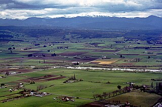
The Motupiko River is a river of the Tasman Region of New Zealand's South Island. A major tributary of the Motueka River, it flows north from its origins southeast of the Hope Saddle, meeting the Motueka at Kohatu Junction, 15 kilometres west of Wakefield. The Motupiko's tributaries include the Rainy River.
The Orikaka River is a river of the West Coast Region of New Zealand's South Island. It flows southwest from the southern end of the Matiri Range before turning south to flow into the Buller River five kilometres to the west of Inangahua.
The Penk River is a river of the Marlborough Region of New Zealand's South Island. It flows predominantly south from its origins on the slopes of Mount Horrible to reach the Awatere River 35 kilometres (22 mi) southwest of Seddon.
The Taumona River is a river of the Manawatu-Wanganui Region of New Zealand's North Island. It flows southwest from its origins 12 kilometres (7 mi) west of Taumarunui to reach the Ohura River.
The Waiotaka River is a river of the Waikato Region of New Zealand's North Island. It flows northwest from its origins in the Kaimanawa Range to reach the southern shore of Lake Taupo 5 kilometres (3 mi) northeast of Turangi.
The Wentworth River is a river of the Coromandel Peninsula, in the Waikato Region of New Zealand's North Island. It flows northeast from the Coromandel Range to reach the Bay of Plenty at Whangamata.
The Whakatikei River is a river of the Wellington Region of New Zealand's North Island. It flows generally southeast from its sources close to the west coast, 5 kilometres (3 mi) southeast of Paekakariki, and reaches the Hutt River at Upper Hutt.

Ball Glacier is a glacier 7 nautical miles (13 km) long with the head located between Mount Lister and Mount Hooker on the east side of the Royal Society Range. The glacier flows northeast between Craw Ridge and Tasman Ridge into Blue Glacier. It was named by the New Zealand Geographic Board after Gary Ball, a New Zealand mountaineer who climbed Mount Lister with an Italian field party, 1976–77, and camped on this glacier; he was field assistant with R.H. Findlay’s New Zealand Antarctic Research Program party to this area, 1980–81.
Mangatarere Stream is a small gravel-bed stream in central Wairarapa, New Zealand, that originates in the Tararua Ranges. It is located close to the township of Carterton and is the main tributary to the Waiohine River. The Waiohine flows into the Ruamahanga River, southeast of Greytown.

Pipiriki is a settlement in New Zealand, on the east bank of the Whanganui River, due west of the town of Raetihi and 79 kilometres (49 mi) upriver from Whanganui; it was originally on the opposite bank. It is the home of Ngāti Kura, a hapū of the Ngāti Ruanui iwi. It is also the location of the Paraweka Marae of the hapū Ngāti Kurawhatia of the iwi Te Āti Haunui-a-Pāpārangi.

Kaiwhaiki is a settlement 18 kilometres (11 mi) upriver from Whanganui, New Zealand.

The Cam River estuary is located in Somerset roughly halfway between the township of Wynyard and the city of Burnie on the North West Coast of Tasmania. The northern part of the Cam River forms part of the boundary between the City of Burnie and Waratah-Wynyard local government areas.


