See also
Coordinates: 35°43′30″S174°19′25″E / 35.72500°S 174.32361°E
| | This Northland Region-related geography article is a stub. You can help Wikipedia by expanding it. |
| Whangarei County | |
|---|---|
| County of New Zealand | |
| 1876–1989 | |
| Capital | Whangarei, New Zealand |
| History | |
| History | |
• Established | 1876 |
• Disestablished | 1989 |
| Today part of | Whangarei District |
Whangarei County was one of the counties of New Zealand in the North Island.
Coordinates: 35°43′30″S174°19′25″E / 35.72500°S 174.32361°E
| | This Northland Region-related geography article is a stub. You can help Wikipedia by expanding it. |

Moturoa / Rabbit Island is a small island that lies across the southernmost part of Tasman Bay / Te Tai-o-Aorere, on the northern coast of New Zealand's South Island. The long narrow island runs east–west for 8 kilometres (5 mi), and covers 15 km2 (5.8 sq mi).

The Scuppernong River is a blackwater river that flows through Tyrrell County and Washington County, North Carolina, into the Albemarle Sound. The river shares its name with the Scuppernong grapes native to the area.
Banana Island Provincial Park is a provincial park in British Columbia, Canada. It is a small 10.4 hectare island in the South Thompson River, located approximately 35 kilometres east of Kamloops. There are no camping or recreational facilities, as it is an environmentally sensitive area. The island was designated as a provincial park on 30 April 1996 following recommendations from the Kamloops Land and Resource Management Plan to protect spring salmon spawning grounds and nesting grounds for several varieties of birds. It is used for nesting by Canada geese, Osprey and bald eagles, and other waterfowl and raptors. It is also a winter habitat for Tundra and Trumpeter swans. The island is vegetated with ponderosa pine and grassy undercover, and was historically used by the Neskonlith First Nation in accessing river resources.
Aroha Island is a small island near Rangitane, which is about 12 km (7.5 mi) by road from Kerikeri in the Kerikeri Inlet, Bay of Islands, Northland, New Zealand. The island covers an area of 12 ha. It is owned and managed by the Queen Elizabeth II National Trust and is a major habitat for the North Island brown kiwi. It is linked to the mainland via a causeway.

Aorangaia Island is an island in the Northland Region of New Zealand, part of the Poor Knights Islands. It has a highest point of 102 metres (335 ft) and is 21 kilometres (13 mi) from the New Zealand mainland.

Colônia Leopoldina is a municipality located in the Brazilian state of Alagoas. Its population is 21,818 (2020) and its area is 287 km².
HMNZS Tui, formerly USNS Charles H. Davis (T-AGOR-5), was one of nine Conrad class oceanographic ships built for the United States Navy (USN), that later saw service in the Royal New Zealand Navy (RNZN). Serving with the USN from 1963 to 1970, these ships were designed to perform acoustic experiments on sound transmission underwater, and for gravity, magnetism and deep-ocean floor studies.

The Eagles Nest is a complex of five rental villas in the Bay of Islands of New Zealand, a few kilometres north of Russell. Located on a headland above the sea with good views of the bay, the secured compound is the most expensive rental accommodation of New Zealand, with a single night costing up to a five-figure sum in New Zealand $, depending which of the villas are chosen. Guests are also provided with amenities like personal chefs and Porsche cars.

HMNZS Puriri (T02) was a coastal cargo boat which was requisitioned by the Royal New Zealand Navy (RNZN) and converted into a minesweeper. She was sunk by a German mine 25 days after she was commissioned.

Whangarei District is a territorial authority district in the Northland Region of New Zealand that is governed by the Whangarei District Council. The district is made up in area largely by rural land, and includes a fifth of the Northland Region. It extends southwards to the southern end of Bream Bay, northwards to Whangaruru and almost to the Bay of Islands, and westwards up the Mangakahia River valley past Pakotai and almost to Waipoua Forest. It includes the Hen and Chicken Islands and the Poor Knights Islands.
Horahora is a suburb on the southwestern side of Whangārei, in Northland, New Zealand.

Nowe Młodochowo is a village in the administrative district of Gmina Raciąż, within Płońsk County, Masovian Voivodeship, in east-central Poland.
Sienno Górne is a village in the administrative district of Gmina Radowo Małe, within Łobez County, West Pomeranian Voivodeship, in north-western Poland. It lies approximately 9 kilometres (6 mi) west of Radowo Małe, 20 km (12 mi) west of Łobez, and 56 km (35 mi) north-east of the regional capital Szczecin.
Hóa Sơn is a commune (xã) and village in Minh Hóa District, Quảng Bình Province, in Vietnam.
Rodney County was one of the counties of New Zealand in the North Island, from 1876 until 1989. It came into existence in November 1876, when the provinces were abolished. In the 1989 local government reforms, it merged with Helensville Borough to create Rodney District.
Bay of Islands County was one of the counties of New Zealand in the North Island.
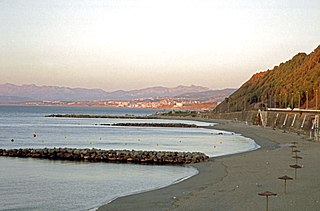
Playa del Chorrillo is a beach of Ceuta, a Spanish city bordering northern Morocco. Like the Playa de la Ribera, it lies to the south of the isthmus. It has a length of about 1200 metres and average width of 30 metres, with black sand.
The Emil or Emin, also spelled Emel, Imil, etc., is a river in China and Kazakhstan. It flows through Tacheng (Tarbagatay) Prefecture of China's Xinjiang Uighur Autonomous Region and the East Kazakhstan Province of Kazakhstan, and is one of the principal affluents of Lake Alakol.

The Counties Manukau District Health Board was a district health board which focused on providing healthcare to the Counties Manukau area in southern Auckland, New Zealand. As of 2016, it ws responsible for 534,750 residents; or 11% of New Zealand's population. In July 2022, CM Health was merged into the national health service Te Whatu Ora.
Clear Creek is a stream in Clay and Clinton counties of northwest Missouri. It is a tributary of the Fishing River.