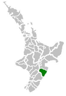
Hawke's Bay Region is a region of New Zealand on the east coast of the North Island. It is governed by Hawke's Bay Regional Council, which sits in the city of Napier. The region's name derives from Hawke Bay, which was named by Captain James Cook in honour of Admiral Edward Hawke.

Napier is a New Zealand city with a seaport, located in Hawke's Bay on the eastern coast of the North Island. The population of Napier is about 63,900 as of the June 2018. About 18 kilometres (11 mi) south of Napier is the inland city of Hastings. These two neighbouring cities are often called "The Bay Cities" or "The Twin Cities" of New Zealand. The total population of the Napier-Hastings Urban Area is 134,500 people, which makes it the sixth-largest urban area in New Zealand, closely followed by Dunedin (122,000), and trailing Tauranga (141,600).

Hastings is a New Zealand city and is one of the two major urban areas in Hawke's Bay, on the east coast of the North Island of New Zealand. The population of Hastings is 70,600, with 45,000 living in the contiguous city and Flaxmere, 13,950 in Havelock North, 2,210 in Clive, and the remainder in the peri-urban area around the city. Hastings is about 18 kilometres inland of the coastal city of Napier. These two neighbouring cities are often called "The Bay Cities" or "The Twin Cities". The combined population of the Napier-Hastings Urban Area is 134,500 people, which makes it the sixth-largest urban area in New Zealand, closely following Tauranga (141,600).

Hawke Bay is a large bay on the east coast of the North Island of New Zealand. It stretches from Mahia Peninsula in the northeast to Cape Kidnappers in the southwest, a distance of some 100 kilometres.
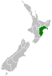
Central Hawke's Bay District is part of the Hawke's Bay Region in the North Island of New Zealand. It has an area of 3,327.92 square kilometres with a population of 14,150. It had a population of 12,717 people as of the 2013 census. This is a decrease of 237 people, or 1.8 percent, since the 2006 Census. It covers the area from Pukehou in the north to Takapau in the south, and from the western Ruahine Range to the Pacific coast in the east.
Clive is a small town, ten kilometres from the city centres of both Napier and Hastings in the Hawke's Bay region of New Zealand's North Island. It is close to the mouth of the Ngaruroro River.

Lake Tūtira is a body of water in north-eastern Hawke's Bay in New Zealand. Much of the area was surveyed by Herbert Guthrie-Smith, who farmed 60,000 acres (240 km²) surrounding the lake. Guthrie-Smith, a naturalist, published the popular Tutira: the story of a New Zealand sheep station in 1921. Today, a camp is run at the site of his homestead.

Whirinaki is a small settlement in the northern Hawke's Bay Region of New Zealand's eastern North Island. It lies close to the junction of State Highways 2 and 5, and is most notable as the location of Pan Pac Mill, one of Hawke's Bay's largest industrial plants.
Te Pohue is a small settlement in inland Hawke's Bay, in New Zealand's eastern North Island. It lies on State Highway 5, 31 kilometres inland from Whirinaki.
Ngāti Whare is a Māori iwi of New Zealand.
The Moerangi River or Moerangi Stream is found in New Zealand's Whirinaki Te Pua-a-Tāne Conservation Park. It is a fairly small river but is one of the main tributaries of the Waiau River, Hawke's Bay. The river is used by trampers (hikers), fisherman and hunters.
Waiapu was a New Zealand parliamentary electorate in the Gisborne – East Coast Region of New Zealand, from 1893 to 1908.
The Whirinaki Power Station is an open cycle gas turbine power station at Whirinaki, Hawke's Bay in New Zealand.
Whirinaki River is the name of two rivers in New Zealand's North Island:

The more northerly of the two rivers called Esk River in New Zealand lies in Hawke's Bay, in the eastern North Island. One of the region's major rivers, it flows south from the slopes of Mount Taraponui in the Maungaharuru Range before turning east to reach Hawke Bay 10 kilometres (6 mi) north of Napier. State Highway 5 follows the lower course of the river for several kilometres close to the settlement of Eskdale. The river is probably named after the Esk River in southern Scotland and north-west England.
Wairarapa and Hawke's Bay is a former parliamentary electorate in the Wellington region of New Zealand, from 1853 to 1859, when it was extended into previously unincorporated territories, split in two and replaced by County of Hawke with its southern portion being the newly created Wairarapa electorate. It is the first general electorate to have been abolished in New Zealand.

Minginui is a town in the Bay of Plenty Region in the North Island of New Zealand. The Whirinaki Te Pua-a-Tāne Conservation Park is in the vicinity of the town. The Statistics New Zealand 2006 census gives a population for the area of 1464, a reduction of 300 since 1996.
The Whirinaki River is a river of the Northland Region of New Zealand's North Island. It flows northwest from the Waima Forest to reach the Hokianga Harbour.


