Related Research Articles

Norman County is a county in the northwestern part of the U.S. state of Minnesota. As of the 2020 census, the population was 6,441. Its county seat is Ada. The county is in Minnesota's Red River Valley region.
Pipers Creek is a 1.4-mile (2.3 km) urban stream that is located in the Broadview and Blue Ridge neighborhoods of Seattle, Washington, in the United States.

Red Oak Creek or Bullock Creek is a 35 miles (56 km) stream and tributary of the Trinity River in North Texas.
Minnesota's 1st congressional district extends across southern Minnesota from the border with South Dakota to the border with Wisconsin. It is a primarily rural district built on a strong history of agriculture, though this is changing rapidly due to strong population growth in the Rochester combined statistical area. The district is also home to several of Minnesota's major mid-sized cities, including Rochester, Mankato, Winona, Austin, Owatonna, Albert Lea, Red Wing, New Ulm, Worthington, and Lake City. It is represented by Republican Brad Finstad.

The Sand Hill River is a 101-mile-long (163 km) tributary of the Red River of the North in northwestern Minnesota in the United States. Via the Red River, Lake Winnipeg, and the Nelson River, it is part of the watershed of Hudson Bay, and drains an area of 475 square miles (1,230 km2).
Abo is an unincorporated community in Torrance County, New Mexico, United States, located on U.S. Route 60. It is the nearest community to Abo, a pueblo and mission ruin of the same name that is a National Historic Landmark. A post office was operated here from 1910 to 1914.
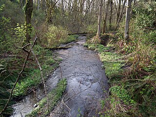
The Black River is a 33.7-mile-long (54.2 km) tributary of the Red Lake River of Minnesota in the United States. Via the Red Lake River, the Red River of the North, Lake Winnipeg, and the Nelson River, it is part of the Hudson Bay watershed.
The Hill River is a 60.8-mile-long (97.8 km) tributary of the Lost River of western Minnesota in the United States. Via the Lost River, the Clearwater River, the Red Lake River, the Red River of the North, Lake Winnipeg, and the Nelson River, it is part of the Hudson Bay watershed.
The Lost River is a 76.2-mile-long (122.6 km) tributary of the Clearwater River of northwestern Minnesota in the United States. Via the Clearwater River, the Red Lake River, the Red River of the North, Lake Winnipeg, and the Nelson River, it is part of the watershed of Hudson Bay.

The Pelican River is an 85.3-mile-long (137.3 km) tributary of the Otter Tail River of Minnesota in the United States.
The Rabbit River is a 31.5-mile-long (50.7 km) tributary of the Bois de Sioux River of Minnesota in the United States. Via the Bois de Sioux River, Red River of the North, Lake Winnipeg, and the Nelson River, it is part of the Hudson Bay watershed.
Twelvemile Creek is a 55.1-mile-long (88.7 km) tributary of the Mustinka River of Minnesota in the United States. It rises in Stevens County and flows northwest before joining the Mustinka in Traverse County. Via the Mustinka and Bois de Sioux rivers, the Red River of the North, Lake Winnipeg, and the Nelson River, it is part of the Hudson Bay watershed.
Ickesburg is a census-designated place in Saville Township, Perry County, Pennsylvania, United States at the junction of Routes 17 and 74. It is located on the Panther Creek, which flows into the Buffalo Creek, a tributary of the Juniata River. Its ZIP code is 17037 and it is served by area codes 717 and 223.
Gypsy is an unincorporated community in Creek County, in the U.S. state of Oklahoma. It is about twelve miles south-southwest of Bristow.
Ash Creek is a stream in Rock County, Minnesota, in the United States. It is a tributary of the Rock River.

Beaver Creek is a stream in Rock County, Minnesota and Minnehaha County, South Dakota. It is a tributary of Split Rock Creek.
Kanaranzi Creek is a stream in the U.S. states of Iowa and Minnesota.
Elk Creek is a stream in Nobles and Rock counties, in the U.S. state of Minnesota. It is a tributary of the Rock River.
Whisky Creek is a stream in the U.S. state of Washington. It is a tributary of the Touchet River.
French Mills is an unincorporated community in western Madison County, in the U.S. state of Missouri. The community is on [Little Rock Creek ], just north of that stream's confluence with the St. Francis River.
References
- ↑ U.S. Geological Survey Geographic Names Information System: Whisky Creek (Red River of the North)
- ↑ Upham, Warren (1920). Minnesota Geographic Names: Their Origin and Historic Significance. Minnesota Historical Society. p. 580.
46°27′21″N96°42′42″W / 46.45583°N 96.71167°W
| | This article related to a river or creek in Minnesota is a stub. You can help Wikipedia by expanding it. |