
The White Hart was the personal badge of Richard II, who probably derived it from the arms of his mother, Joan "The Fair Maid of Kent", heiress of Edmund of Woodstock. It may also have been a pun on his name, as in "Rich-hart". In the Wilton Diptych, which is the earliest authentic contemporary portrait of an English king, Richard II wears a gold and enamelled white hart jewel, and even the angels surrounding the Virgin Mary all wear white hart badges. In English Folklore, the white hart is associated with Herne the Hunter.
Suffolk Coastal was a local government district in Suffolk, England. Its council was based in Melton, having moved from neighbouring Woodbridge in 2017. Other towns include Felixstowe, Framlingham, Leiston, Aldeburgh, and Saxmundham.

The Blyth Navigation was a canal in Suffolk, England, running 7 miles (11 km) from Halesworth to the North Sea at Southwold. It opened in 1761, and was insolvent by 1884. Its demise was accelerated by an attempt to reclaim saltings at Blythburgh, which resulted in the estuary silting up. It was used sporadically until 1911, and was not formally abandoned until 1934.

The Fleece Inn is a public house in Bretforton, in the Vale of Evesham, Worcestershire, England: the half-timbered building, over six hundred years old, has been a pub since 1848, and is now owned by the National Trust. The inn was extensively damaged by fire on 27 February 2004, and after repairs and rebuilding were completed the Fleece officially reopened on 18 June 2005. The pub holds an annual asparagus festival and auction while there are three morris sides based at the pub: Pebworth, Belle d'Vain and Asum Gras. There is a regular folk night plus concerts and weddings in the medieval barn.

Nettlebed is a village and civil parish in the Chiltern Hills about 4 1⁄2 miles (7 km) northwest of Henley-on-Thames in Oxfordshire and 6 miles (10 km) southeast of Wallingford. The parish includes the hamlet of Crocker End, about 1⁄2 mile (800 m) east of the village. The 2011 Census recorded a parish population of 727.
The Old White Horse Inn in Bingley, West Yorkshire, England, is one of the oldest buildings still in use in the town. It was originally constructed as a coaching inn in the mid-seventeenth century, strategically positioned with Ireland Bridge on the one side and the Parish church on the other. The building is an English Grade II listed building and has a significant amount of coaching inn infrastructure surviving including a stable, barn and two coach entrances which are located around an inner courtyard. On each side of the gable are stone lanterns that denote the former owners Order of Knights of St John of Jerusalem. There is evidence that a hostelry has been on the site since 1379.
Hawkwell is the second largest village and civil parish in the district of Rochford in Essex, England, Rayleigh being the largest. The 2001 census gave a population for the parish of 111,231, increasing to 11,730 at the 2011 Census.

Blyford is a village and civil parish in the Waveney district of Suffolk, England, about 3 miles (5 km) east of Halesworth and separated from Wenhaston by the River Blyth, Suffolk to the south. It is in the civil parish of Sotherton.
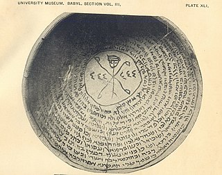
Jewish Babylonian Aramaic was the form of Middle Aramaic employed by writers in Lower Mesopotamia between the fourth and eleventh centuries. It is most commonly identified with the language of the Babylonian Talmud and of post-Talmudic (Geonic) literature, which are the most important cultural products of Babylonian Jews. The most important epigraphic sources for the dialect are the hundreds of inscriptions on incantation bowls.
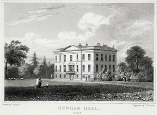
Henham Park is an historic 4,200 acre estate in the parish of Blythburgh, situated just north of the village of Blythburgh in the county of Suffolk, England, and at the intersection of the A12 and A145 main roads. It was historically the seat of the Earl of Stradbroke. In 1953 the 4th Earl demolished the Georgian manor house, known as Henham Hall.

The A145 is an A road in the English county of Suffolk. It runs from east of the town of Beccles, close to the border with Norfolk, to the village of Blythburgh where it joins the A12 road. It is around 11 miles (18 km) in length and single carriageway throughout.

The White Hart Inn, also known as the White Hart Hotel, is a coaching inn on the High Street in Crawley, a town and borough in West Sussex, England. Built in the late 18th century to replace an older inn also under the sign of the White Hart, it also served as Crawley's main post office for most of the 19th century, and still operates as a public house in the 21st century. Its partly timber-framed structure, which incorporates part of an early 17th-century building, is characteristic of the area. It is designated a Grade II Listed building.
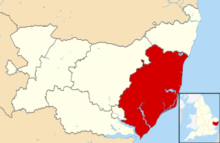
Blything was a hundred of eastern Suffolk, and with an area of 87,641 acres (354.67 km2) was the largest of Suffolk's 21 hundreds.
Blythburgh Priory was a medieval monastic house located in the Suffolk village of Blythburgh in England. It may be the site of the burials of Anglo-Saxon King Anna and his son Jurmin.

Jurmin also known as Hiurmine of Blythburgh, was an Anglo-Saxon prince who was the son and heir of Anna of East Anglia, a 7th-century king of East Anglia, a kingdom which today includes the English counties of Norfolk and Suffolk. Jurmin was venerated as a saint: his feast day is 24 February. His body was originally buried at Blythburgh Priory but later moved to Bury St Edmunds.

The A1095 road is an A road in the English county of Suffolk. It runs from Southwold on the North Sea coast to the A12 London to Lowestoft road at Henham between Blythburgh and Wangford. It is around 4 miles (6.4 km) in length and is single carriageway throughout. The entire length of the road lies within the Suffolk Coast and Heaths Area of Outstanding Natural Beauty.

Hen Reedbeds is a 55 hectare nature reserve near the North Sea coast of the English county of Suffolk. The reserve is located in the Blyth valley between Reydon and Blythburgh, approximately 2.5 miles (4.0 km) west of Southwold. The marshes make up part of the Suffolk Coast National Nature Reserve along with reserves at Walberswick and Dingle Marshes.
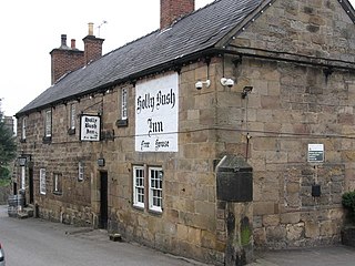
The Holly Bush Inn is a Grade II listed public house at 2 Holly Bush Lane, Makeney, Derbyshire, DE56 0RX. It is a family run pub.

The Boar's Head Inn was a tavern in Eastcheap in the City of London which is supposed to be the meeting place of Sir John Falstaff, Prince Hal and other characters in Shakespeare's Henry IV plays.


