Big Stone County is a county in the U.S. state of Minnesota. As of the 2010 United States Census, the population was 5,269. Its county seat is Ortonville.

Grant Valley Township is a township in Beltrami County, Minnesota, United States. The population was 2,029 at the 2010 census, up from 1,450 at the 2000 census. Grant Valley Township was named from its location in the valley of Grant Creek.

Almond Township is a township in Big Stone County, Minnesota, United States. The population was 190 as of the 2000 census. Almond Township was organized in 1880.

Graceville Township is a township in Big Stone County, Minnesota, United States. The population was 205 as of the 2000 census. Graceville Township took its name from the city of Graceville, which was named for Thomas Langdon Grace, second Roman Catholic Bishop of Saint Paul, Minnesota.

Odessa Township is a township in Big Stone County, Minnesota, United States. The population was 147 as of the 2000 census. Odessa Township was named after Odessa, Ukraine.

Ortonville Township is a township in Big Stone County, Minnesota, United States. The population was 2,011 as of the 2010 census.

Otrey Township is a township in Big Stone County, Minnesota, United States. The population was 104 as of the 2000 census.

Bassett Township is a township in Saint Louis County, Minnesota, United States. The township was named for William Bassett, a businessperson in the lumber industry. The population was 41 at the 2010 census.

White Township is an urban township in Saint Louis County, Minnesota, United States. The population was 3,229 at the 2010 census.

Big Stone Township is a township in Big Stone County, Minnesota, United States. The population was 253 at the 2000 census.

Shingobee Township is a township in Cass County, Minnesota, United States. The population was 1,745 as of the 2000 census. This township took its name from the Shingobee River.

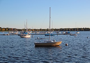
Bde Maka Ska is the largest lake in Minneapolis, Minnesota, United States, and part of the city's Chain of Lakes. Surrounded by city park land and circled by bike and walking trails, it is popular for many outdoor activities. The lake has an area of 401 acres (1.62 km2) and a maximum depth of 87 feet (27 m).

Big Stone Lake is a long, narrow freshwater lake and reservoir forming the border between western Minnesota and northeastern South Dakota in the United States.

Gooseberry Falls State Park is a state park of Minnesota, United States, on the North Shore of Lake Superior. The park is located in Silver Creek Township, about 13 miles (21 km) northeast of Two Harbors, Minnesota in Lake County on scenic Minnesota Highway 61. The park surrounds the mouth of the Gooseberry River and includes Upper, Middle and Lower Gooseberry Falls.

Big Stone Lake State Park is a state park of Minnesota, United States, on the shore of Big Stone Lake, the headwaters of the Minnesota River. It is home to wildlife including deer, raccoons, squirrels, meadowlarks, sedge wrens, pheasants, bobolinks, wild turkeys, thrashers, and mourning doves. The two sections of the park, the Bonanza Area in the north and the Meadowbrook Area in the south, are 12 miles (19 km) apart. South Dakota's Hartford Beach State Park is on the opposite shore of the lake. Big Stone Lake State Park is used for picnics, camping, hiking, and other outdoor recreation.

Lake Carlos State Park is a state park about 10 miles north of Alexandria, Minnesota, USA. The park was established in 1937 to provide a public recreational facility in one of Minnesota's summer resort centers, and attracts tourists from Minnesota and bordering states.

The Lake of the Woods State Forest is a state forest located south of Lake of the Woods in Beltrami, Koochiching, Lake of the Woods, and Roseau counties, Minnesota. The forest borders the Pine Island State Forest to the east and the Beltrami Island State Forest to the west.

The Northwest Angle State Forest is a state forest located in Lake of the Woods County, Minnesota. The name of the forest is derived from its location near the Northwest Angle, the northernmost point of the contiguous United States. The forest borders the Canadian provinces of Manitoba and Ontario, and the Red Lake Indian Reservation. The forest is managed by the Minnesota Department of Natural Resources.


