This article needs additional citations for verification .(January 2024) |

The Whitecars Coaches company ran daily coach services between Cairns and the Atherton Tableland, Australia until December 2007 when it ceased operation.
This article needs additional citations for verification .(January 2024) |
The Whitecars Coaches company ran daily coach services between Cairns and the Atherton Tableland, Australia until December 2007 when it ceased operation.
The inaugural trip of Cairns Tableland Motor Service Ltd was down the Gillies Highway on 10 June 1926, the day the Gillies Highway was officially opened, and the company was registered the day before – 9 June 1926. Whitecars became a hackneyed title for Cairns Tableland Motor Service Ltd as the first "buses" were Studebaker cars stretched to include an extra row of seats, and they were painted white for safety. The company was bought by other interests in 1947 and the founder purchased the company back in 1950 where it has remained in the family to this day, officially trading as Whitecar Coaches Pty Ltd.
These services are now operated by Trans North Bus & Coach [1]

Cairns is a city in Queensland, Australia, on the tropical north east coast of Far North Queensland. The population as of the 2021 census was 169,312, having grown on average 1.02% annually over the preceding five years. The city is the 5th-most-populous in Queensland, and 15th in Australia.

The Atherton Tableland is a fertile plateau, which is part of the Great Dividing Range in Queensland, Australia. It has very deep, rich basaltic soils and the main industry is agriculture. The principal river flowing across the plateau is the Barron River, which was dammed to form the irrigation reservoir named Lake Tinaroo. Unlike many other rural areas, the Tablelands is experiencing a significant growth in population.

Atherton is a rural town and locality in the Tablelands Region, Queensland, Australia. In the 2016 census, Atherton had a population of 7,331 people.

Kuranda is a rural town and locality on the Atherton Tableland in the Shire of Mareeba, Queensland, Australia. In the 2016 census, Kuranda had a population of 3,008 people. It is 25 kilometres (16 mi) from Cairns, via the Kuranda Range road. It is surrounded by tropical rainforest and adjacent to the Wet Tropics of Queensland World Heritage listed Barron Gorge National Park.
The Northern Division of the Queensland Rugby League is responsible for administering the game of rugby league in North Queensland, specifically in the area from Sarina in the south to Cape York and the Torres Strait Islands in the north and west to Mount Isa as well as into the Gulf Communities. There are over 8000 registered players across 36 senior clubs and 39 junior clubs in this division. The Northern Division is responsible for the historic Foley Shield competition that is held each year. Mid West and Mount Isa play in the Toyota Outback Carnival.

The Kennedy Highway is a highway in northern Queensland, Australia. It runs as National Route 1 for approximately 243 km from Smithfield, on the northern outskirts of Cairns, to the Gulf Developmental Road in the vicinity of Forty Mile Scrub and Undara Volcanic national parks. South of this junction, the road continues as the Kennedy Developmental Road to Boulia about 936 kilometres away, via Hughenden. West of the junction, National Route 1 continues as the Gulf Developmental Road to Normanton.

Curtain Fig Tree is a heritage-listed tree at Curtain Fig Tree Road, Yungaburra, Tablelands Region, Queensland, Australia. It is one of the largest trees in Tropical North Queensland, Australia, and one of the best known attractions on the Atherton Tableland. It was added to the Queensland Heritage Register on 3 December 2009.

Ravenshoe is a rural town and locality in the Tablelands Region, Queensland, Australia. In the 2021 census, the locality of Ravenshoe had a population of 1,332 people.

The Shire of Herberton was a local government area of Queensland. It was located on the Atherton Tableland, a plateau forming part of the Great Dividing Range west of the city of Cairns. The shire, administered from the town of Herberton, covered an area of 9,607.0 square kilometres (3,709.3 sq mi), and existed as a local government entity from 1895 until 2008, when it amalgamated with several other councils in the Tableland area to become the Tablelands Region.

The Roman Catholic Diocese of Cairns is a diocese of the Catholic Church located in the state of Queensland, Australia. It is a suffragan diocese of the Archdiocese of Brisbane. The diocese was erected as a vicariate apostolic in 1877 and was elevated to a diocese in 1941. Its territorial remit is Far North Queensland.

The Kuranda Range road is an informally named section of the Kennedy Highway in Queensland, Australia. The road traverses the Macalister Range near Cairns. The 11.5 kilometres (7.1 mi) section of road connects Smithfield, a suburb of Cairns in the Cairns Region with Kuranda, a town in the Shire of Mareeba on the Atherton Tableland, at an altitude of about 360 metres (1,180 ft). Traffic is primarily limited to one lane each way, with overtaking lanes at various points. The Kuranda Skyrail cableway crosses the road twice. Henry Ross Lookout is located near the road's highest point, at an altitude of 430 metres (1,410 ft), and is named after the foreman in charge of building the road to cross the range in 1939.

The Gillies Highway is a road that runs from Gordonvale in the Cairns Region through the Gillies Range to Atherton in the Tablelands Region, both in Queensland, Australia. Its official name is Gillies Range Road, and it was originally known as the Cairns Range Road.

The Tablelands Region is a local government area in Far North Queensland, Australia inland from the city of Cairns. Established in 2008, it was preceded by four previous local government areas which dated back more than a century. On 1 January 2014, one of those local government areas, the Shire of Mareeba, was re-established independent of the Tablelands Region.
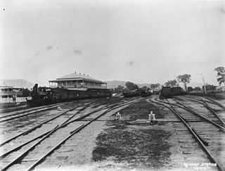
The Tablelands railway line is a railway line in North Queensland, Australia. It was opened in a series of sections between 1887 and 1916. It commences at Cairns and at its maximum extent, reached Ravenshoe at the southern end of the Atherton Tableland. The rail system served by this line was unusual for Queensland in that the majority of lines that connected to it were built by private companies and later purchased by the Queensland Government.

Innot Hot Springs is a rural town and locality in the Tablelands Region, Queensland, Australia. In the 2016 census, the locality of Innot Hot Springs had a population of 177 people.

Malanda Falls Swimming Pool is a heritage-listed swimming pool at Malanda Falls Park, Malanda, Tablelands Region, Queensland, Australia. It was built from 1906 onwards. It was added to the Queensland Heritage Register on 5 February 2010.

St Patrick's Church is a heritage-listed Roman Catholic church at 1 Penda Street, Yungaburra, Tablelands Region, Queensland, Australia. It was built from 1914 to 1930s. It is also known as Our Lady of Ransom. The church is part of the Roman Catholic Diocese of Cairns. It was added to the Queensland Heritage Register on 21 October 1992.

Middlebrook is a rural locality in the Tablelands Region, Queensland, Australia. In the 2021 census, Middlebrook had a population of 62 people.
Atherton–Herberton–Longlands Gap Road is a continuous 33.5-kilometre (20.8 mi) road route in the Tablelands local government area of Queensland, Australia. It has two official names, Atherton–Herberton Road and Longlands Gap–Herberton Road. The entire route is signed as part of State Route 52. Both parts are state-controlled district roads, numbered 663 and 665, and the entire road is rated as a local road of regional significance (LRRS).
Atherton–Malanda–Millaa Millaa Road is a continuous 39.0-kilometre (24.2 mi) road route in the Tablelands local government area of Queensland, Australia. It has two official names, Malanda–Atherton Road and Millaa Millaa–Malanda Road. The entire route is signed as part of State Route 25. Malanda–Atherton Road is a state-controlled district road, while Millaa Millaa–Malanda Road is part regional and part district.