
Charing Cross Road is a street in central London running immediately north of St Martin-in-the-Fields to St Giles Circus, which then merges into Tottenham Court Road. It leads from the north in the direction of Charing Cross at the south side of Trafalgar Square. It connects via St Martin's Place and the motorised east side of the square.

Tottenham Court Road is a major road in Central London, almost entirely within the London Borough of Camden.

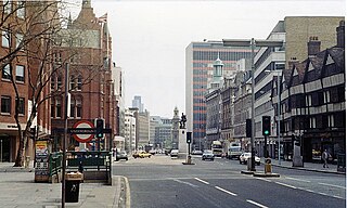
St Giles Circus is a road junction in the St Giles district of the West End of London at the eastern end of Oxford Street, where it connects with New Oxford Street, Charing Cross Road and Tottenham Court Road, which it is more often referred to owing to the location of Tottenham Court Road Underground station directly under the junction. It is near to Soho, Covent Garden, Bloomsbury and Fitzrovia.
High Holborn is a street in Holborn and Farringdon Without, Central London, which forms a part of the A40 route from London to Fishguard. It starts in the west at the eastern end of St Giles High Street and runs past the Kingsway and Southampton Row, becoming Holborn at its eastern junction with Gray's Inn Road. The western stretch, as far as Drury Lane, was formerly known as Broad Street. On High Holborn, traffic flows one-way westbound from its junction with Drake Street to its western end, and flows both ways for the remainder.
Malet Street is a street in Bloomsbury, in the London Borough of Camden, Central London, England. It runs between Torrington Place and the British Museum, parallel to Gower Street and Tottenham Court Road.

Tottenham High Road is the main thoroughfare through the district of Tottenham, in the London Borough of Haringey. It runs from Edmonton in the North to Stamford Hill in the South. South of Bruce Grove the road is part of the A10; to the north it is part of the A1010. Tottenham High Road passes through the London postcode areas of N17 and N15 and is 2.3 miles in length.

The New Road was a toll road built across fields around the northern boundaries of London, the first part of which opened in 1756. The route comprises the modern-day A501.

51.5976°N 0.0704°W

The Bedford Estate is an estate in central London owned by the Russell family, which holds the peerage title of Duke of Bedford. The estate was originally based in Covent Garden, then stretched to include Bloomsbury in 1669. The Covent Garden property was sold for £2 million in 1913 by Herbrand Russell, 11th Duke of Bedford, to the MP and land speculator Harry Mallaby-Deeley, who sold his option to the Beecham family for £250,000; the sale was finalised in 1918.

Rathbone Place is a street in central London that runs roughly north-west from Oxford Street to Percy Street. it is joined on its eastern side by Percy Mews, Gresse Street, and Evelyn Yard. The street is mainly occupied by retail and office premises.

Percy Street is a street in the London Borough of Camden that runs from Rathbone Street in the west to Tottenham Court Road in the east. At its western end it is joined by Rathbone Place and Charlotte Street. Nearby Percy Mews is off Rathbone Place. The street was built in the 1760s and is known for the number of artists that have lived there.
Rathbone Street is a street in London that runs between Charlotte Street in the north and the junction of Rathbone Place and Percy Street in the south. The street is partly in the London Borough of Camden and partly in the City of Westminster.

The Duke of York is a public house at 47 Rathbone Street, Fitzrovia, London, W1. It is located in the north of the street on the corner with Charlotte Place and bears the year 1791.

The American International Church, currently located at the Whitefield Memorial Church on Tottenham Court Road in London, was established to cater for American expatriates resident in London. Organised in the American denominational tradition, the church was originally named the American Church in London but changed its name in 2013 to reflect that it caters to approximately 30 different nationalities.

Torrington Place is a street in London that runs between Tottenham Court Road in the West and Byng Place in the East. It is crossed by Huntley Street and Gower Street. Chenies Mews joins it on the north side and is continued by Ridgmount Gardens on the south side.

Store Street is a street in Bloomsbury, London.

Warren Street is a street in the London Borough of Camden that runs from Cleveland Street in the west to Tottenham Court Road in the east. Warren Street tube station is located at the eastern end of the street.

Grafton Way is a street in the London Borough of Camden that runs from Gower Street in the east to Fitzroy Street in the west, crossing Tottenham Court Road half way along its length. Whitfield Street and Grafton Mews adjoin Grafton Way.

Chitty Street is a street in the London Borough of Camden that runs between Charlotte Street and Whitfield Street. Charlotte Mews adjoins Chitty Street on its south side.

Scala Street is a street in the London Borough of Camden that runs between Charlotte Street and Whitfield Street. It was formerly known as Pitt Street but was renamed after the Scala Theatre when this occupied most of its north side. The street's postcode is W1T 2HW.
