Related Research Articles
Balga is a suburb of Perth, the capital city of Western Australia, 13 kilometres (8 mi) north of Perth city's central business district (CBD). Its local government area is the City of Stirling. Mark Irwin is the current mayor.
Westville is an area in KwaZulu-Natal, South Africa, and is just west and 10 km inland from the Durban CBD. It was a formerly independent municipality however it became part of the eThekwini Metropolitan Municipality in 2002.

Sorrento is a northern coastal suburb of Perth, the capital city of Western Australia in the local government area of the City of Joondalup. At its northwestern corner is the Hillarys Boat Harbour, built in the late 1980s.
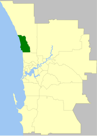
The Division of Moore is an Australian electoral division in the state of Western Australia.

Clarkson is an outer northern suburb of Perth, Western Australia, located 34 kilometres north of Perth's central business district in the City of Wanneroo.
Beldon is a small suburb of Perth, Western Australia, located within the City of Joondalup, to the north of Craigie.
Craigie is a northern suburb of Perth. Craigie was chosen as a suburb name in 1970 and honours an early councillor of the City of Wanneroo who did work in developing the City. Craigie is one of the four "Whitfords" suburbs that resulted from the State Government rezoning a large area of coastal land for development in 1969.
Heathridge is a suburb of Perth, Western Australia, located 33 kilometres (21 mi) south of Yanchep within the City of Joondalup.
Hillarys is a northern coastal suburb of Perth, the capital city of Western Australia, in the local government area of the City of Joondalup. It is part of the Whitfords precinct, and is located 21 km north-northwest of Perth's central business district via Mitchell Freeway and Hepburn Avenue.

Woodvale is a suburb of Perth, Western Australia, located within the City of Joondalup and the City of Wanneroo. At the 2016 census Woodvale had a population of 9,276.
Padbury is a suburb of Perth, Western Australia, located within the City of Joondalup. Its postcode is 6025. The suburb was named in 1971 after the notable Western Australian settler Walter Padbury. Several locations in the north section of Padbury bordering Whitfords Avenue take on the name Whitfords. The south east corner of the suburb also goes by the name of Hepburn Heights, and the most eastern part of Padbury is often called Pinnaroo Heights. Padburys population in 2021 was 8,626.

Wanneroo Road is a 44-kilometre (27 mi) arterial highway in the northern suburbs of Perth, Western Australia linking Joondanna and Yokine in the south with Wanneroo and Yanchep in the north. As part of State Route 60, it begins from Charles Street in the inner city and becomes Indian Ocean Drive up to Dongara.
The City of Joondalup is a local government area in Perth, Western Australia. Its central business district is located in the suburb Joondalup, and it includes the town centres of Hillarys and Warwick.

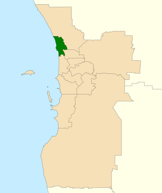
Hillarys is an electoral district of the Legislative Assembly in the Australian state of Western Australia.

Westfield Whitford City, formerly Whitford City Shopping Centre, is a major shopping centre located in Hillarys, east of St. Mark's Anglican Community School in Perth, Western Australia. Built in 1977 on the former Red Cattle Ridge site at Marmion Avenue approximately 18 kilometres north of the Perth central business district, the centre is owned by the Scentre Group.

Padbury Senior High School was a government, co-educational, secondary day school located in Padbury, a suburb north of Perth, Western Australia.

Hepburn Avenue is an arterial east-west road in the northern suburbs of Perth, Western Australia. The road links Sorrento in the west with Malaga and Whiteman in the east. It also connects the residential developments that span its length with several local facilities, as well as major road routes into central Perth.

Whitfords Avenue is an arterial east–west road located in the northern suburbs of Perth, Western Australia.
Ocean Reef Road is an arterial east-west road in Perth, Western Australia. It is located within the northern suburbs of Perth, from Ocean Reef in the west, to Landsdale in the east, with a portion travelling northwards along the coast to Iluka.
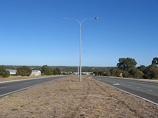
Hodges Drive is a main west–east road in Joondalup, north of Perth, Western Australia. It begins in the suburb of Ocean Reef at a T-junction with Ocean Reef Road and runs through the residential areas in Ocean Reef, Connolly and Heathridge, before terminating at Joondalup Drive. The road continues from there as Grand Boulevard. Hodges Drive is a four lane dual-carriageway for its entire length.
References
- ↑ "Hillarys Electorate Profile". Australian Broadcasting Corporation. Retrieved 19 August 2016.
Coordinates: 31°47′45″S115°45′14″E / 31.7957°S 115.754°E
| | This article about a location in Western Australia is a stub. You can help Wikipedia by expanding it. |