Whittle Hall

Last updated

Whittle Hall is housing estate within the parish of Great Sankey in the town of Warrington, in the Warrington district, in the ceremonial county of Cheshire, England. Its more exact location is in-between the old centre of Great Sankey, the new built Chapleford, and the Omega Development Site (formerly RAF Burtonwood). The area falls under the WA5 postal code. The estate consisted originally of Whittle Hall Farm and its surrounding fields, however as part of the Warrington new town development, the last 20 years have seen the fields turned into modern houses. The estate also contains Whittle Hall Community Centre and the original farm building which are now due to be demolished for a proposed redevelopment. As the estate is part of the new town development, the people who reside there are originally from all over the UK.

Contents

Shops

The estate itself contains no retail outlets. The area surrounding Sankey Station (10 minutes walk) hosts two pubs, two convenience stores, a hairdresser, a take away offering English, Chinese and pizzas, a computer shop and an independent sandwich shop. An Asda superstore is located 5 minutes drive or 45 minutes walk away at Westbrook. Gemini Retail Park (10 minutes drive) hosts a massive Marks & Spencer, the UK's first IKEA, and the closest McDonald's to the estate. High Street shopping is available in the town centre at the newly refurbished Golden Square Shopping Mall.

Governance

The area has three councillors in the Warrington Borough Council and five councillors representing the area on Great Sankey Parish Council. The area falls under the Warrington South constituency for which Andy Carter is the current Member of Parliament (Conservative Party)

Transport

Bus: Warrington's Own Buses provides buses, with direct services to the town centre (20 minutes) and the Westbrook Centre (10 mins)

Train:: Sankey railway station (10 minutes walk) offers hourly services to Warrington Central, Manchester Oxford Road and Liverpool Lime Street, for the West Coast Main Line passengers must get the bus to Warrington Bank Quay (15 mins)

Air:: Warrington has no airports so the nearest airports to whittle hall are Liverpool John Lennon Airport (8 miles) and Manchester Airport (15 miles)

Road: Kingsdale Rd runs through the estate but actually contains no houses, houses are found on connected dead end roads/cul de sacs. Whittle Hall is connected to the outside world through Whittle Hall Avenue and Lingley Green Avenue. The estate is located just 1 mile from M62 J8 making the houses popular homes for people working in Manchester and Liverpool (each 45 minutes). Travel to Warrington town centre is achieved via Whittle Hall Avenue and Liverpool Road (A57 road) the journey is 3 miles and takes 10 minutes (traffic permitting).

Education

Whittle Hall forms part of the catchment area for Great Sankey High School which also contains sixth form faculties under the name Barrow Hall College. Penketh High School is as close to the estate but because its catchment area does not cover Whittle Hall few children from the estate attend.

Sports and leisure

Whittle Hall has no professional sports teams, Warrington Wolves RLFC is the closest major sports team. As for the Premier League Wigan Athletic is the closest by distance, however Everton F.C. Liverpool and Manchester United are the most commonly supported clubs. Sankey Leisure centre is located next to Great Sankey High School. It is only a 2-minute drive and offers an indoor swimming pool, tennis courts and an astroturf football pitch. There is a David Lloyd gym located 5 minutes drive on the A57.

Landmarks and culture

Whittle Halls most known place is the duck pond located where the estate meets Lingley Avenue. This area contains the community centre, football fields a playground and was formerly part of "Site 2" airmens living area on the giant RAF Burtonwood. Although just outside Whittle Hall the 'Thatched Cottage' is very well known. This newly built white cottage is very recognisable against the backdrop of red brick houses. The estate is bordered on one side by the linear park which contains a stream, open areas and separates the estate from the older parts of Great Sankey. The park is main route used for school children whom walk to the schools located on Barrow Hall Lane as well as being extremely popular with dog walkers.

Related Research Articles

<span class="mw-page-title-main">North West England</span> Region of England

North West England is one of nine official regions of England and consists of the ceremonial counties of Cheshire, Cumbria, Greater Manchester, Lancashire and Merseyside. The North West had a population of 7,417,397 in 2021. It is the third-most-populated region in the United Kingdom, after the South East and Greater London. The largest settlements are Manchester and Liverpool.

<span class="mw-page-title-main">Woolston, Cheshire</span> Human settlement in England

Woolston is a settlement and civil parish in the Borough of Warrington in the county of Cheshire, England. Formerly a township called 'Woolston with Martinscroft' within the parish of Warrington, there are two main settlements: Woolston to the west and Martinscroft to the east. Formerly within the historic county of Lancashire, the parish is on the north bank of the River Mersey and takes in Paddington to the south-west. It is bounded by the River Mersey to the south, Bruche and Padgate to the west, Longbarn and Birchwood to the north and Rixton to the east.

<span class="mw-page-title-main">Great Sankey</span> Human settlement in England

Great Sankey is a civil parish in the Borough of Warrington, Cheshire, England. It is 2 miles (3.2 km) west of Warrington town centre and had a population of 24,211 in 2001 Census.

<span class="mw-page-title-main">Penketh</span> Human settlement in England

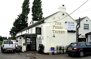
Penketh is a civil parish and suburb of Warrington in the Borough of Warrington, Cheshire, England. It is located about 3 miles (4.8 km) west of Warrington town centre. It has a population of 8,699. It is in the historic county of Lancashire.

<span class="mw-page-title-main">Newton-le-Willows</span> Town in Merseyside, England

Newton-le-Willows is a market town in the Metropolitan Borough of St Helens, Merseyside, England. The population at the 2021 census was 24,642. Newton-le-Willows is on the eastern edge of St Helens, south of Wigan and north of Warrington.

<span class="mw-page-title-main">A57 road</span> Road in England

The A57 is a major road in England. It runs east from Liverpool to Lincoln via Warrington, Salford and Manchester, and then through the Pennines over the Snake Pass (between the high moorlands of Bleaklow and Kinder Scout), around the Ladybower Reservoir, through Sheffield and past Worksop. Between Liverpool and Glossop, the road has largely been superseded by the M62, M602 and M67 motorways. Within Manchester a short stretch becomes the Mancunian Way, designated A57(M).

<span class="mw-page-title-main">Norris Green</span> Human settlement in England

Norris Green is a suburb and ward of Liverpool, England, in the east of the city. At the 2001 Census it had a population of 17,784, which had fallen to 15,047 at the 2011 Census.

<span class="mw-page-title-main">Birchwood, Cheshire</span> Human settlement in England

Birchwood is a town and civil parish in the Borough of Warrington, Cheshire, England. The parish had a population of 10,614 at the 2021 census. Located originally in Lancashire, it was built as a new town in the 1970s. Birchwood is made up of three districts: Gorse Covert, Locking Stumps and Oakwood.

<span class="mw-page-title-main">Speke</span> Human settlement in England

Speke is a suburb of Liverpool. It is 7.7 miles (12.4 km) southeast of the city centre. Located near the widest part of the River Mersey, it is bordered by the suburbs of Garston and Hunts Cross, and nearby to Halewood, Hale Village, and Widnes. The rural area of Oglet borders its south.

<span class="mw-page-title-main">Mossley Hill</span> Human settlement in England

Mossley Hill is a suburb of Liverpool and a Liverpool City Council ward. Located approximately 3.5 miles south east of Liverpool City Centre, it is bordered by Aigburth, Allerton, Childwall, Garston and Wavertree. At the 2001 Census, the population was 12,650, increasing to 13,816 at the 2011 Census.

<span class="mw-page-title-main">Old Swan</span> Human settlement in England

Old Swan is an eastern neighbourhood of Liverpool, Merseyside, England, bordered by Knotty Ash, Stoneycroft, Broadgreen, Fairfield and Wavertree. At the 2011 Census, the population was 16,461.

<span class="mw-page-title-main">Burtonwood</span> Village in England

Burtonwood is a village in the civil parish of Burtonwood and Westbrook, in the Borough of Warrington, Cheshire, England. Within the boundaries of the historic county of Lancashire, the name Burtonwood is known worldwide as the location of the former RAF Station Burtonwood military camp. Burtonwood village itself is a few miles away from the site of the former station. The civil parish also includes Westbrook, which is a council ward and suburb of Warrington. According to the 2001 census, the population of the entire civil parish was 11,265.

<span class="mw-page-title-main">Culcheth</span> Village near Warrington, England

Culcheth is a village in the civil parish of Culcheth and Glazebury, Cheshire, England, six miles (10 km) north-east of Warrington.

<span class="mw-page-title-main">Sankey for Penketh railway station</span> Railway station in Cheshire, England

Sankey for Penketh railway station, also known as just Sankey, is a railway station in the west of Warrington, Cheshire, England, serving the Great Sankey, Penketh and Whittle Hall areas of the town. The station, and all trains serving it, are operated by Northern Trains. It is designated by English Heritage as a Grade II listed building.

Priestley Sixth Form and Community College is a sixth form college in Warrington, Cheshire, England. It also offers adult courses and professional training on another site, and is an associate college of the University of Salford. The college offers a range of courses, including AS/A2 Levels, BTECs, Advanced Diplomas, functional skills, and pre-university foundation courses.

Westbrook is a ward and suburb in north west Warrington, in the Warrington district, in the ceremonial county of Cheshire, England. Within the boundaries of the historic county of Lancashire, it forms part of the civil parish of Burtonwood and Westbrook, to part of which it gives its name. The main part of Westbrook was built in the early 1980s. There are new estates being developed, the newest (Chapelford) was started in 2001.

There are various modes of transport available in Warrington.

<span class="mw-page-title-main">Borough of Warrington</span> Unitary authority area in Cheshire, England

The Borough of Warrington is a unitary authority area with borough status in the ceremonial county of Cheshire, England. The borough is centred around the town of Warrington, and extends out into outlying villages of Lymm and Great Sankey and the town of Birchwood.

Burtonwood and Westbrook is a civil parish in the Borough of Warrington in Cheshire, England, northwest of the town of Warrington. It contains eight buildings that are recorded in the National Heritage List for England as designated listed buildings. The parish includes the village of Burtonwood, and Westbrook, a suburb of the town of Warrington; otherwise it is rural. The original Liverpool to Manchester railway line runs through the north of the parish, and provides it with its only Grade I listed structure, the Sankey Viaduct. The other listed buildings are a church, two country houses, a gatehouse, and four farmhouses.

<span class="mw-page-title-main">Warrington</span> Town in Cheshire, England

Warrington is an industrial town in the borough of the same name in Cheshire, England. The town sits on the banks of the River Mersey and is historically part of Lancashire. It is 19 miles (31 km) east of Liverpool, and 18 miles (29 km) west of Manchester.

References


    Whittle Hall Community Center GIS, Research and Consultation, Chief Executive's Unit Census (Summer 2008)

    Great Sankey Parish Council

    Adobe Acrobat PDF Format

    Html Version [ dead link ]

    Sankey Station at National Rail

    Whittle Hall Bus Timetable (pdf format) No.13 No.29

    Pictures

    Pond after winter snowfall

    Typical cul de sac

    Community Center