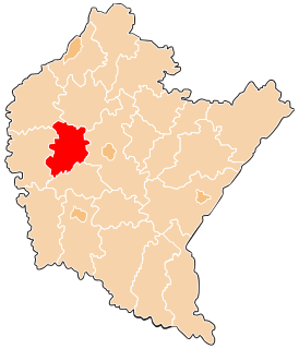
Gmina Sędziszów Małopolski is an urban-rural gmina in Ropczyce-Sędziszów County, Subcarpathian Voivodeship, in south-eastern Poland. Its seat is the town of Sędziszów Małopolski, which lies approximately 6 kilometres (4 mi) east of Ropczyce and 23 km (14 mi) west of the regional capital Rzeszów.
Gmina Wielopole Skrzyńskie is a rural gmina in Ropczyce-Sędziszów County, Subcarpathian Voivodeship, in south-eastern Poland. Its seat is the village of Wielopole Skrzyńskie, which lies approximately 16 kilometres (10 mi) south of Ropczyce and 30 km (19 mi) west of the regional capital Rzeszów.

Brzezówka is a village in the administrative district of Gmina Ropczyce, within Ropczyce-Sędziszów County, Subcarpathian Voivodeship, in south-eastern Poland. It lies approximately 7 kilometres (4 mi) west of Ropczyce and 33 km (21 mi) west of the regional capital Rzeszów.
Łączki Kucharskie is a village in the administrative district of Gmina Ropczyce, within Ropczyce-Sędziszów County, Subcarpathian Voivodeship, in south-eastern Poland. It lies approximately 11 kilometres (7 mi) south-west of Ropczyce and 32 km (20 mi) west of the regional capital Rzeszów.
Będzienica is a village in the administrative district of Gmina Iwierzyce, within Ropczyce-Sędziszów County, Subcarpathian Voivodeship, in south-eastern Poland. It lies approximately 4 kilometres (2 mi) south of Iwierzyce, 15 km (9 mi) south-east of Ropczyce, and 17 km (11 mi) west of the regional capital Rzeszów.
Bystrzyca is a village in the administrative district of Gmina Iwierzyce, within Ropczyce-Sędziszów County, Subcarpathian Voivodeship, in south-eastern Poland. It lies approximately 5 kilometres (3 mi) south-west of Iwierzyce, 13 km (8 mi) south-east of Ropczyce, and 20 km (12 mi) west of the regional capital Rzeszów.
Nockowa is a village in the administrative district of Gmina Iwierzyce, within Ropczyce-Sędziszów County, Subcarpathian Voivodeship, in south-eastern Poland. It lies approximately 3 kilometres (2 mi) south-east of Iwierzyce, 14 km (9 mi) south-east of Ropczyce, and 16 km (10 mi) west of the regional capital Rzeszów.
Olchowa is a village in the administrative district of Gmina Iwierzyce, within Ropczyce-Sędziszów County, Subcarpathian Voivodeship, in south-eastern Poland.
Olimpów is a village in the administrative district of Gmina Iwierzyce, within Ropczyce-Sędziszów County, Subcarpathian Voivodeship, in south-eastern Poland. It lies approximately 3 kilometres (2 mi) south-west of Iwierzyce, 12 km (7 mi) south-east of Ropczyce, and 19 km (12 mi) west of the regional capital Rzeszów.
Sielec is a village in the administrative district of Gmina Iwierzyce, within Ropczyce-Sędziszów County, Subcarpathian Voivodeship, in south-eastern Poland. It lies approximately 4 kilometres (2 mi) north-west of Iwierzyce, 9 km (6 mi) south-east of Ropczyce, and 20 km (12 mi) west of the regional capital Rzeszów.
Wiercany is a village in the administrative district of Gmina Iwierzyce, within Ropczyce-Sędziszów County, Subcarpathian Voivodeship, in south-eastern Poland. It lies approximately 3 kilometres (2 mi) south-west of Iwierzyce, 12 km (7 mi) south-east of Ropczyce, and 19 km (12 mi) west of the regional capital Rzeszów.
Skrzyszów is a village in the administrative district of Gmina Ostrów, within Ropczyce-Sędziszów County, Subcarpathian Voivodeship, in south-eastern Poland. It lies approximately 5 kilometres (3 mi) south-west of Ostrów, 7 km (4 mi) west of Ropczyce, and 33 km (21 mi) west of the regional capital Rzeszów.
Borek Wielki is a village in the administrative district of Gmina Sędziszów Małopolski, within Ropczyce-Sędziszów County, Subcarpathian Voivodeship, in south-eastern Poland. It lies approximately 5 kilometres (3 mi) north-west of Sędziszów Małopolski, 3 km (2 mi) north-east of Ropczyce, and 26 km (16 mi) west of the regional capital Rzeszów.
Góra Ropczycka is a village in the administrative district of Gmina Sędziszów Małopolski, within Ropczyce-Sędziszów County, Subcarpathian Voivodeship, in south-eastern Poland. It lies approximately 3 kilometres (2 mi) south-west of Sędziszów Małopolski, 6 km (4 mi) south-east of Ropczyce, and 24 km (15 mi) west of the regional capital Rzeszów.
Kawęczyn Sędziszowski is a village in the administrative district of Gmina Sędziszów Małopolski, within Ropczyce-Sędziszów County, Subcarpathian Voivodeship, in south-eastern Poland. It lies approximately 3 kilometres (2 mi) east of Sędziszów Małopolski, 8 km (5 mi) east of Ropczyce, and 20 km (12 mi) west of the regional capital Rzeszów.
Klęczany is a village in the administrative district of Gmina Sędziszów Małopolski, within Ropczyce-Sędziszów County, Subcarpathian Voivodeship, in south-eastern Poland. It lies approximately 7 kilometres (4 mi) east of Sędziszów Małopolski, 12 km (7 mi) east of Ropczyce, and 16 km (10 mi) west of the regional capital Rzeszów.
Krzywa is a village in the administrative district of Gmina Sędziszów Małopolski, within Ropczyce-Sędziszów County, Subcarpathian Voivodeship, in south-eastern Poland. It lies approximately 5 kilometres (3 mi) north-east of Sędziszów Małopolski, 8 km (5 mi) east of Ropczyce, and 21 km (13 mi) west of the regional capital Rzeszów.
Wolica Ługowa is a village in the administrative district of Gmina Sędziszów Małopolski, within Ropczyce-Sędziszów County, Subcarpathian Voivodeship, in south-eastern Poland. It lies approximately 2 kilometres (1 mi) north-east of Sędziszów Małopolski, 6 km (4 mi) east of Ropczyce, and 22 km (14 mi) west of the regional capital Rzeszów.
Wolica Piaskowa is a village in the administrative district of Gmina Sędziszów Małopolski, within Ropczyce-Sędziszów County, Subcarpathian Voivodeship, in south-eastern Poland. It lies approximately 2 kilometres (1 mi) north-east of Sędziszów Małopolski, 6 km (4 mi) east of Ropczyce, and 22 km (14 mi) west of the regional capital Rzeszów.
Zagorzyce is a village in the administrative district of Gmina Sędziszów Małopolski, within Ropczyce-Sędziszów County, Subcarpathian Voivodeship, in south-eastern Poland. It lies approximately 6 kilometres (4 mi) south of Sędziszów Małopolski, 8 km (5 mi) south-east of Ropczyce, and 24 km (15 mi) west of the regional capital Rzeszów.