Related Research Articles

Svalbard ( SVAHL-bar, Urban East Norwegian: [ˈsvɑ̂ːɫbɑr]; previously known as Spitsbergen, or Spitzbergen, is a Norwegian archipelago in the Arctic Ocean. Situated north of mainland Europe, it is about midway between the northern coast of Norway and the North Pole. The islands of the group range from 74° to 81° north latitude, and from 10° to 35° east longitude. The largest island is Spitsbergen, followed by Nordaustlandet and Edgeøya, and the largest settlement is Longyearbyen.

Longyearbyen is the largest settlement and the administrative centre of Svalbard, Norway. It stretches along the foot of the left bank of the Longyear Valley and on the shore of Adventfjorden, the short estuary leading into Isfjorden on the west coast of Spitsbergen, the island's broadest inlet. Since 2002 Longyearbyen Community Council has had many of the same responsibilities as a Norwegian municipality, including utilities, education, cultural facilities, fire brigade, roads and ports. The town is the seat of the Governor of Svalbard. It is the world's northernmost settlement of any kind with more than 1,000 permanent residents. Since 2015 Arild Olsen has served as Mayor.

Ny-Ålesund is a small town in Oscar II Land on the island of Spitsbergen in Svalbard, Norway. It is situated on the Brøgger peninsula (Brøggerhalvøya) and on the shore of the bay of Kongsfjorden. The company town is owned and operated by Kings Bay, which provides facilities for permanent research institutes from ten countries. The town is ultimately owned by the Ministry of Climate and Environment and is not incorporated. Ny-Ålesund has an all-year permanent population of 30 to 35, with the summer population reaching 120. Its facilities include Ny-Ålesund Airport, Hamnerabben, Svalbard Rocket Range, a port and Ny-Ålesund Town and Mine Museum, as well as fifteen permanent research stations. It is the northernmost functional civilian settlement in the world.
Barentsøya, sometimes anglicized as Barents Island, is an island in the Svalbard archipelago of Norway, lying between Edgeøya and Spitsbergen. Barents Island has no permanent human inhabitants. Named for the Dutch explorer Willem Barents, it is a part of Søraust-Svalbard Nature Reserve.
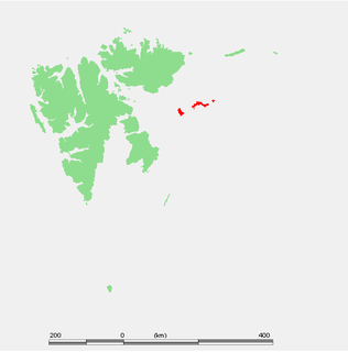
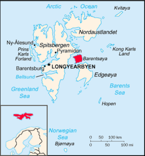
Kongsøya is an island in Svalbard, Norway. It is the largest of the islands in King Charles Land. Its area is 191 square kilometres (74 sq mi). The other main island in the chain is Svenskøya.
Braganzavågen is a bay located in the inner northern branch of Van Mijenfjorden, at Spitsbergen, Svalbard, within Heer Land and Nordenskiöld Land. The valley Kjellströmdalen debouches into the bay. The mining settlement Sveagruva is located at the western side of Braganzavågen, below the mountain Liljevalchfjellet.
Reindalselva is a river in Nordenskiöld Land at Spitsbergen, Svalbard. The river flows through the valley of Reindalen, starting from the mountain pass Reindalspasset, and ending into the bay Kaldbukta in Van Mijenfjorden. It has created one of Svalbard's largest river deltas. Among its tributary rivers are Semmeldalselva and Tverrdalselva.

Fridtjovbreen is a glacier in Nordenskiöld Land at Spitsbergen, Svalbard. It has a length of about 14 kilometers, and debouches into the bay Fridtjovhamna at the northern side of Van Mijenfjorden. The name stems from a hunting vessel used during the Torell expedition to Spitsbergen. The lower part of the glacier is included in the Nordenskiöld Land National Park.
Tinayrebukta is a bay in Haakon VII Land at Spitsbergen, Svalbard. It is located at the east side of Möllerfjorden, and is surrounded by the mountains of Fallièresfjella and Generalfjella. The glacier of Tinayrebreen debouches into the bay. The bay is named after French painter Jean Paul Louis Tinayre.
Fallièresfjella is a mountain group in Haakon VII Land at Spitsbergen, Svalbard. It is located north of the bay of Tinayrebukta and the glacier of Tinayrebreen. The highest peak reaches a height of 1,039 m.a.s.l., and the mountain group has an extension of about six kilometers. The mountain group is named after French politician Armand Fallières.
Generalfjella is a mountain group in Haakon VII Land at Spitsbergen, Svalbard. It is located east of Krossfjorden, between the bay of Tinayrebukta and the glacier of D'Arodesbreen. The mountain group is named after Norwegian army general Ole Hansen.
Ytterdalen is a valley in Nordenskiöld Land at Spitsbergen, Svalbard. It has a length of about nine kilometers, and is located between the mountains of Flynibba, Grånutane, Ytterdalsegga, Ytterdalssåta, Skarkampen and Salen. The river of Ytterdalselva from the glacier of Erdmannbreen flows through the valley, and further crosses Lågnesflya on its way to the bay of Van Muydenbukta.
Skarkampen is a mountain in Nordenskiöld Land at Spitsbergen, Svalbard. It has a height of 621 m.a.s.l. and is located between the plain of Lågnesflya and the valley of Ytterdalen. The mountain pass of Ytterskaret separates Skarkampen from the mountain of Ytterdalssåta further south.
Dunérbukta is a bay at the western shore of Storfjorden in Sabine Land at Spitsbergen, Svalbard. It is named after Swedish astronomer Nils Christoffer Dunér. The glacier of Ulvebreen debouches into the bay. At the northern side of the bay is the mountain of Domen and the ridge Kapp Johannesen.
Hayesbreen is a glacier in Sabine Land at Spitsbergen, Svalbard. It is named after American politician and Arctic explorer Isaac Israel Hayes. The glacier has a length of about eighteen kilometers, and debouches into the bay of Mohnbukta. Surrounding mountains are Aagaardfjellet to the north, Jebensfjellet to the south, and Panofskyfjellet where Hayesbreen joins the glacier of Königsbergbreen.
Mohnbukta is a bay at the western shore of Storfjorden in Sabine Land at Spitsbergen, Svalbard. It is named after Norwegian meteorologist Henrik Mohn. The glacier of Hayesbreen is situated northwest of the bay. At the western side of the bay is the mountain of Kroghfjellet, and north of the bay is the mountain of Teistberget.
Wichefjellet is a mountain in Sabine Land at Spitsbergen, Svalbard. It is named after English merchant and ship owner Richard Wiche. The mountain belongs to the mountain group of Hahnfjella, and is situated west of the bay of Wichebukta.
Hahnfjella is a mountain group in Sabine Land at Spitsbergen, Svalbard, west of the bay of Wichebukta. It is named after German geographer Friedrich Gustav Hahn. The highest mountain of the group reaches 537 m.a.s.l.
Svalisbreen is a glacier in Sørkapp Land at Spitsbergen, Svalbard. It has a length of about 12.5 kilometers, extending from the mountain pass of Svanhildpasset to Hornbreen, towards the bay of Brepollen, the inner part of Hornsund.
Paulabreen is a glacier in Nathorst Land and Heer Land at Spitsbergen, Svalbard. It has a length of about fifteen kilometers, extending from the mountain of Kjølberget to the bay of Rindersbukta. The glacier is named after Paula, the wife of shipmaster Richard Ritter von Barry. Paulabreen borders to the mountain area of Vriompeisen, and the mountain of Hollertoppen. A tributary glacier is Bakaninbreen.
References
- ↑ "Wichebukta (Svalbard)". Norwegian Polar Institute . Retrieved 10 June 2014.
- ↑ "Wichefjellet (Svalbard)". Norwegian Polar Institute . Retrieved 10 June 2014.
| This Spitsbergen location article is a stub. You can help Wikipedia by expanding it. |