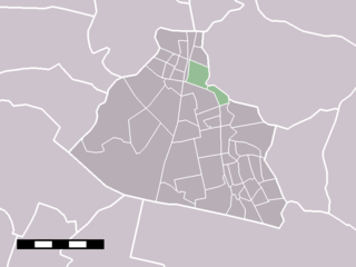
Wieldrecht

Last updated
Wieldrecht
Wapen-Wieldrecht-gem.jpg
Coat of arms
Map NL Dordrecht - Wieldrecht.PNG
Country Netherlands
Province Zuid-Holland
Municipality Dordrecht
Population 163 (CBS, 1 January 2,007)
Coat of arms of the former municipality Wapen-Wieldrecht-gem.jpg
Coat of arms of the former municipality
Location of Wieldrecht in Dordrecht Map NL Dordrecht - Wieldrecht.PNG
Location of Wieldrecht in Dordrecht

Wieldrecht is a small village in the Dutch province of South Holland. It is located about 4 km southwest of the city of Dordrecht, on the Kil River.

Netherlands Constituent country of the Kingdom of the Netherlands in Europe

The Netherlands is a country located mainly in Northwestern Europe. The European portion of the Netherlands consists of twelve separate provinces that border Germany to the east, Belgium to the south, and the North Sea to the northwest, with maritime borders in the North Sea with Belgium, Germany and the United Kingdom. Together with three island territories in the Caribbean Sea—Bonaire, Sint Eustatius and Saba— it forms a constituent country of the Kingdom of the Netherlands. The official language is Dutch, but a secondary official language in the province of Friesland is West Frisian.

South Holland Province of the Netherlands

South Holland is a province of the Netherlands with a population of just over 3.6 million as of 2015 and a population density of about 1,300/km2 (3,400/sq mi), making it the country's most populous province and one of the world's most densely populated areas. Situated on the North Sea in the west of the Netherlands, South Holland covers an area of 3,403 km2 (1,314 sq mi), of which 585 km2 (226 sq mi) is water. It borders North Holland to the north, Utrecht and Gelderland to the east, and North Brabant and Zeeland to the south. The provincial capital is The Hague, while its largest city is Rotterdam.

Dordrecht City and municipality in South Holland, Netherlands

Dordrecht, colloquially Dordt, historically in English named Dort, is a city and municipality in the Western Netherlands, located in the province of South Holland. It is the fourth-largest city of the province, with a population of 118,450. The municipality covers the entire Dordrecht Island, also often called Het Eiland van Dordt, bordered by the rivers Oude Maas, Beneden Merwede, Nieuwe Merwede, Hollands Diep, and Dordtsche Kil. Dordrecht is the largest and most important city in the Drechtsteden and is also part of the Randstad, the main conurbation in the Netherlands. Dordrecht is the oldest city in Holland and has a rich history and culture.

Wieldrecht was a separate municipality between 1817 and 1857, when it became part of Dubbeldam. [1]

Dubbeldam Former village and municipality in Zuid-Holland, Netherlands

Dubbeldam is a former village in the Dutch province of South Holland. It was located to the east of the city of Dordrecht. It is now a part of that city.

Related Research Articles

Steenwijk City in Overijssel, Netherlands

Steenwijk is a city in the Dutch province of Overijssel. It is located in the municipality of Steenwijkerland. It is the largest town of the municipality.

Wormerveer Place in Noord-Holland, Netherlands

Wormerveer is a town in the Dutch province of North Holland. It is a part of the municipality of Zaanstad, and lies about 13 km northwest of Amsterdam.

Badhoevedorp Place in North Holland, Netherlands

Badhoevedorp is a town in the Dutch province of North Holland. It is a part of the municipality of Haarlemmermeer, and lies next to the Ringvaart around Haarlemmermeer at the side of the polder bordering Amsterdam / Amstelveen.

Dodewaard Place in Gelderland, Netherlands

Dodewaard is a town in the Dutch province of Gelderland. It is a part of the municipality of Neder-Betuwe, and lies about 7 km south of Wageningen.

Sint Pancras is a town in the northwestern Netherlands. It is located in the municipality of Langedijk, North Holland, about 5 km northeast of Alkmaar.

Loenen en Wolferen is a former municipality in the Dutch province of Gelderland. It existed from 1818 to 1854, when it became a part of Valburg. The area is now part of the municipality of Overbetuwe.

Emmikhoven is a former village in the Dutch province of North Brabant. It was located just south of Almkerk, on the other side of the small river Alm, and is now a part of that village.

Giessen, Netherlands Village in North Brabant, Netherlands

Giessen is a village in the Dutch province of North Brabant. It is located in the municipality of Woudrichem, about 7 km southeast of Gorinchem.

Hofwegen is a hamlet in Molenwaard, which is a municipality in the Dutch province of South Holland. It is located on the south bank of the small river Graafstroom. It is now considered to be part of the village of Bleskensgraaf, which lies on the opposite bank.

Westmaas farm village in the Netherlands

Westmaas is a village in the Dutch province of South Holland. It is located about 14 km south of the city of Rotterdam, next to Mijnsheerenland in the municipality of Binnenmaas.

Kleine Elster (Niederlausitz)

Kleine Elster (Niederlausitz) is an Amt in the district of Elbe-Elster, in Brandenburg, Germany. Its seat is in Massen-Niederlausitz.

Lubieszów, Nowa Sól County Village in Lubusz, Poland

Lubieszów is a village in the administrative district of Gmina Nowa Sól, within Nowa Sól County, Lubusz Voivodeship, in western Poland. It lies approximately 5 kilometres (3 mi) west of Nowa Sól and 21 km (13 mi) south-east of Zielona Góra.

Snopki Village in Warmian-Masurian, Poland

Snopki is a village in the administrative district of Gmina Pisz, within Pisz County, Warmian-Masurian Voivodeship, in northern Poland. It lies approximately 4 kilometres (2 mi) north of Pisz and 86 km (53 mi) east of the regional capital Olsztyn.

Kaloré is a municipality in the state of Paraná in the Southern Region of Brazil.

Dematti is a village in Belgaum district in the southern state of Karnataka, India.

Greup is a small village on a dike in the Dutch province of South Holland. The village partially lies in the municipality of Binnenmaas and partly in the municipality of Oud-Beijerland. Greup is largely part of Mijnsheerenland.

Maasdijk is a hamlet in the Dutch province of South Holland and is part of the municipality Binnenmaas. Maasdijk lies north west of Westmaas on the road to Reedijk.

References

  1. Ad van der Meer and Onno Boonstra, "Repertorium van Nederlandse gemeenten", KNAW, 2006.

Coordinates: 51°47′N4°39′E / 51.783°N 4.650°E / 51.783; 4.650

Geographic coordinate system Coordinate system

A geographic coordinate system is a coordinate system that enables every location on Earth to be specified by a set of numbers, letters or symbols. The coordinates are often chosen such that one of the numbers represents a vertical position and two or three of the numbers represent a horizontal position; alternatively, a geographic position may be expressed in a combined three-dimensional Cartesian vector. A common choice of coordinates is latitude, longitude and elevation. To specify a location on a plane requires a map projection.