
Bavaria, officially the Free State of Bavaria, is a state in the south-east of Germany. With an area of 70,550.19 km2 (27,239.58 sq mi), Bavaria is the largest German state by land area, comprising roughly a fifth of the total land area of Germany. With over 13 million inhabitants, it is second in population only to North Rhine-Westphalia, but due to its large size its population density is below the German average. Bavaria's main cities are Munich, Nuremberg, and Augsburg.

Swabia is one of the seven administrative regions of Bavaria, Germany.
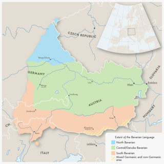
Bavarian is a West Germanic language variety variously described as a dialect of German or as a language in its own right, spoken in parts of Bavaria and most of Austria. Before 1945, Bavarian was also prevalent in parts of the southern Czech Republic and western Hungary. Bavarian forms a continuum of more or less mutually intelligible local and regional variants. Its mutual intelligibility with Standard German is very limited, but most of its speakers can code-switch to Standard German.

Upper Bavaria is one of the seven administrative districts of Bavaria, Germany.

Lower Bavaria is one of the seven administrative regions of Bavaria, Germany, located in the east of the state.
The Upper Palatinate is one of the seven administrative districts of Bavaria, Germany, and is located in the east of Bavaria.
Altötting is a Landkreis (district) in Bavaria, Germany. It is bounded by Austria and the Bavarian districts of Traunstein, Mühldorf and Rottal-Inn.
Freyung-Grafenau is a Landkreis (district) in Bavaria, Germany. It is bounded by the districts of Passau, Deggendorf and Regen, the Czech Republic and by Austria.

The Bavarian Alps is a collective name for several mountain ranges of the Northern Limestone Alps within the German state of Bavaria.

Bavarians are an ethnographic group of Germans of the Bavaria region, a state within Germany. The group's dialect or speech is known as the Bavarian language, native to Altbayern, roughly the territory of the Electorate of Bavaria in the 17th century.

Central Bavarian form a subgroup of Bavarian dialects in large parts of Austria and the German state of Bavaria along the Danube river, on the northern side of the Eastern Alps. They are spoken in the 'Old Bavarian' regions of Upper Bavaria, Lower Bavaria and in the adjacent parts of the Upper Palatinate region around Regensburg, in Upper and Lower Austria, in Vienna, in the state of Salzburg, as well as in the northern and eastern parts of Styria and Burgenland.
The Duchy of Bavaria was a frontier region in the southeastern part of the Merovingian kingdom from the sixth through the eighth century. It was settled by Bavarian tribes and ruled by dukes (duces) under Frankish overlordship. A new duchy was created from this area during the decline of the Carolingian Empire in the late ninth century. It became one of the stem duchies of the East Frankish realm which evolved as the Kingdom of Germany and the Holy Roman Empire.
The Kingdom of Bavaria was a German state that succeeded the former Electorate of Bavaria in 1805 and continued to exist until 1918. With the unification of Germany into the German Empire in 1871, the kingdom became a federated state of the new empire and was second in size, power, and wealth only to the leading state, the Kingdom of Prussia.
Southern Germany as a region has no exact boundary but is generally taken to include the areas in which Upper German dialects are spoken. This corresponds roughly to the historical stem duchies of Bavaria and Swabia or, in a modern context, to Bavaria and Baden-Württemberg within the Federal Republic of Germany, to the exclusion of the areas of the modern states of Austria and Switzerland. The Saarland and the southern parts of Hesse and Rhineland-Palatinate are sometimes included as well and correspond to the historical Franconia.

Waldsassen is a town in the district of Tirschenreuth in the Upper Palatinate region of Bavaria.
The Royal Bavarian Eastern Railway Company or Bavarian Ostbahn was founded in 1856. Within just two decades it built an extensive railway network in the eastern Bavarian provinces of Upper Palatinate (Oberpfalz) and Lower Bavaria (Niederbayern) that had previously been largely undisturbed by the railway. Much of this network is still important for local and long distance rail traffic operated by the Deutsche Bahn today.

Bavarian branch lines comprised nearly half the total railway network in Bavaria, a state in the southeastern Germany that was a kingdom in the days of the German Empire. The construction era for branch lines lasted from 1872, when the first route, from Siegelsdorf to Langenzenn, was opened, to 1930, when the last section of the branch from Gößweinstein to Behringersmühle went operational.

The Weiden–Oberkotzau railway is a two-track main line railway in Bavaria, Germany. It connects with the Regensburg–Weiden railway in Weiden in der Oberpfalz and runs via Marktredwitz to Oberkotzau, where it joins the Bamberg–Hof railway. The line forms part of a long-distance route from Munich to Hof, continuing to Leipzig and Dresden.
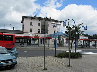
Marktredwitz station is the station of the major district town of Marktredwitz in the Bavarian administrative region of Upper Franconia. Two main lines, the Nuremberg–Cheb railway and the Weiden–Oberkotzau railway, cross at the station. It is classified by Deutsche Bahn as a category 3 station and has five platform tracks.
Wiesau is a municipality in Bavaria, Germany.