Aichach-Friedberg is a Landkreis (district) in Bavaria, Germany. It is bounded by the districts of Augsburg, Donau-Ries, Neuburg-Schrobenhausen, Pfaffenhofen, Dachau, Fürstenfeldbruck and Landsberg, as well as by the city of Augsburg.

Upper Bavaria is one of the seven administrative districts of Bavaria, Germany.

The Lech is a river in Austria and Germany. It is a right tributary of the Danube 255 kilometres (158 mi) in length with a drainage basin of 3,919 square kilometres (1,513 sq mi). Its source is located in the Austrian state of Vorarlberg, where the river rises from lake Formarinsee in the Alps at an altitude of 1,870 metres (6,120 ft). It flows in a north-north-easterly direction and crosses the German border, forming the Lechfall, a 12-metre-high (39 ft) waterfall; afterwards the river enters a narrow gorge. Leaving the Alps, it enters the plains of the Allgäu at Füssen at an elevation of 790 metres (2,580 ft) in the German state of Bavaria, where it used to be the location of the boundary with Swabia. The river runs through the city of Füssen and through the Forggensee, a man-made lake which is drained in winter. Here, it forms rapids and a waterfall.
Landsberg is a Landkreis (district) in Bavaria, Germany. It is bounded by the districts of Aichach-Friedberg, Fürstenfeldbruck, Starnberg, Weilheim-Schongau, Ostallgäu and Augsburg.

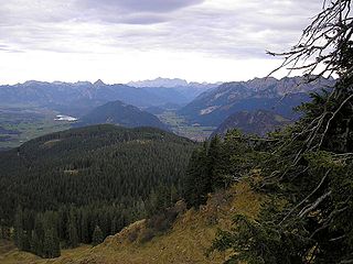
Bavarian Alps is a summarizing term of several mountain ranges of the Northern Limestone Alps in the German state of Bavaria.

The Duchy of Bavaria was a frontier region in the southeastern part of the Merovingian kingdom from the sixth through the eighth century. It was settled by Bavarian tribes and ruled by dukes (duces) under Frankish overlordship. A new duchy was created from this area during the decline of the Carolingian Empire in the late ninth century. It became one of the stem duchies of the East Frankish realm which evolved as the Kingdom of Germany and the Holy Roman Empire.

The Paar is a river of Bavaria, Germany, a right tributary of the Danube. For several tens of kilometers it flows parallel to the Lech, at only a few km distance. Near Augsburg, the Paar leaves the Lech valley and turns north-east towards Ingolstadt. It flows into the Danube near Vohburg. Towns and municipalities along the Paar include Egling, Mering, Aichach, Schrobenhausen and Manching.
Mering is a municipality in the district Aichach-Friedberg, in Bavaria, Germany. It is located on the river Paar.

Thierhaupten is a market town in south-central Germany in the district of Augsburg (district) in the Swabia administrative region of Bavaria, and is located at the Lech Valley.

The Schmutter is a river in Bavaria, Germany, a right tributary of the Danube.

The Wertach is a river in Bavaria, southern Germany, a left tributary of the Lech. Its total length is 141 km (88 mi). The Wertach originates in the Northern Limestone Alps in Bad Hindelang, east of Sonthofen. It flows north along the towns Wertach, Nesselwang, Marktoberdorf, Kaufbeuren, Schwabmünchen and Bobingen. The Wertach flows into the Lech in Augsburg.

The Friedberger Ach is a river in Bavaria, Germany. It is a right tributary of the Danube. Its source is in the village Untermühlhausen, northeast of Landsberg am Lech. For most of its length it flows parallel to the river Lech at only a few km distance. Towns along the Friedberger Ach include Weil, Prittriching, Mering, Friedberg, Rehling, Thierhaupten and Rain. After Rain, the Friedberger Ach flows east, parallel to the Danube, and joins the Danube near Oberhausen.

Münster is a municipality in the district of Donau-Ries in Bavaria in Germany.

The Battle of Pfaffenhofen was fought on 15 April 1745 between France and Austria. The Austrians under Karl Josef Batthyány defeated the outnumbered French under General Ségur, ending the war in Bavaria.
The Vils is a 36 km (22 mi) long river, a tributary of the Lech in the Alps of Austria and Germany. The Vils has a drainage basin of approximately a 200 km2 (77 sq mi), with an average annual precipitation of nearly 2,000 mm (80 in).

Halblech is a river of Bavaria, Germany. It flows into the Lech near Prem.

Schönach is a river of Bavaria, Germany. It is a left tributary of the Lech near Hohenfurch.

Illach is a river of Bavaria, Germany. It flows into the Lech near Steingaden.
Münsterer Alte is a river of Bavaria, Germany. It passes through Münster and flows into the Lech south of Rain.
The Bavarian Oberland is a region in Upper Bavaria north of and including the Bavarian Pre-alps between the rivers Lech and Inn.