
The Aare or Aar is a tributary of the High Rhine and the longest river that both rises and ends entirely within Switzerland.

Aarau is a town, a municipality, and the capital of the northern Swiss canton of Aargau. The town is also the capital of the district of Aarau. It is German-speaking and predominantly Protestant. Aarau is situated on the Swiss plateau, in the valley of the Aare, on the river's right bank, and at the southern foot of the Jura Mountains, and is west of Zürich, 58 kilometres (36 mi) south of Basel and 65 kilometres (40 mi) northeast of Bern. The municipality borders directly on the canton of Solothurn to the west. It is the largest town in Aargau. At the beginning of 2010 Rohr became a district of Aarau.

Aargau, more formally the Canton of Aargau, is one of the 26 cantons forming the Swiss Confederation. It is composed of eleven districts and its capital is Aarau.

The Rhine is one of the major European rivers. The river begins in the Swiss canton of Graubünden in the southeastern Swiss Alps. It forms the Swiss-Liechtenstein border and partly the Swiss-Austrian and Swiss-German borders. After that the Rhine defines much of the Franco-German border, after which it flows in a mostly northerly direction through the German Rhineland. Finally in Germany, the Rhine turns into a predominantly westerly direction and flows into the Netherlands where it eventually empties into the North Sea. It drains an area of 9,973 km2.

The geography of Switzerland features a mountainous and landlocked country located in Western and Central Europe. Switzerland's natural landscape is marked by its numerous lakes and mountains. It is surrounded by five countries: Austria and Liechtenstein to the east, France to the west, Italy to the south and Germany to the north. Switzerland has a maximum north–south length of 220 kilometres (140 mi) and an east–west length of about 350 kilometres (220 mi).

The Jura Mountains are a sub-alpine mountain range a short distance north of the Western Alps and mainly demarcate a long part of the French–Swiss border. While the Jura range proper is located in France and Switzerland, the range continues as the Table Jura northeastwards through northern Switzerland and Germany.

The canton of Lucerne is a canton of Switzerland. It is located in the country's central, German-speaking part. The population of the canton is 416,347. As of 2007, the population included 57,268 foreigners, or about 15.8% of the total population. The cantonal capital is the city of Lucerne.

The Alpine Rhine Valley is a glacial alpine valley, formed by the Alpine Rhine, the part of the River Rhine between the confluence of the Anterior Rhine and Posterior Rhine at Reichenau and Lake Constance. It covers three countries, with sections of the river demarcating the borders between Austria and Switzerland and between Liechtenstein and Switzerland. The full length of the Alpine Rhine is 93.5 km.

The Battle of Sempach was fought on 9 July 1386, between Leopold III, Duke of Austria and the Old Swiss Confederacy. The battle was a decisive Swiss victory in which Duke Leopold and numerous Austrian nobles died. The victory helped turn the loosely allied Swiss Confederation into a more unified nation and is seen as a turning point in the growth of Switzerland.
The Reuss is a river in Switzerland. With a length of 164 kilometres (102 mi) and a drainage basin of 3,426 square kilometres (1,323 sq mi), it is the fourth largest river in Switzerland. The upper Reuss forms the main valley of the canton of Uri. The course of the lower Reuss runs from Lake Lucerne to the confluence with the Aare at Brugg and Windisch.

Gränichen is a municipality in the district of Aarau of the canton of Aargau in Switzerland.
The Fricktal is a region on Northwestern Switzerland, comprising the Laufenburg and Rheinfelden districts of the Swiss canton of Aargau. The region was known as Frickgau in the medieval period, ultimately from a Late Latin [regio] ferraricia, in reference to the iron mine located here in the Roman era, also transferred to the village of Frick as the main settlement.

The Swiss Plateau or Central Plateau is one of the three major landscapes in Switzerland, lying between the Jura Mountains and the Swiss Alps. It covers about 30% of the Swiss surface area, and is partly flat but mostly hilly. The average height is between 400 metres (1,300 ft) and 700 metres (2,300 ft) AMSL. It is by far the most densely populated region of Switzerland, the center of economy and important transportation.

High Rhine is the name of the part of the River Rhine between Lake Constance and the city of Basel, flowing in a general east-to-west direction and forming mostly the Germany–Switzerland border. It is the first of four named sections of the Rhine between Lake Constance and the river delta at the North Sea.
The Oberaargau is the region that encompasses the upper watershed of the Aar River in the canton of Bern in Switzerland. On the north, lie the Jura Mountains, and on the south the hills leading to the Emmental.
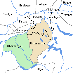
The Unteraargau is the lower watershed of the Aar River in the Swiss canton of Aargau.

The Kleine Emme is a river of the canton of Lucerne, Switzerland, a left tributary of the Reuss extending for 58 km, draining a basin of 477 km². It is not to be confused with the Emme of the canton of Bern. The Kleine Emme rises as the Waldemme in the southwestern corner of the canton of Obwalden, in the Brienzer Rothorn massif at the Emmensprung, flowing north-west along the Mariental, past Sörenberg. Turning north, it enters the Entlebuch region, where it is joined by the Weissemme near Schüpfheim and by the Entlen at Entlebuch. After receiving the Fontannen, it turns to the east at Wolhusen where it is joined by the Wigger and later by the Rümlig. From here, it flows parallel to the Pilatus chain, past Malters, joining the Reuss at Emmen, 2 km downstream of Lake Lucerne.
The Wyna is a river located mostly in canton of Aargau, but also in canton of Lucerne, Switzerland and runs through the Wynetal. It is a tributary of the Suhre. The Wyna is 32 km long. Larger towns in Wynetal are Beromünster, Menziken, Reinach (AG) and Gränichen.

The river Suhre is a 34 kilometer long tributary of the river Aare in the Swiss cantons of Lucerne and Aargau. The river rises in Sempachersee at an elevation of 504 meters above sea level, and joins the Aare east of the town Aarau at an elevation of 362 meters. The most important side valley is the Ruedertal, which joins the Suhretal at Schöftland.

The Aabach is a small river that runs through the Swiss cantons of Lucerne and Aargau, in the Aare catchment area. It flows from south to north through the valley called Seetal and ends in the Aare.
