
Dumfries and Galloway is one of 32 unitary council areas of Scotland and is located in the western Southern Uplands. It comprises the historic counties of Dumfriesshire, Kirkcudbrightshire, and Wigtownshire, the latter two of which are collectively known as Galloway. The administrative centre and largest settlement is the town of Dumfries. The second largest town is Stranraer, 75 miles to the west on the North Channel coast.

Wigtown is a town and former royal burgh in Wigtownshire, of which it is the county town, within the Dumfries and Galloway region in Scotland. It lies east of Stranraer and south of Newton Stewart. It is known as "Scotland's National Book Town" with a high concentration of second-hand book shops and an annual book festival.

Isle of Whithorn is one of the most southerly villages and seaports in Scotland, lying on the coast north east of Burrow Head, about three miles from Whithorn and about thirteen miles south of Wigtown in Dumfries and Galloway. Whithorn,, is a former royal burgh in Wigtownshire, Dumfries and Galloway, with which Isle of Whithorn is frequently incorrectly amalgamated or confused. It is referred to locally as 'The Isle' - never 'the Isle of Whithorn'.

Newton Stewart is a former burgh town in the historical county of Wigtownshire in Dumfries and Galloway, southwest Scotland. The town is on the River Cree with most of the town to the west of the river, and is sometimes referred to as the "Gateway to the Galloway Hills".
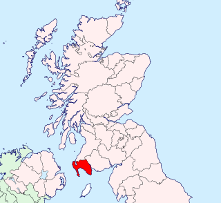
Wigtownshire or the County of Wigtown is a historic county, registration county and lieutenancy area in south-west Scotland. It is popularly known as and referred to as The Shire. Until 1975, Wigtownshire was one of the administrative counties used for local government purposes, and is now administered as part of the council area of Dumfries and Galloway. As a lieutenancy area, Wigtownshire has its own Lord Lieutenant, currently John Alexander Ross. In the 19th century, it was also called West Galloway. The county town was historically Wigtown, with the administrative centre moving to Stranraer, the largest town, on the creation of a county council in 1890.

The South of Scotland Football League (SoSFL) is a senior football league based in south-west Scotland. The league sits at level 6 on the Scottish football league system, acting as a feeder to the Lowland Football League.

The Bladnoch is a river in Wigtownshire in the Machars of Galloway in southwest Scotland. One of the earliest descriptions of it is given by Sir Andrew Agnew of Lochnaw and Sir David Dunbar in an appendix to Andrew Symson's work "A Large Description of Galloway" written in the 17th century. In this they state that:
Blaidzenoch which floweth from the mountnous parts of Penninghame, and runs from the north to the south. It runneth through Lochmabary, and by the way it receaveth into several waters; the most considerable is the water of Tarfe, which hath its rise from Airtfeeld, in the Muirs of Luce, and falleth into Blaidzenoch, under the house of Craighlaw. The Blaidzenoch turns to the east, and after it heth fra its source run twenty miles (32 km), it falleth into the Bay of Wigtown, near above the place of Baldone.

Newton Stewart Football Club are a football club from the town of Newton Stewart in the Dumfries and Galloway area of Scotland. Formed in 1880,as Newton Stewart Athletic but after a further two name changes they became Newton Stewart Football Club in 1902. They are nicknamed the Creesiders, because the town stands on the banks of the River Cree.

Wigtown & Bladnoch Football Club are a football club from the town of Wigtown in the Dumfries and Galloway area of Scotland, who play in the South of Scotland Football League, in the sixth tier of Scottish football.

The Underfall Yard is a historic boatyard on Spike Island serving Bristol Harbour in England.
Kirkcowan is an area about 15 miles in length, and from nearly two to nearly seven miles in breadth, comprising 30,580 acres, of which 7000 are arable, 300 woodland and plantations, and the remainder meadow, pasture in Machars, in the historical county of Wigtownshire, in Dumfries and Galloway, Scotland, with the village of Kirkcowan, bounded on the east by the river Bladnoch, on the west by the river Tarff, and is 6 miles W. by S.W. from Newton Stewart.
The River Cree is a river in Dumfries and Galloway, Scotland which runs through Newton Stewart and into the Solway Firth. It forms part of the boundary between the counties of Wigtownshire and Kirkcudbrightshire. The tributaries of the Cree are the Minnoch, Trool, Penkiln and Palnure which drain from the Range of the Awful Hand, the labyrinthine range of mountains and lochs, bogs, burns and crags, rising at its highest to The Merrick, Galloway, 12 miles north and visible from Newton Stewart.

Wigtown Bay is a large inlet of the Irish Sea on the coast of Galloway in southwest Scotland. Its coastline falls entirely within the modern administrative area of Dumfries and Galloway and shared between the historical counties of Wigtownshire and Kirkcudbrightshire.
Kirkinner is a village in the Machars, in the historical county of Wigtownshire in Dumfries and Galloway, Scotland. About 3 miles (4.8 km) southwest of Wigtown, it is bounded on the east by the bay of Wigtown, along which it extends for about three miles, and on the north by the river Bladnoch.
Penninghame in Wigtownshire, Dumfries and Galloway, Scotland, is a civil parish area, 8 miles from Wigtown. The area is approx 16 miles in length, and from 5 to 6 miles' width, bounded on the north and east by the River Cree, and on the west by the Bladnoch; comprising nearly 38,000 acres, of which 12,000 were arable, 600 woodland and plantations, 1600 meadow, and the remainder hill pasture, moorland, moss, etc.

Bladnoch is a small village on the River Bladnoch in Wigtownshire, Scotland, located just outside the county town of Wigtown.
Palnure railway station (NX450634) was a railway station on the Portpatrick and Wigtownshire Joint Railway close to Newton Stewart and the junction for the branch to Whithorn via Wigtown. It served the small village of Palnure in a rural area of the old county of Kirkcudbrightshire, Parish of Minnigaff, Dumfries And Galloway.
Mains of Penninghame Platform railway station (NX410617) was a halt on the Wigtownshire Railway branch line, from Newton Stewart to Whithorn, of the Portpatrick and Wigtownshire Joint Railway. It served a rural area of farms, including the large Mains of Pennighame and the nearby Clachan and old Kirk of Penninghame in the Parish of Penninghame, old Wigtownshire.

Kingholm Quay, commonly called the New Quay (NX975735) in the 19th century and its associated village and warehouses is located on the River Nith, once serving the town of Dumfries and its hinterland in Dumfries and Galloway. The port of Dumfries lay upstream and downstream quays were located at Laghall, Kelton, Glencaple, Carsethorn and Kirkconnell Jetty. It is not clear whether Kingholm was home to a fishing fleet of any sort. Mavisgrove Merse lay opposite.

Laghall Quay (NX973732) is located on the River Nith, once serving the estate of Laghall, later named Mavis Grove and now again called Laghall as well as its hinterland in Dumfries and Galloway, previously Kirkcudbrightshire. The ports of Dumfries, Kingholm Quay and Castledykes Quay lay upstream and downstream quays were located at Kelton, Glencaple, Carsethorn and Kirkconnell Jetty. It lies on the edge of the old Mavisgrove Merse.


