Wildhaus Pass

Last updated
Wildhaus Pass

Wildhauspass.jpg

Wildhaus Pass
Elevation 1,027 m (3,369 ft) [1]
Traversed by Road (1,090 m)
Location St. Gallen, Switzerland
Range Alps
Coordinates 47°12′12″N9°21′01″E / 47.2034°N 9.3504°E / 47.2034; 9.3504 Coordinates: 47°12′12″N9°21′01″E / 47.2034°N 9.3504°E / 47.2034; 9.3504
Switzerland relief location map.jpg
Red pog.svg
Wildhaus Pass
Location in Switzerland

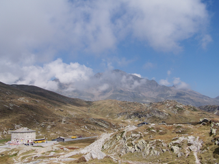
Wildhaus Pass is a high mountain pass in the Alps in the canton of St. Gallen in Eastern Switzerland. The main road culminates at 1,090 metres, while the pass itself lies at an elevation of 1,027 metres above sea level.

Mountain pass Route through a mountain range or over a ridge

A mountain pass is a navigable route through a mountain range or over a ridge. Since many of the world's mountain ranges have presented formidable barriers to travel, passes have played a key role in trade, war, and both human and animal migration throughout Earth's history. At lower elevations it may be called a hill pass. The highest vehicle-accessible pass in the world appears to be Mana Pass, located in the Himalayas on the border between India and Tibet, China.

Alps Major mountain range system in Central Europe

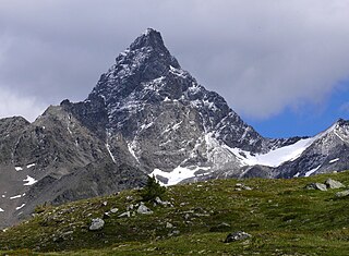
The Alps are the highest and most extensive mountain range system that lies entirely in Europe, separating Southern from Central and Western Europe and stretching approximately 1,200 kilometres (750 mi) across eight Alpine countries : France, Switzerland, Italy, Monaco, Liechtenstein, Austria, Germany, and Slovenia. The mountains were formed over tens of millions of years as the African and Eurasian tectonic plates collided. Extreme shortening caused by the event resulted in marine sedimentary rocks rising by thrusting and folding into high mountain peaks such as Mont Blanc and the Matterhorn. Mont Blanc spans the French–Italian border, and at 4,810 m (15,781 ft) is the highest mountain in the Alps. The Alpine region area contains about a hundred peaks higher than 4,000 metres (13,000 ft).

Eastern Switzerland Region in Switzerland

Eastern Switzerland is the common name of the region situated to the east of Glarus Alps, with the cantons of Schaffhausen, Thurgau, St. Gallen, Appenzell Ausserrhoden, Appenzell Innerrhoden, and Glarus. The north of canton of Graubünden is usually considered to be part of Eastern Switzerland as well.

It connects Gams in the Rhine valley and Unterwasser and Wattwil in the Toggenburg. The pass lies between the Säntis and the Churfirsten massifs. The pass road has a maximum grade of 12 percent.

Gams Place in St. Gallen, Switzerland

Gams is a municipality in the Wahlkreis (constituency) of Werdenberg in the canton of St. Gallen in Switzerland.

Rhine river in Western Europe

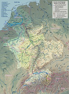
The Rhine is one of the major European rivers, which has its sources in Switzerland and flows in an mostly northerly direction through Germany and The Netherlands, emptying into the North Sea. The river begins in the Swiss canton of Graubünden in the southeastern Swiss Alps, forms part of the Swiss-Liechtenstein, Swiss-Austrian, Swiss-German and then the Franco-German border, then flows through the German Rhineland and the Netherlands and eventually empties into the North Sea.

Unterwasser is a village in the Toggenburg region of the canton of St. Gallen, Switzerland, situated at the confluence of the two streams forming the upper Thur. Formerly part of Wildhaus municipality, it has since 2010 been part of Wildhaus-Alt St. Johann by merger of Wildhaus and Alt St. Johann. It is a relatively small ski resort, and many of its trails are shared with nearby Wildhaus.

There is a ski resort at the summit in the municipality of Wildhaus.

Ski resort Resort developed for skiing, snowboarding, and other winter sports


A ski resort is a resort developed for skiing, snowboarding, and other winter sports. In Europe, most ski resorts are towns or villages in or adjacent to a ski area – a mountainous area with pistes and a ski lift system. In North America, it is more common for ski areas to exist well away from towns, so ski resorts usually are destination resorts, often purpose-built and self-contained, where skiing is the main activity.

Municipalities of Switzerland smallest government division in Switzerland

Municipalities are the lowest level of administrative division in Switzerland. Each municipality is part of one of the Swiss cantons, which form the Swiss Confederation. In most cantons municipalities are also part of districts or other sub-cantonal administrative divisions.

Wildhaus Former municipality of Switzerland in St. Gallen

Wildhaus is a village and former municipality in the Toggenburg region of the canton of St. Gallen in Switzerland, since 2010 by merger with Alt St. Johann part of the municipality of Wildhaus-Alt St. Johann.

See also

Related Research Articles

Swiss Alps portion of the Alps mountain range that lies within Switzerland

The Alpine region of Switzerland, conventionally referred to as the Swiss Alps, represents a major natural feature of the country and is, along with the Swiss Plateau and the Swiss portion of the Jura Mountains, one of its three main physiographic regions. The Swiss Alps extend over both the Western Alps and the Eastern Alps, encompassing an area sometimes called Central Alps. While the northern ranges from the Bernese Alps to the Appenzell Alps are entirely in Switzerland, the southern ranges from the Mont Blanc massif to the Bernina massif are shared with other countries such as France, Italy, Austria and Liechtenstein.

Tödi highest mountain in the Glarus Alps

The Tödi, is a mountain massif and with the mountain peak Piz Russein the highest mountain in the Glarus Alps and the highest summit in the canton of Glarus, Switzerland. It is located on the border between the cantons of Graubünden, to the south, and Glarus, to the north, close to the point where those two cantons meet the canton of Uri, to the west. Although not the culminating point of Graubünden, it is its highest peak outside the Bernina range.

This is a list of the extreme points of Europe: the geographical points that are higher or farther north, south, east or west than any other location in Europe. Some of these positions are open to debate, as the definition of Europe is diverse.

Gotthard Pass high mountain pass in Switzerland

The Gotthard Pass or St. Gotthard Pass at 2,106 m (6,909 ft) is a mountain pass in the Alps traversing the Saint-Gotthard Massif and connecting northern and southern Switzerland. The pass lies between Airolo in the Italian-speaking canton of Ticino, and Andermatt in the German-speaking canton of Uri, and connects further Bellinzona to Lucerne, Basel, and Zurich. The Gotthard Pass lies at the hearth of the Gotthard, an important north-south axis in Europe, and it is crossed by three major traffic tunnels, each being the world's longest at the time of their construction: the Gotthard Rail Tunnel (1882), the Gotthard Road Tunnel (1980) and the Gotthard Base Tunnel (2016). With the Lötschberg to the west, the Gotthard is one of the two main north-south routes through the Swiss Alps. Since the Middle Ages, transit across the Gotthard played an important role in Swiss history, the region north of Gotthard becoming the nucleus of the Swiss Confederacy in the early 14th century.

Grimsel Pass mountain pass across the Bernese Alps in Switzerland, between the Rhone valley and the Haslital

The Grimsel Pass is a mountain pass in Switzerland, crossing the Bernese Alps at an elevation of 2,164 metres (7,100 ft). The pass connects the Haslital, the upper valley of the river Aare, with the upper valley of the Rhône. In so doing, and as the Aare is a tributary of the Rhine, the pass crosses the continental divide between the North Sea and the Mediterranean Sea.

Bernina Pass mountain pass

The Bernina Pass is a high mountain pass in the Bernina Range of the Alps, in the canton of Graubünden (Grisons) in eastern Switzerland. It connects the famous resort town of St. Moritz in the Engadin valley with the Italian-speaking Val Poschiavo, which ends in the Italian town of Tirano in Valtellina. The pass lies a few kilometres east of Piz Bernina.

Nufenen Pass mountain pass in Switzerland linking the cantons of Valais and Ticino

Nufenen Pass is the highest mountain pass with a paved road within Switzerland. It lies between the summits of Pizzo Gallina (north) and the Nufenenstock (south).

Furka Pass mountain pass

Furka Pass, with an elevation of 2,429 metres (7,969 ft), is a high mountain pass in the Swiss Alps connecting Gletsch, Valais with Realp, Uri. The Furka Oberalp Bahn line through the Furka Tunnel bypasses the pass. The base tunnel opened in 1982 and replaced a tunnel at 2100 m.

Klausen Pass mountain pass in Switzerland, between Uri and Glarus cantons

Klausen Pass is a high mountain pass in the Swiss Alps connecting Altdorf in the canton of Uri with Linthal in the canton of Glarus. Somewhat unusually, the boundary between the two cantons does not lie at the summit of the pass, but some 8 kilometres (5.0 mi) down the slope towards Linthal, with the summit being in Uri.

Susten Pass mountain pass

Susten Pass is a mountain pass in the Swiss Alps. The pass road, built from 1938–1945, connects Innertkirchen in the canton of Bern with Wassen in the canton of Uri. A 300 metres long tunnel crosses the pass at 2,224 metres.

San Bernardino Pass mountain pass

San Bernardino Pass is a high mountain pass in the Swiss Alps connecting the Hinterrhein and the Mesolcina (Misox) valleys between Thusis and Bellinzona. Located in the far eastern side of the Western Alps it is not to be confused with the Great St Bernard Pass and the Little St Bernard Pass. The top of the pass represents both the Italo-German language frontier and the watershed between the Po basin and the Rhine basin.

Säntis peak in northeastern Switzerland

At 2,501.9 metres above sea level, Säntis is the highest mountain in the Alpstein massif of northeastern Switzerland. It is also the culminating point of the whole Appenzell Alps, between Lake Walen and Lake Constance. Shared by three cantons, the mountain is a highly visible landmark thanks to its exposed northerly position within the Alpstein massif. As a consequence, houses called Säntisblick can be found in regions as far away as the Black Forest in Germany. Säntis is among the most prominent summits in the Alps and the most prominent summit in Europe with an observation deck on the top. The panorama from the summit is spectacular. Six countries can be seen if the weather allows: Switzerland, Germany, Austria, Liechtenstein, France, and Italy.

Vue des Alpes mountain pass

Vue des Alpes is a high mountain pass in the Jura Mountains in the canton of Neuchâtel.

Piz Kesch mountain

Piz Kesch (German) or Piz d'Es-cha (Rumantsch) is a peak in the Albula Alps of the Rhaetian Alps in Switzerland. At 3,418 metres (11,214 ft), it is the highest peak in the Albula Alps and the municipality of Bergün, Grisons.

Les Agites mountain pass

Les Agites is a high mountain pass in the Alps in the canton of Vaud in Switzerland.

Schwyz Alps

The Schwyz Alps are a mountain range in Switzerland. They form part of the North-Eastern Swiss Alps and are bordered by the Glarus Alps to the east, the Appenzell Alps to the north-east, the Emmental Alps in the west, and the Uri Alps to the south-west. The Klausen Pass is the highest point between the Schwyz Alps and the Glarus Alps.

References

  1. Retrieved from the Swisstopo topographic maps