Related Research Articles

The Great Barrier Reef is the world's largest coral reef system, composed of over 2,900 individual reefs and 900 islands stretching for over 2,300 kilometres (1,400 mi) over an area of approximately 344,400 square kilometres (133,000 sq mi). The reef is located in the Coral Sea, off the coast of Queensland, Australia, separated from the coast by a channel 160 kilometres (100 mi) wide in places and over 61 metres (200 ft) deep. The Great Barrier Reef can be seen from outer space and is the world's biggest single structure made by living organisms. This reef structure is composed of and built by billions of tiny organisms, known as coral polyps. It supports a wide diversity of life and was selected as a World Heritage Site in 1981. CNN labelled it one of the Seven Natural Wonders of the World in 1997. Australian World Heritage places included it in its list in 2007. The Queensland National Trust named it a state icon of Queensland in 2006.

Cairns is a city in Queensland, Australia, on the tropical north east coast of Far North Queensland. The population as of the 2021 census was 169,312, having grown on average 1.02% annually over the preceding five years. The city is the 5th-most-populous in Queensland, and 15th in Australia.

The Coral Sea is a marginal sea of the South Pacific off the northeast coast of Australia, and classified as an interim Australian bioregion. The Coral Sea extends 2,000 kilometres (1,200 mi) down the Australian northeast coast. Most of it is protected by the French Natural Park of the Coral Sea and the Australian Coral Sea Marine Park. The sea was the location for the Battle of the Coral Sea, a major confrontation during World War II between the navies of the Empire of Japan, and the United States and Australia.

The Burdekin River is a river in North and Far North Queensland, Australia. The river rises on the northern slopes of Boulder Mountain at Valley of Lagoons, part of the western slope of the Seaview Range, and flows into the Coral Sea at Upstart Bay over 200 kilometres (124 mi) to the southeast of the source, with a catchment area of approximately 130,000 square kilometres (50,000 sq mi). The Burdekin River is Australia's largest river by (peak) discharge volume.

Heron Island is a coral cay located near the Tropic of Capricorn in the southern Great Barrier Reef, 80 kilometres north-east of Gladstone, Queensland, Australia, and 460 km (290 mi) north-north-west of the state capital Brisbane. The island is situated on the leeward (western) side of Heron Reef, a fringing platform reef of significant biodiversity, supporting around 900 of the 1,500 fish species and 72% of the coral species found on the Great Barrier Reef. During the summer months Heron Island is also home to over 200,000 birds including Noddy Terns and Mutton Birds.

Dorothy Hill, was an Australian geologist and palaeontologist, the first female professor at an Australian university, and the first female president of the Australian Academy of Science.

The Barron River is located on the Atherton Tablelands inland from Cairns in North Queensland, Australia. With its headwaters below Mount Hypipamee, the 165-kilometre (103 mi)-long river with a catchment area of approximately 2,138 square kilometres (825 sq mi) forms through run off from the Mount Hypipamee National Park, flows through Lake Tinaroo, and eventually empties into the Coral Sea near Smithfield.
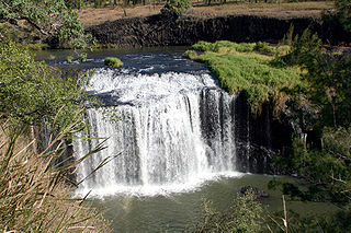
The Millstream Falls, a tiered plunge waterfall on The Millstream, is located in the UNESCO World Heritage–listed Wet Tropics in the Far North region of Queensland, Australia.

The Shire of Cardwell was a local government area of Queensland. It was located on the Coral Sea coast about halfway between the cities of Cairns and Townsville. The shire, administered from the town of Tully, covered an area of 3,062.2 square kilometres (1,182.3 sq mi), and existed as a local government entity from 1884 until 2008, when it amalgamated with the Shire of Johnstone to form the Cassowary Coast Region.

The Great Barrier Reef is the world's largest reef systems, stretching along the East coast of Australia from the northern tip down at Cape York to the town of Bundaberg, is composed of roughly 2,900 individual reefs and 940 islands and cays that stretch for 2,300 kilometres (1,616 mi) and cover an area of approximately 344,400 square kilometres (133,000 sq mi). The reef is located in the Coral Sea, off the coast of Queensland in northeast Australia. A large part of the reef is protected by the Great Barrier Reef Marine Park.
Hoskyn Islands is a pair of small coral cays. They are located near the Tropic of Capricorn in the southern Great Barrier Reef, 107 km due east of Gladstone, Queensland, Australia, and 412 km north of the state capital Brisbane.
Tryon Island is a coral cay located in the southern Great Barrier Reef, 86 km northeast of Gladstone, Queensland, Australia, and 465 km north of the state capital Brisbane. The island is a protected area and forms part of Capricornia Cays National Park. It is part of the Capricornia Cays Important Bird Area. The cay covers an area of 0.21 square kilometres and is surrounded by a coral reef that is partially exposed at low-tide.

The Mulgrave River, incorporating the East Mulgrave River and the West Mulgrave River, is a river system in Far North Queensland, Australia. The 70-kilometre (43 mi)-long river flows towards the Coral Sea and is located approximately 50 kilometres (31 mi) south of Cairns.

Wyborn Reef Light is an active lighthouse located at Wyborn Reef, formerly known as Y Reef, about 16 kilometres (9.9 mi) southeast of Albany Island, east of the tip of Cape York Peninsula, Queensland, Australia. It marks the entrance to the Albany Passage. The lighthouse was constructed in 1938 and upgraded in 1991 and 1995. The structure is a stainless steel tower with a fiberglass hut within the framework, carrying a lantern.

The Cairns Argus, from 1911 onward Cairns Daily Argus, was a [[[newspaper]] published from 1888 to 1918 in Cairns, Queensland, Australia.
Walter Heywood (W.H.) Bryan (1891–1966) was an Australian geologist, educator and decorated military veteran. He founded the University of Queensland Seismology Station, and was the first student at the University of Queensland to receive a Doctor of Science (D.Sc.) degree. He served with distinction during World War I.

Heron Island Research Station is a marine research station located on Heron Island, an island within the Great Barrier Reef Marine Park, 80 km from Gladstone, off the coast of Queensland, Australia. It is located at the leeward end of a coral cay on a 10 x 5 kilometre platform reef. Although the island had been used as a turtle cannery in the 1920s, after this was abandoned, it was taken over as a resort in the 1930s, by Captain Christian Poulsen. A number of researchers travelled to the island from the 1930s using the resort facilities. The island became a National Park in 1943, and following the end of World War II, saw the first groups of university students from the University of Queensland arrive. Today the island is divided into three sections - the resort, research station and National Park.
Edward Oswald Marks, was an Australian ophthalmologist. He studied first as a geologist, and then began a second career as an ophthalmologist. His work on preventing trachoma in children was significant in reducing eye disease in remote communities.

Robert Endean (1925–1997) was an Australian marine scientist and academic at the University of Queensland.
Blackheath and Thornburgh College is a primary and secondary (K-12) school with boarding facilities at 55 King Street, Richmond Hill, Charters Towers, Charters Towers Region, Queensland, Australia.
References
- ↑ "Newspaper Pioneer", The Telegraph (Brisbane), 28 July 1943, p. 4
- ↑ "North Queenslander's Success", Cairns Post, 1 August 1952, p. 5
- ↑ "Northern Student's Success. - Cairns Post (Qld. : 1909 - 1954) - 15 Jan 1949". Cairns Post. 15 January 1949. Retrieved 19 April 2017.
- ↑ "UQ celebrates 5000th PhD graduate". UQ News. Retrieved 19 April 2017.
- ↑ "North Queenslander's Success. - Cairns Post (Qld. : 1909 - 1954) - 1 Aug 1952". Cairns Post. August 1952. Retrieved 19 April 2017.
- ↑ Hill, Dorothy. "The first fifty years of the Department of Geology of the University of Queensland". Papers, Department of Geology, the University of Queensland. 10 (1): 41.
- ↑ Maxwell, William Graham Henderson (1964). "The Geology of the Yarrol Region.Part 1. Biostratigraphy" (PDF). Papers, Department of Geology, the University of Queensland. 5 (9): 1–81.
- ↑ "Geology faculty news" (PDF). Department of Geology University of Texas Newsletter. 13: 3. August 1964.
- ↑ Hopley, David, Smithers, Scott G. and Parnell, Kevin E. (2007). Geomorphology of the Great Barrier Reef: development, diversity and change . Cambridge University Press. pp. 12–13. ISBN 978-0-511-28524-0.
{{cite book}}: CS1 maint: multiple names: authors list (link) - ↑ Maxwell, W.G.H. (1968). Atlas of the Great Barrier Reef. Elsevier. pp. Acknowledgements.
- ↑ Kenchington, Richard A. (1 April 1978). "The Crown-of-thorns Crisis in Australia: A Retrospective Analysis" . Environmental Conservation. 5 (1): 11–20. Bibcode:1978EnvCo...5...11K. doi:10.1017/S0376892900005191. ISSN 1469-4387. S2CID 86566114.
- ↑ Cooper, B.J. and Branagan, D.F. (1994). Rock me hard, rock me soft. Geological Society of Australia. p. 98. ISBN 0909869898.
{{cite book}}: CS1 maint: multiple names: authors list (link)
| International | |
|---|---|
| National | |