Related Research Articles
Westwood may refer to:

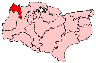
The Borough of Dartford is a local government district in the north-west of the county of Kent, England. Its council is based in the town of Dartford. It is part of the contiguous London urban area. It borders the borough of Gravesham to the east, Sevenoaks District to the south, the London Borough of Bexley to the west, and the Thurrock unitary authority in Essex to the north, across the River Thames. The borough was formed on 1 April 1974 by the merger of the Municipal Borough of Dartford, the Swanscombe Urban District, and part of the Dartford Rural District. According to the 2011 Census, its population was 97,365.

Swanscombe (/ˈswɒnzkəm/) is a village in the Borough of Dartford in Kent, England and the civil parish of Swanscombe and Greenhithe. It is located 4.4 miles west of Gravesend and 4.8 miles east of Dartford.

Northfleet is a town in the borough of Gravesham in Kent, England. It is located immediately west of Gravesend, and on the border with the Borough of Dartford. Northfleet has its own railway station on the North Kent Line, just east of Ebbsfleet International railway station on the High Speed 1 line.

Greenhithe is a town in the Borough of Dartford in Kent, England, and the civil parish of Swanscombe and Greenhithe. It is located 3+1⁄2 miles east of Dartford and 4+1⁄2 miles west of Gravesend.
Longfield is a village in the Borough of Dartford, Kent, England. It is located 6 miles south east of Dartford and the same distance south-west of Gravesend.
Southfleet is a small village and civil parish in the borough of Dartford in Kent, England. The village is located three miles southwest of Gravesend, while the parish includes within its boundaries the hamlets of Betsham and Westwood.
Dartford is a constituency represented in the House of Commons of the UK Parliament since 2010 by Gareth Johnson of the Conservative Party. The constituency is currently the longest-valid 'bellwether' constituency in the country as the party of the winning candidate has gone on to form the government at every UK general election since 1964. Candidates for the largest two parties nationally have polled first and second since 1923 in Dartford.

Fawkham Junction is a railway junction that currently connects High Speed 1 with the Kent Rail Network.
Dartford Borough Council is the local authority for the Borough of Dartford in Kent.
Dartford Rural District was a rural district with an area of 34,037 acres (138 km2) in the county of Kent, England. In 1971 it had a population of 64,561 and an electorate of 43,911. At dissolution it was the most populous rural district council in Kent, but had once been larger, having lost territory when Crayford Urban District was created in 1920, and Swanscombe Urban District in 1926.

New Barn is a compact residential area surrounded by open fields which lies four miles southwest of Gravesend in Kent, England. It is in the local government district of Dartford. The villages of New Barn and Longfield are within and give their names to the civil parish of Longfield and New Barn. New Barn is larger in population than Longfield, although has little in the way of services, being a recent development and purely residential in nature

Betsham is a hamlet in the parish of Southfleet in Kent, England.
The Gravesend West Line was a short railway line in Kent that branched off the Swanley to Chatham line at Fawkham Junction and continued for a distance of 5 miles (8 km) to Gravesend where the railway company constructed a pier to connect trains with steamers. It was opened in 1886 and closed to passenger services in 1953, remaining open to freight until 1968 before reopening briefly between 1972 and 1976. Part of the railway's former alignment was incorporated into the Channel Tunnel Rail Link.

There have been three baronetcies created for members of the Sedley family of Kent, all in the Baronetage of England. All three creations are extinct.
Southfleet was a railway station on the Gravesend West Line which served the small village of Southfleet in Kent, England.

Baker's Hole is a 6.9 hectares geological Site of Special Scientific Interest, mostly consisting of a back-filled quarry, adjacent to Ebbsfleet International railway station in Kent. It is a Geological Conservation Review site. It is a nationally significant site for finds during quarrying of Stone Age tools, which are now dispersed among many museums.

Axstane was a hundred in the county of Kent, England. The Hundred of Axstane lay south-east of Dartford and Wilmington Hundred. It is called Achestan in Domesday Book, but by the reign of Edward I it was called Axstane.
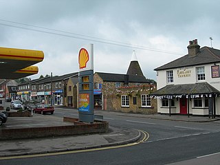
Westwood is a hamlet in the parish of Southfleet in Kent, England, in the west of the parish.
William Carter was an English cricketer who played in the mid-1840s.
References
- ↑ Hasted, Edward (1797). "'Parishes: Southfleet', in The History and Topographical Survey of the County of Kent". Canterbury. pp. 421–440. Retrieved 30 January 2022.
- ↑ Richardson, Douglas. Magna Carta Ancestry: A Study in Colonial and Medieval Families (2 ed.). p. 14.
| | This English biographical article is a stub. You can help Wikipedia by expanding it. |