Related Research Articles

Yerba Buena Island sits in San Francisco Bay within the borders of the City and County of San Francisco. The Yerba Buena Tunnel runs through its center and connects the western and eastern spans of the San Francisco–Oakland Bay Bridge,linking the city with Oakland,California. Treasure Island is connected by a causeway to Yerba Buena Island. According to the United States Census Bureau,Yerba Buena Island and Treasure Island together have a land area of 0.901 square miles (2.33 km2) with a total population of 2,500 as of the 2010 census.

The Battle of Monterey,at Monterey,California,occurred on 7 July 1846,during the Mexican–American War. The United States captured the town unopposed.

Samuel S. Brannan was an American settler,businessman,journalist,and prominent Mormon who founded the California Star,the first newspaper in San Francisco,California. He is also considered the first to publicize the California Gold Rush and was California's first millionaire. He used the profits from his stores to buy large tracts of real estate. He helped form the first vigilance committee in San Francisco and was disfellowshiped from the Church of Jesus Christ of Latter-day Saints because of his actions within the vigilance committee. Brannan's wife divorced him and he was forced to liquidate much of his real estate to pay her one-half of their assets. He died poor and in relative obscurity.

Californios are Hispanic Californians,especially those descended from Spanish and Mexican settlers of the 17th through 19th centuries. California's Spanish-speaking community has resided there since 1683 and is made up of varying Spanish and Mexican origins,including criollos,Mestizos,Indigenous Californian peoples,and small numbers of Mulatos. Alongside the Tejanos of Texas and Neomexicanos of New Mexico and Colorado,Californios are part of the larger Spanish-American/Mexican-American/Hispano community of the United States,which has inhabited the American Southwest and the West Coast since the 16th century. Some may also identify as Chicanos,a term that came about in the 1960s.

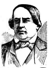
William Anthony Richardson was an early California entrepreneur,influential in the development of Yerba Buena,the forerunner of the city of San Francisco.
The history of the city of San Francisco,California,and its development as a center of maritime trade,were shaped by its location at the entrance to a large natural harbor. San Francisco is the name of both the city and the county;the two share the same boundaries. Only lightly settled by European-Americans at first,after becoming the base for the gold rush of 1849 the city quickly became the largest and most important population,commercial,naval,and financial center in the American West. San Francisco was devastated by a great earthquake and fire in 1906 but was quickly rebuilt. The San Francisco Federal Reserve Branch opened in 1914,and the city continued to develop as a major business city throughout the first half of the 20th century. Starting in the later half of the 1960s,San Francisco became the city most famous for the hippie movement. In recent decades,San Francisco has become an important center of finance and technology. The high demand for housing,driven by its proximity to Silicon Valley,and the limited availability has led to the city being one of America's most expensive places to live. San Francisco is currently ranked 16th on the Global Financial Centres Index.
Jasper O'Farrell (1817–1875) was an Irish-American politician who served as the first surveyor for San Francisco. He designed the "grand promenade" that became today's Market Street. O'Farrell Street in San Francisco is named after him.

Francisco de Haro was a Californio politician,soldier,and ranchero,who served as the 1st and 5th Alcalde of San Francisco. He notably commissioned the first land survey of San Francisco to Jean Jacques Vioget in 1839.

Washington Allon Bartlett was the first U.S. citizen to serve as alcalde of Yerba Buena/San Francisco,appointed by the military government during the Mexican-American War and serving from August 14,1846,to January 31,1847.

Yerba Buena was the original name of the settlement that later became San Francisco. Located near the northeastern end of the San Francisco Peninsula,between the Presidio of San Francisco and the Mission San Francisco de Asís,it was originally intended as a trading post for ships visiting San Francisco Bay. The settlement was arranged in the Spanish style around a plaza that remains as the present day Portsmouth Square.

JoséJoaquín Estudillo was a Californio statesman and ranchero who served as the 2nd Alcalde of San Francisco. A member of the prominent Estudillo family of California,he is also considered the founder of the city of San Leandro.

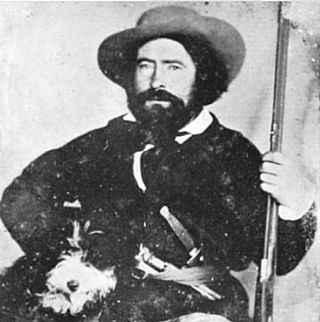
Jacob Primer Leese,known in Spanish as Don Jacobo Leese,was an Ohio-born Californian ranchero,entrepreneur,and public servant. He was an early resident of San Francisco and married into the family of prominent Californio statesman and general Mariano Guadalupe Vallejo,which elevated his rank in Californian society and allowed him to acquire several ranchos.
Joséde Jesús Noé was a Californio politician,soldier,and ranchero,who served as the 7th and 12th Alcalde of San Francisco. He is the last Hispanic Californian (Californio) to serve as Mayor of San Francisco.

The Battle of Santa Clara,nicknamed the "Battle of the Mustard Stalks",was a skirmish during the Mexican–American War,fought on January 2,1847,2+1⁄2 miles west of Mission Santa Clara de Asís in California.
Howard Street is a street in San Francisco's South of Market District (SoMa). It begins after branching off from Van Ness Avenue near the Mission District,and then runs parallel to and between of Mission Street and Folsom Street towards The Embarcadero. Howard Street has the Moscone Center,Rincon Plaza,Yerba Buena Center for the Arts,and The University of San Francisco along its corridor.

The Sonoma Barracks is a two-story,wide-balconied,adobe building facing the central plaza of the City of Sonoma,California. It was built by order of Mariano Guadalupe Vallejo to house the Mexican soldiers that had been transferred from the Presidio of San Francisco in 1835. The Presidio Company and their commander,Vallejo,were also responsible for controlling the Native Americans living on the northern border of Mexican California.

The Battle of Yerba Buena was an engagement during the Mexican–American War,during which the U.S. Navy captured and occupied the town of Yerba Buena,California,without firing a shot.

Yerba Buena Cove was a cove on San Francisco Bay where the Mexican town of Yerba Buena was located. It lay between Clarks Point to the north and Rincon Point to the south. The beach of the cove was set back as far as what is now Montgomery Street between Clay and Washington Streets.

Rancho Las Camaritas was an Alta California land grant,a square of 300 Mexican varas on each side;varas being one pace,in this case 2.75 feet to Joséde Jesús Noéon January 21,1840,by Governor Juan Bautista Alvarado. Millions of acres of California land was given at no charge to men between 1784 and 1846 by the Spanish (1784–1810) or Mexican governments (1819–1846) mostly for military service to raise cattle on. About 300 of the 800 Land grants were sizable varying from a few thousand to 1.5 million acres –see List of ranchos of California for the larger grants. Following the Mexican–American War,the land grants were challenged with most of them falling into American hands. Only one land grant has remained undeveloped. The ownership of Las Camaritas was disputed in court by the U.S. government from 1856 until 1882 due to conflicting documentation presented by its American owner Ferdinand Vassault after a string of sales initiated by Jose Noe sometime between 1842 and 1846.
The interim government of California existed from soon after the outbreak of the Mexican–American War in mid-1846 until U.S. statehood in September,1850. There were three distinct phases:
References
- 1 2 3 Davis, William Heath (1889). Sixty Years in California: A History of Events and Life in California; Personal, Political and Military, Under the Mexican Regime; During the Quasi-military Government of the Territory by the United States, and After the Admission of the State Into the Union, Being a Compilation by a Witness of the Events Described. A.J. Leary. pp. 205.
- ↑ Hart, James David (1987). "Hide trade of Mexican era". A Companion to California: Newly Revised and Expanded with Illustrations. University of California Press. p. 215. ISBN 9780520055438.
- ↑ Ogden, Adele (1975). The California Sea Otter Trade, 1784-1848. University of California Press. p. 178. ISBN 9780520028067.
- ↑ Atherton, Faxon Dean (1964). California Diary, 1836-1839 . California Historical Society. pp. 194.
- ↑ Egan, Ferol (1977). Frémont, Explorer for a Restless Nation. University of Nevada Press. p. 544. ISBN 9780874170962.
- 1 2 Hittell, Theodore Henry (1898). History of California. N. J. Stone. pp. 181–182.
- ↑ Evanosky, Dennis (2013-11-28). "Yerba Buena Cove". Lost San Francisco. Pavilion Books. ISBN 9781909815247.