
The San Jacinto River is a 42-mile-long (68 km) river in Riverside County, California. The river's headwaters are in San Bernardino National Forest, but the lower portion of the 765-square-mile (1,980 km2) watershed is urban and agricultural land. As a partially endorheic watershed that is contiguous with other Great Basin watersheds, the western side of the San Jacinto Basin is a portion of the Great Basin Divide.
Lytle Creek, California, is an approximately 18-mile-long (29 km) stream in southwestern San Bernardino County near the city of San Bernardino. It is a tributary of Warm Creek, a tributary of the Santa Ana River. The Mormon settlers of San Bernardino named the stream "Lytle Creek" after their leader, Captain Andrew Lytle.
Ingram Creek, originally Arroyo de la Suerte, is a 14-mile-long (23 km) tributary of the San Joaquin River in Stanislaus County, in the San Joaquin Valley of California.

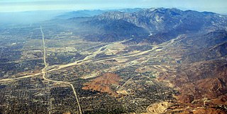
Temescal Creek is an approximately 29-mile-long (47 km) watercourse in Riverside County, in the U.S. state of California. Flowing primarily in a northwestern direction, it connects Lake Elsinore with the Santa Ana River. It drains the eastern slopes of the Santa Ana Mountains on its left and on its right the western slopes of the Temescal Mountains along its length. With a drainage basin of about 1,000 square miles (2,600 km2), it is the largest tributary of the Santa Ana River, hydrologically connecting the 720-square-mile (1,900 km2) San Jacinto River and Lake Elsinore watersheds to the rest of the Santa Ana watershed. However, flowing through an arid rain shadow zone of the Santa Ana Mountains, and with diversion of ground water for human use, the creek today is ephemeral for most of its length, except for runoff from housing developments and agricultural return flows.
Box Elder Canyon is a canyon located within the western slopes of the Wellsville Mountains, a branch of the Wasatch Range of the Rocky Mountains in Utah, United States.
Temescal Mountains, formerly the Sierra Temescal, are one of the northernmost mountain ranges of the Peninsular Ranges in western Riverside County, in Southern California in the United States. They extend for approximately 25 mi (40 km) southeast of the Santa Ana River east of the Elsinore Fault Zone to the Temecula Basin and form the western edge of the Perris Block.

Peteetneet Creek is a stream in Payson Canyon, south of Payson, Utah, United States.
Salina Creek is a tributary of the Sevier River, in Utah.

Laguña Creek also formerly also known as Tyende Creek, is a stream in the Navajo and Apache Counties of Arizona. Laguña Creek has its source at 36°41′15″N110°30′36″W, at the confluence of Long Canyon and Dowozhiebito Canyon at an elevation of 6325 feet / 1928 meters at the head of Tsegi Canyon. Its mouth is in the Chinle Valley at its confluence with Chinle Wash which together forms Chinle Creek, at an elevation of 4774 feet / 1455 meters. Chinle Creek is a tributary of San Juan River which is in turn a tributary of the Colorado River.

Chinle Creek is a tributary stream of the San Juan River in Apache County, Arizona and San Juan County, Utah. Its source is at 36°53′40″N109°44′37″W, the confluence of Laguña Creek with Chinle Wash where it forms Chinle Creek, 7 miles northeast of Dennehotso, Arizona at an elevation of 4,774 feet (1,455 m). Its mouth is at its confluence with the San Juan River at 37°11′53″N109°42′57″W at an elevation of 4,229 feet (1,289 m), 9 miles northeast of Mexican Hat, Utah.
Salt Creek is a stream in Juab County, Utah. Its mouth is at an elevation of 5,226 feet / 1,593 meters. Its source is located at 39°48′28″N111°43′43″W, the confluence of the Left Fork and Right Fork of Salt Creek in the Nebo Basin east of Mount Nebo.
Hobble Creek is a stream in Utah County, Utah. Its mouth lies at at its confluence with Utah Lake, at an elevation 4,491 feet (1,369 m). Its source is located at 40°09′45″N111°30′03″W, at the confluence of the Left Fork and Right Fork Hobble Creek in the Wasatch Range. The source lies at an elevation 5,043 feet (1,537 m).
Walker Creek is a stream in Apache County, Arizona. Its mouth is at an elevation of 4,688 feet / 1,429 meters at its confluence with Chinle Creek. Its source is located at 36°41′28″N109°15′04″W, the confluence of Alcove Canyon and Tah Chin Lini Canyon in the Carrizo Mountains, from which it flows west and northwest to Chinle Creek at 36°57′42″N109°41′35″W. Hogansaani Spring, a tributary, is located on the south side of Walker Creek, at an elevation of 5,102 feet (1,555 m), midway downstream Walker Creek to its confluence with Chinle Creek.
Bull Canyon is a canyon at the top of Palm Canyon Wash, which is a tributary to the Whitewater River, in Riverside County, California. Bull Canyon and the creek of Palm Canyon Wash heads at 33°36′47″N116°33′23″W, at an elevation of 6,165 feet in the southern western slope of a ridge in the San Jacinto Mountains. The waters of the creek of Palm Canyon Wash are augmented by Bull Canyon Spring at 33°35′22″N116°33′24″W, at an elevation of 5,331 feet / 1,625 meters. The mouth of Bull Canyon is at an elevation of 4,508 feet / 1,374 meters at the head of head of Palm Canyon. The mouth of an unnamed creek flows north down from Vandeventer Flat into the head of Palm Canyon at its confluence with Palm Canyon Wash at 33°34′08″N116°31′43″W at an elevation of 4,460 feet.
Callville Wash is an ephemeral stream or wash in Clark County, Nevada. It was named for Callville the riverport settlement founded in 1866, at its mouth where it had its original confluence with the Colorado River.
Boulder Wash is an ephemeral stream or wash in Clark County, Nevada. Its mouth is at its confluence with the Boulder Wash Cove of Lake Mead at an elevation 1,276 feet / 389 meters at when Lake Mead is at its full level. Currently as the reservoir is at a much lower level its mouth is found at approximately 36°10′07″N114°33′07″W. Its source is at 36°13′36″N114°31′22″W at an elevation of 2,841 feet / 866 meters in the Black Mountains. It flows down a canyon into the upper Pinto Valley southwestward before turning southeastward to Boulder Wash Cove.
Animas Creek is an intermittent stream in the Animas Valley within Hidalgo County, New Mexico. Is source is located at the confluence of Foster Draw and Taylor Draw, at 31°30′28″N108°52′09″W an elevation of 5,151 feet / 1,570 meters. Its mouth is in the Animas Valley, in at an elevation of 4,662 feet / 1,421 meters. However topographic maps show its wash runs farther northward to the southern outskirts of Animas, New Mexico at 31°55′51″N108°49′36″W.

Willow Creek is a major north-flowing stream in Utah, United States, and is a tributary of the Green River. The creek drains a large remote area of the East Tavaputs Plateau, flowing into the Green River south of Ouray.

Currant Creek is a stream in eastern Juab County and southern Utah County in northern Utah, United States.


