
Charleston is the capital and most populous city of the U.S. state of West Virginia and the seat of Kanawha County. It is at the confluence of the Elk and Kanawha rivers. The population was 48,864 at the 2020 census. According to 2023 census estimates, the city has a population of 46,838. The Charleston metropolitan area had 203,164 residents in 2023.

Mason County is a county in the U.S. state of West Virginia. As of the 2020 census, the population was 25,453. Its county seat and largest city is Point Pleasant. The county was founded in 1804 and named for George Mason, delegate to the U.S. Constitutional Convention. Before the Civil War, the county was in the State of Virginia.

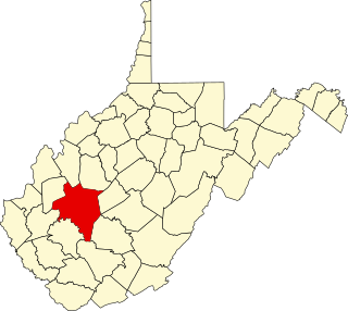
Kanawha County is a county in the U.S. state of West Virginia. As of the 2020 census, the population was 180,745, making it West Virginia's most populous county. The county seat is Charleston, which is also the state capital and most populous city. Kanawha County is part of the Charleston, WV Metropolitan Statistical Area.

The Kanawha River is a tributary of the Ohio River, approximately 97 mi (156 km) long, in the U.S. state of West Virginia. The largest inland waterway in West Virginia, its watershed has been a significant industrial region of the state since early in the 19th century.

The Little Kanawha River is a tributary of the Ohio River, 169 mi (269 km) long, in western West Virginia in the United States. Via the Ohio, it is part of the watershed of the Mississippi River, draining an area of 2,320 mi2 (6,009 km2) on the unglaciated portion of the Allegheny Plateau. It served as an important commercial water route in the early history of West Virginia, particularly in the logging and petroleum industries.

The James River and Kanawha Canal was a partially built canal in Virginia intended to facilitate shipments of passengers and freight by water between the western counties of Virginia and the coast. Ultimately its towpath became the roadbed for a rail line following the same course.

Magic Island is an island in the Kanawha River near its confluence with the Elk River in Charleston, West Virginia. Kanawha Boulevard separates Magic Island from Charleston's West Side neighborhood. It serves as a public park for the city. The island gained its name due to the rise and fall of the river level in the Kanawha, which caused the island to slip underwater, as if by "magic".
Transport in the U.S. state of West Virginia is handled by the West Virginia Department of Transportation (WVDOT) which employs more than 6,000 in West Virginia.
The Battle of Charleston was a Confederate victory in Kanawha County, Virginia, on September 13, 1862, during the American Civil War. Troops led by Major General William W. Loring defeated a Union force led by Colonel Joseph Andrew Jackson Lightburn. This battle, which featured extensive use of artillery but few casualties, was the second major fight in Loring's Kanawha Valley Campaign of 1862 that succeeded in driving Union forces out of the Kanawha River Valley. All points in the Kanawha River Valley were in the southwestern part of Virginia at the time of the battle, but are now part of the state of West Virginia.
The 9th West Virginia Infantry Regiment was an infantry regiment that served in the Union Army during the American Civil War.

The Treaty of Lochaber was signed in South Carolina on 18 October 1770 by British representative John Stuart and the Cherokee people, fixing the boundary for the western limit of the colonial frontier settlements of Virginia and North Carolina.
Kanawha Falls is an unincorporated community in Fayette County, West Virginia, United States. Kanawha Falls is located on the east bank of the Kanawha River, 2 miles (3.2 km) southwest of Gauley Bridge and 0.6 miles (0.97 km) downstream from the waterfall of the same name. Kanawha Falls had a post office, which opened on March 26, 1856, and closed on November 2, 2002.
Island Branch is an unincorporated community located in Kanawha County, West Virginia, United States.

The 1984 United States presidential election in West Virginia took place on November 6, 1984. All 50 states and the District of Columbia, were part of the 1984 United States presidential election. West Virginia voters chose 6 electors to the Electoral College, which selected the president and vice president of the United States. West Virginia was won by incumbent United States President Ronald Reagan of California, who was running against former Vice President Walter Mondale of Minnesota. Reagan ran for a second time with incumbent Vice President and former C.I.A. Director George H. W. Bush of Texas, and Mondale ran with Representative Geraldine Ferraro of New York, the first major female candidate for the vice presidency.

The West Side is a neighborhood in the city of Charleston in Kanawha County, West Virginia, United States containing about 9,900 residents.
Cooper Magisterial District is one of ten magisterial districts in Mason County, West Virginia, United States. The district was originally established as a civil township in 1863, and converted into a magisterial district in 1872. In 2020, Cooper District was home to 1,700 people.

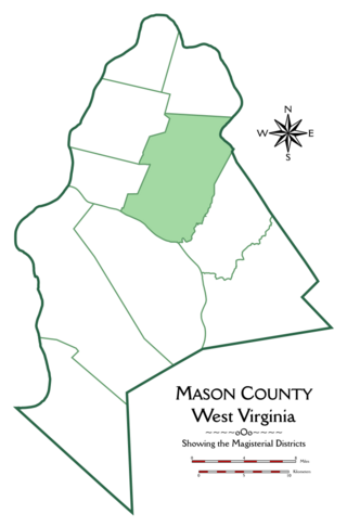
Lewis Magisterial District is one of ten magisterial districts in Mason County, West Virginia, United States. The district was originally established as a civil township in 1863, and converted into a magisterial district in 1872. In 2020, Robinson District was home to 5,635 people.

Clendenin Magisterial District is one of ten magisterial districts in Mason County, West Virginia, United States. The district was originally established as a civil township in 1863, and converted into a magisterial district in 1872. In 2020, Clendenin District was home to 3,435 people.
