The Indiana Department of Natural Resources (DNR) is the agency of the U.S. state of Indiana. There are many divisions within the DNR and each has a specific role. The DNR is not only responsible for maintaining resource areas but also manages Indiana's fish and wildlife, reclaims coal mine ground, manages forested areas, aids in the management of wildlife on private lands, enforces Indiana's conservation laws, and many other duties not named here. According to the department's website, their mission is "to protect, enhance, preserve, and wisely use natural, cultural, and recreational resources for the benefit of Indiana's citizens through professional leadership, management, and education".
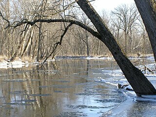
Tippecanoe River is a state park in Pulaski County, Indiana, United States. It is located 58 miles (93 km) south-southwest of South Bend, Indiana. It was formed in 1943 when the National Park Service gifted the land to Indiana's Department of Conservation land to form a state park; other land along the river becoming the Winamac Fish and Wildlife Area.
The Ray Norbut State Fish and Wildlife Area is a 1,140-acre (460 ha) state park located near Griggsville in Pike County, Illinois. It borders on the Illinois River and is primarily made of steeply sloped bluffland that is part of the river's valley. Heavily wooded, this region is managed for whitetail deer hunting. The Ray Norbut complex also includes Big Blue Island, a 100-acre (40 ha) riparian island in the Illinois River. The park is managed by the Illinois Department of Natural Resources (IDNR).
The Allegheny Wildlife Management Area is located on 6,202 acres (25.1 km2) on two separate tracts of mixed oak-hickory woodlands in western Mineral County along the Allegheny Front. The large land tract of 5,034 acres (2,037.2 ha) is accessible via Pinnacle Road and Pine Swamp Road four miles (6 km) southwest of Keyser. The smaller tract of 1,168 acres (4.7 km2) is accessed by West Virginia Route 46 and Barnum Road about 6 miles (10 km) north from Elk Garden. The Barnum Road tract consists of old farm fields along the river and the ridgetop, connected by steep slopes.

Red Hills State Park is an Illinois state park on 967 acres (391 ha) in Lawrence County, Illinois, United States. The park sits at an elevation of 515 feet (157 m). Red Hills State Park is open for year-round recreation including boating, fishing, hunting, hiking and various winter sports. The park includes a restaurant which is open year-round and has banquet facilities.

Des Plaines Fish and Wildlife Area is an Illinois state park on 5,000 acres (2,023 ha) in Will County, Illinois, United States. It is located on floodplain adjacent to the confluence of the Des Plaines River and the Kankakee River to form the Illinois River.
Marshall State Fish and Wildlife Area is an Illinois state park on 6,000 acres (2,400 ha) in Marshall County, Illinois, United States.

Silver Springs State Fish and Wildlife Area is an Illinois state park on 1,350 acres (550 ha) in Kendall County, Illinois, United States. The park was established in the late 1960s and is named for the natural spring within its boundaries. The park has two artificial lakes and the Fox River flows through the northern end of the park. Silver Springs hosts a variety of activities including fishing, hunting, boating and hiking. The park has areas of native prairie restoration, a sledding hill and a seven-mile (11 km) equestrian trail. The prairie restoration areas hold many species of plants including lead plant, and purple coneflower.
Jasper-Pulaski Fish and Wildlife Area is a hunting & fishing wildlife area administered by the Indiana Department of Natural Resource's Division of Fish & Wildlife. The Division of Fish & Wildlife is dedicated to providing a quality hunting & fishing area while maintaining 8,179 acres of wetland, upland and woodland game habitat.

Franklin Township is one of twelve townships in Pulaski County, Indiana, United States. As of the 2020 census, its population was 715 and it contained 296 housing units.
The Ohio Department of Natural Resources (ODNR) is the Ohio government agency charged with ensuring "a balance between wise use and protection of our natural resources for the benefit of all."

The Sauvie Island Wildlife Area is a state game management area on Sauvie Island in the U.S. state of Oregon. It contains more than 12,000 acres (4,856 ha) for mixed use including hunting, fishing, canoeing, kayaking, birdwatching and hiking. Established in 1974, it is located in both Multnomah and Columbia counties.

Green Bottom Wildlife Management Area is located on former plantation lands of U.S. Congressman and Confederate General Albert G. Jenkins. The 1,096 acres (444 ha) in Cabell County and Mason County are located along the banks of the Ohio River about 16 miles (26 km) north of Huntington, West Virginia. The Green Bottom WMA land is a mixture of farmland, mixed hardwood forest, wetlands, and open water. The Jenkins Plantation Museum is located on Corps of Engineers land adjacent to the WMA. The museum is located in the original 1835 Green Bottom Plantation House, and is operated by the West Virginia Division of Culture and History.

The Summer Lake Wildlife Area is a 29.6-square-mile (77 km2) wildlife refuge located on the northwestern edge of the Great Basin drainage in south-central Oregon. It is administered by the Oregon Department of Fish and Wildlife. The refuge is an important stop for waterfowl traveling along the Pacific Flyway during their spring and fall migrations. The Summer Lake Wildlife Area also provides habitat for shorebirds and other bird species as well as wide variety of mammals and several fish species. The Ana River supplies the water for the refuge wetlands.
Kingsbury Fish and Wildlife Area is a protected area that covers 7,120 acres (2,880 ha) of grasslands, wetlands, and crop fields dedicated to providing hunting and fishing opportunities. It is located south on County Road 650W, near Kingsbury, Indiana.
Tri-County Fish and Wildlife Area is a protected area that covers 3,569 acres (1,444 ha) and is dedicated to providing hunting and fishing opportunities for the public. It is located between Indiana State Road 13 and State Route 5, northeast of Warsaw, IN.
Pigeon River Fish and Wildlife Area is a protected area in northeastern Indiana that covers 12,134 acres (4,910 ha) and is dedicated to providing hunting and fishing opportunities. The area includes 529 acres (214 ha) of lakes and 17 miles (27 km) along the Pigeon River. It is located on Indiana State Road 3, near Mongo in Lagrange County. The Fish and Wildlife Area contains Tamarack Bog Nature Preserve, a 150-acre (61 ha) wetland parcel that has been designated as a National Natural Landmark.
J.E. Roush Fish and Wildlife Area is an area dedicated to providing hunting and fishing opportunities while maintaining 8,217 acres (3,325 ha), 870 acres (350 ha) of which are water of J.E. Roush Lake. It is located along U.S. Route 224 east of Huntington, Indiana. Water levels of the flood control reservoir are maintained by the U.S. Army Corps of Engineers.
Double T State Fish and Wildlife Area, also known as the Double 'T' Goose Management Area, is a 1,961 acres (794 ha) State of Illinois recreation area. It is located within Fulton County, and is administered by the Illinois Department of Natural Resources (IDNR). The nearest large town is Canton, Illinois.
