
Brown County is a county in the U.S. state of Minnesota. As of the 2020 census, the population was 25,912. Its county seat is New Ulm. The county was formed in 1855 and organized in 1856.

Lake Itasca is a small glacial lake, approximately 1.8 square miles in area. Located in southeastern Clearwater County, in the Headwaters area of north central Minnesota, it is notable for being the headwater of the Mississippi River. The lake is in Itasca State Park. It has an average depth of 20 to 35 feet and is 1,475 feet (450 m) above sea level.

The Pigeon River forms part of the Canada–United States border between the state of Minnesota and the province of Ontario, west of Lake Superior. In pre-industrial times, the river was a waterway of great importance for transportation and the fur trade.
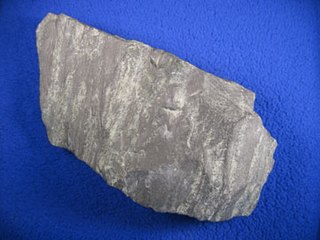
Taconite is a variety of banded iron formation, an iron-bearing sedimentary rock, in which the iron minerals are interlayered with quartz, chert, or carbonate. The name "taconyte" was coined by Horace Vaughn Winchell (1865–1923) – son of Newton Horace Winchell, the Minnesota State Geologist – during their pioneering investigations of the Precambrian Biwabik Iron Formation of northeastern Minnesota. He believed the sedimentary rock sequence hosting the iron-formation was correlative with the Taconic orogeny of New England, and referred to the unfamiliar and as-yet-unnamed iron-bearing rock as the 'taconic rock' or taconyte.

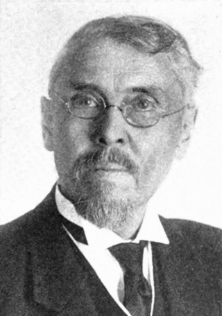
Newton Horace Winchell was an American geologist chiefly notable for his six-volume work The Geology of Minnesota: Final Report of the Geological and Natural History Survey of Minnesota, which was prepared by Winchell and his assistants. A bibliography of his publications by Warren Upham in the Bulletin of the Geological Society of America contains almost 300 titles.

Eagle Mountain is the highest natural point in Minnesota, United States, at 2,301 feet (701 m). It is in northern Cook County in the Boundary Waters Canoe Area Wilderness and Superior National Forest in the Misquah Hills, northwest of Grand Marais. It is a Minnesota State Historic Site.

The Bois de Sioux River drains Lake Traverse, the southernmost body of water in the Hudson Bay watershed of North America. It is a tributary of the Red River of the North and defines part of the western border of the U.S. state of Minnesota, and the eastern borders of North Dakota and South Dakota. It is about 41 miles (66 km) in length.

Fort Snelling State Park is a state park of the U.S. state of Minnesota, at the confluence of the Mississippi and Minnesota rivers. For many centuries, the area of the modern park has been of importance to the Mdewakanton Dakota people who consider it the center of the Earth. The state park, which opened in 1962, is named for the historic Fort Snelling, which dates from 1820. The fort structure is maintained and operated by the Minnesota Historical Society. The bulk of the state park preserves the bottomland forest, rivers, and backwater lakes below the river bluffs. Both the state and historic fort structure are part of the Mississippi National River and Recreation Area, a National Park Service site.

The Mississippi National River and Recreation Area is a 72-mile (116 km) and 54,000-acre (22,000 ha) protected corridor along the Mississippi River through the Minneapolis–Saint Paul metro in the U.S. state of Minnesota, from the cities of Dayton and Ramsey, to just downstream of Hastings. This stretch of the upper Mississippi River includes natural, historical, recreational, cultural, scenic, scientific, and economic resources of national significance. This area is the only national park site dedicated exclusively to the Mississippi River. The Mississippi National River and Recreation Area is sometimes abbreviated as MNRRA or MISS, the four letter code assigned to the area by the National Park Service. The Mississippi National River and Recreation Area is classified as one of four national rivers in the United States, and despite its name it is technically not one of the 40 national recreation areas.

The Chippewa River is a 153-mile-long (246 km) tributary of the Minnesota River in western and southwestern Minnesota in the United States. Via the Minnesota River, it is part of the watershed of the Mississippi River.

Split Rock Creek State Park is a state park of Minnesota, USA, located in Ihlen, or just south of Pipestone.
Warren Upham was an American geologist, archaeologist, and librarian who is best known for his studies of glacial Lake Agassiz.

The Misquah Hills are a range of mountains in northeastern Minnesota, in the United States. They are located in or near the Boundary Waters Canoe Area Wilderness within Superior National Forest. Eagle Mountain, the highest point in Minnesota at 2,301 feet, is considered to be part of the Misquah Hills.
Inger is an unincorporated community and census-designated place (CDP) in Itasca County, Minnesota, United States, along the Bowstring River of the Leech Lake Indian Reservation. As of the 2010 census, its population was 212.
Abita Lake is a lake in West Cook, Minnesota, which, at an elevation of 2,040.19 feet (621.85 m) above sea level, is Minnesota's ninth highest named lake. Prior to modern surveys, the lake was once believed to be Minnesota's highest elevation lake.
Ima Lake is a lake in Lake County, in the U.S. state of Minnesota.
Newton Lake is a lake in Lake County, in the U.S. state of Minnesota.

Winchell Trail is a five-mile (8 km) round trip, pedestrian-only trail in Minneapolis, Minnesota, United States, that runs along the west side of the Mississippi River between Franklin Avenue South and East 44th Street. Popular with bird watchers and naturalists, the rustic trail provides Upper Mississippi River gorge access and views. The trail is separate from the adjacent multi-use bicycle path, taking hikers past sandy beaches, an oak savanna restoration project, and the floodplain forest. The trail has multiple access points and the section from East 38th Street to East 44th Street is paved. Described as moderate and for all hiking skill levels, the out-and-back Winchell Trail has total elevation gain of 501 feet (153 m). Portions of the trail can be hiked in near solitude as its age and general destitute make it a widely forgotten place to explore.
