Brule Lake (Minnesota)

Last updated

Brule Lake
USA Minnesota relief location map.svg
Red pog.svg
Brule Lake
Location Cook County, Minnesota, U.S.
Coordinates 47°56′25″N90°40′56″W / 47.94028°N 90.68222°W / 47.94028; -90.68222 Coordinates: 47°56′25″N90°40′56″W / 47.94028°N 90.68222°W / 47.94028; -90.68222
Primary outflows Temperance River, Brule River
Basin  countriesUnited States
Surface area4,272 acres (17 km2)
Max. depth78 ft (24 m)
Surface elevation1,851 ft (564 m)

Brule Lake is a lake in Cook County, Minnesota. It is situated between two long sills in the Superior Upland, causing the lake to be eight times longer east and west than it is north and south. Out of the opposite ends flow the Temperance River and the South Brule, a tributary of the Brule River. Brule Lake was logged heavily in the early 1900s, and the region around it was consumed in 1929 by a logging-related forest fire which bears Brule Lake's name. Now the lake is part of the protected Boundary Waters Canoe Area, a federal wilderness area for which Brule Lake serves as an entrance point.

Contents

Topography

Brule Lake is one of the largest lakes in the eastern Arrowhead Region of Minnesota. [1] It has an area of 4272 acres, and a maximum depth of 78 feet. [2] It sits 1851 feet above sea level. [3] It measures approximately eight miles from east to west, and one mile from north to south. [4] Brule Lake is located in the Duluth Complex, a geological region marked by bands of softer, more erodible bedrock, and "red rock," a harder and less easily eroded stone, which forms protruding ridges across the Superior Uplands. [5] In the region of the Brule, these ridges run nearly exactly east-west, and long, thin lakes lie between them. [5] The valley in which Brule Lake is located is bound on the north by the Misquah Hills, and on the south by another sill peaked by Brule Mountain. Though the distance between these points is only four miles, the valley is six hundred feet deep. [6] Brule Mountain, Misquah Hill (Point 2230), and Eagle Mountain are all prominent red rock monadnocks surrounding Brule Lake. [7] Misquah Hill was erroneously identified as the highest point in Minnesota during the 1890s, until the United States Department of the Interior resurveyed in 1961, concluding that Eagle Mountain was taller by 74 feet. [8]

Brule Lake is the source of both the Temperance and the South Brule Rivers. [4] The Temperance drains from the west side of the lake, and flows some thirty miles until entering Lake Superior near Tofte. The South Brule drains from the east and flows some forty miles until entering Lake Superior forty three miles northeast of the mouth of the Temperance. [4] The Temperance and Brule have the fourth and third largest catchment areas of any stream entering Lake Superior in Minnesota. [9] Separated from the mainland by these two watersheds are the Poplar, Cascade, and Devil Track rivers, which drain a total of slightly over 300 square miles of land themselves. [9]

Plant and animal life

Brule Lake was stocked for walleye prior to 1985, and presently supports a self-sustained population. [2] Smaller walleye's major forage, yellow perch, are small in number in Brule. This limits the size of the walleye population, although once they grow large enough they can forage on Brule's much larger cisco population. [2] Northern pike and smallmouth bass are also sport fish found in this lake. The 2009 survey also turned up white sucker. [2]

In February 1926, the Minnesota Game and Fish department organized a survey of the Brule and Winchell lakes region, which reported a heavy presence of moose, a comparatively light presence of deer, also timber wolves, foxes, mink, and the trail of a Canadian lynx. [10]

Human use

Brule Lake lies in a region which has seen human population since the end of the last ice age. [11] It has variously been within the territory of the Dakota, Cree, Ojibwa, French, British, and Americans. [12] It saw little development until the opening of a railroad that allowed loggers easier access to the interior of the Arrowhead region's dense pine forest. A survey of the region was made by Ulysses S. Grant II and Newton Horace Winchell in 1893, which established the surface elevation of the Brule and the heights of many of the hills around it. [13] In 1898, the Duluth and Northern Minnesota Railroad was opened to service the logging firm of Alger, Smith Company, and in time a spur of this railroad was built to Lake Brule. [14]

Around 1920, the General Logging Company had acquired the rights to stands of white pine in the region of Brule Lake from the Alger, Smith Company. [15] Laws requiring the removal of pine slash were not being effectively enforced in the region, increasing the danger of forest fire. [16] On July 22, 1929, a fire was spotted between Brule and Star Lake. [16] Twenty one days later, [16] the Brule Lake Fire had burned 25,708 acres of forest, cost $20,000 to extinguish, and demonstrated the insufficiency of the United States Forest Service's firefighting capacity in the region. [17]

With the decline of the lumber industry between 1920 and 1940, many lumber railways were dismantled, including the Alger line. [18] The railroad grade was acquired by the county [19] and now functions as a gravel road, known as "The Grade," which provides the only access for motorized vehicles to Brule Lake.

In 1925, an unauthorized 112-foot-long (34 m) canal was blasted between Brule Lake and the South Brule River, while a dam was built to close off its outlet into the Temperance. [20] These were later repaired, using nearby boulders, brush, and two bags of cement. [21] [22] During the 1920s, Edward Wellington Backus was attempting to build hydroelectric dams on northern Minnesotan rivers, [23] and the blasting was likely connected to this development. It has been variously blamed on land speculators trying to convince buyers that the Brule had enough flow to be a viable source of hydroelectric power, [22] or upon employees of a local development company working towards the same purpose. [20]

Brule Lake and much of the land around it gradually was brought under federal protection, and came to be incorporated into what is now the Boundary Waters Canoe Area. [24] In 1964, the United States government passed the Wilderness Act, designating the BWCA a wilderness area under special conservation rules. [24] Lakes such as Brule where motorboats had previously been used were given temporary variances for continued motor use. [25] As a resort was located on Brule's shores, motorboats with a motor under 10 horsepower were permitted by law to continue to operate until 1994 or the resort closed. Since the resort closed, Brule Lake is open only to non-motorized craft. [26]

See also

Related Research Articles

<span class="mw-page-title-main">St. Croix River (Wisconsin–Minnesota)</span> River in Wisconsin and Minnesota, United States

The St. Croix River is a tributary of the Mississippi River, approximately 169 miles (272 km) long, in the U.S. states of Wisconsin and Minnesota. The lower 125 miles (201 km) of the river form the border between Wisconsin and Minnesota. The river is a National Scenic Riverway under the protection of the National Park Service. A hydroelectric plant at the Saint Croix Falls Dam supplies power to the Minneapolis–St. Paul metropolitan area.

<span class="mw-page-title-main">Boundary Waters Canoe Area Wilderness</span> Wilderness area in Minnesota, United States

The Boundary Waters Canoe Area Wilderness is a 1,090,000-acre (4,400 km2) wilderness area within the Superior National Forest in the northeastern part of the US state of Minnesota under the administration of the U.S. Forest Service. A mixture of forests, glacial lakes, and streams, the BWCAW's preservation as a primitive wilderness began in the 1900s and culminated in the Boundary Waters Canoe Area Wilderness Act of 1978. It is a popular destination for canoeing, hiking, and fishing, and is one of the most visited wildernesses in the United States.

<span class="mw-page-title-main">County State-Aid Highway 12 (Cook County, Minnesota)</span> Highway in Minnesota

County State-Aid Highway 12 (CSAH 12), also known as the Gunflint Trail, or County Road 12 (CR 12), is a 57-mile (92 km) paved roadway and National Scenic Byway in Cook County, Minnesota, that begins in Grand Marais and ends at Saganaga Lake in the Boundary Waters Canoe Area Wilderness (BWCAW), near the U.S. border with Ontario. It provides access to many of the entry points in the BWCAW.

<span class="mw-page-title-main">Eagle Mountain (Minnesota)</span>

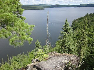
Eagle Mountain is the highest natural point in Minnesota, United States, at 2,301 feet (701 m). It is in northern Cook County in the Boundary Waters Canoe Area Wilderness and Superior National Forest in the Misquah Hills, northwest of Grand Marais. It is a Minnesota State Historic Site.

<span class="mw-page-title-main">Lake Vermilion</span> Lake in the state of Minnesota, United States

Lake Vermilion is a shallow freshwater lake in northeastern Minnesota, United States. The Ojibwe originally called the lake Onamanii-zaaga'iganiing, which means “the evening sun tinting the water a reddish color”. French fur traders translated this to the Latin word Vermilion, which is a red pigment. Lake Vermilion is located between the towns of Tower on the east and Cook on the west, in the heart of Minnesota's Arrowhead Region at Vermilion Iron Range. The area was mined from the late 19th century until the 1960s, and the Soudan Mine operated just south of the lake.

<span class="mw-page-title-main">Arrowhead Region</span>

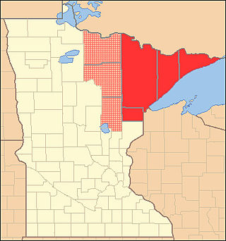
The Arrowhead Region is located in the northeastern part of the U.S. state of Minnesota, so called because of its pointed shape. The predominantly rural region encompasses 10,635.26 square miles (27,545.2 km2) of land area and includes Carlton, Cook, Lake and Saint Louis counties. Its population at the 2000 census was 248,425 residents. The region is loosely defined, and Aitkin, Itasca, and Koochiching counties are sometimes considered as part of the region, increasing the land area to 18,221.97 square miles (47,194.7 km2) and the population to 322,073 residents. Primary industries in the region include tourism and iron mining.

<span class="mw-page-title-main">Superior National Forest</span> National forest in Minnesota, United States

Superior National Forest, part of the United States National Forest system, is located in the Arrowhead Region of the state of Minnesota between the Canada–United States border and the north shore of Lake Superior. The area is part of the greater Boundary Waters region along the border of Minnesota and the Canadian province of Ontario, a historic and important thoroughfare in the fur trading and exploring days of New France and British North America.

<span class="mw-page-title-main">Judge C. R. Magney State Park</span> State park in Minnesota, United States

Judge C. R. Magney State Park is a state park in the U.S. state of Minnesota, on the North Shore of Lake Superior. It was named for Clarence R. Magney, a former mayor of Duluth and justice of the Minnesota Supreme Court, who was instrumental in getting 11 state parks and scenic waysides established along the North Shore. The park is best known for the Devil's Kettle, an unusual waterfall and rock formation in which half of the Brule River disappears into a pothole.

<span class="mw-page-title-main">Geography of Minnesota</span> Overview of the geography of Minnesota

The U.S. State of Minnesota is the northernmost state outside Alaska; its isolated Northwest Angle in Lake of the Woods is the only part of the 48 contiguous states lying north of the 49th parallel north. Minnesota is in the U.S. region known as the Upper Midwest in interior North America. The state shares a Lake Superior water border with Michigan and Wisconsin on the northeast; the remainder of the eastern border is with Wisconsin. Iowa is to the south, South Dakota and North Dakota are to the west, and the Canadian provinces of Manitoba and Ontario are to the north. With 87,014 square miles (225,370 km2), or approximately 2.26% of the United States, Minnesota is the 12th largest state.

<span class="mw-page-title-main">Misquah Hills</span>

The Misquah Hills are a range of mountains in northeastern Minnesota, in the United States. They are located in or near the Boundary Waters Canoe Area Wilderness within Superior National Forest. Eagle Mountain, the highest point in Minnesota at 2,301 feet, is considered to be part of the Misquah Hills.

<span class="mw-page-title-main">Whale Lake</span> Lake in the state of Minnesota, United States

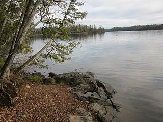
Whale Lake is a lake in Cook County in what is known as the Arrowhead Region of northern Minnesota. It is within the Boundary Waters Canoe Area Wilderness of the Superior National Forest, at the base of Eagle Mountain, Minnesota's highest point. Two miles (3 km) from the nearest road, Whale Lake is only accessible via the Eagle Mountain Hiking Trail from the south, or the Brule Lake Trail from the northwest. It offers two campsites to hikers, one on the northern shore near the intersection of the two trails, and the other a few hundred yards away from the western shore.

<span class="mw-page-title-main">Natural history of Minnesota</span>

The natural history of Minnesota covers many plant and animal species in the U.S. state of Minnesota. The continental climate and location of Minnesota at the physiographic intersection of the Laurentian and the Interior Plains influences its plant and animal life. Three of North America's biomes converge in Minnesota: prairie grasslands in the southwestern and western parts of the state, the eastern temperate deciduous forests in the east-central and the southeast, and the coniferous forest in the north-central and northeast.

<span class="mw-page-title-main">Poplar River (Lake Superior)</span> River in Minnesota, United States

The Poplar River is a river in northeastern Minnesota that drains into Lake Superior.

<span class="mw-page-title-main">Temperance River</span> River in Minnesota, United States

The Temperance River is a 39.2-mile-long (63.1 km) river in northern Minnesota. It drains into Lake Superior along its north shore just south of Tofte. It flows out of Brule Lake in Cook County generally south towards its mouth within Temperance River State Park. Its name is supposedly a pun on its lack of a sand bar.

Abita Lake is a lake in West Cook, Minnesota, which, at an elevation of 2,040.19 feet (621.85 m) above sea level, is Minnesota's ninth highest named lake. Prior to modern surveys, the lake was once believed to be Minnesota's highest elevation lake.

<span class="mw-page-title-main">Boundary Waters Canoe Area Wilderness Act</span>

The BWCA Wilderness Act of 1978 created the Boundary Waters Canoe Area Wilderness, which was previously known as the Boundary Waters Canoe Area. The bill was introduced in October 1975 by United States Congressman Jim Oberstar and was a source of major controversy and debate. Topics of major concern were logging, mining, the use of snowmobiles and motorboats. After much debate, the Act was signed into law by President Jimmy Carter on October 21, 1978.

<span class="mw-page-title-main">Crescent Lake (Minnesota)</span> Lake in the state of Minnesota, United States

Crescent Lake is a lake located in Tofte Township and Lutsen Township, Cook County, Minnesota.

<span class="mw-page-title-main">Gooseberry River</span> River in Minnesota, United States

Gooseberry River is a 23-mile stream in Lake County, Minnesota, USA, draining into Lake Superior. It is known for its waterfalls, near its mouth in Gooseberry Falls State Park. The Gooseberry, like many of its neighboring streams, has an irregular discharge highly dependent on runoff from rain and snow melt. The region around the river was heavily forested and much logging took place during the early 20th century. The forest has since regrown and the falls and mouth of the river are now a thriving tourist destination.

<span class="mw-page-title-main">Rose Lake (Pigeon River)</span> Lake in the state of Minnesota, United States

Rose Lake is a lake on the border between Cook County, Minnesota and Ontario.

Smoke Lake is a lake in Cook County, Minnesota within Tofte Township. It is within the Boundary Waters Canoe Area Wilderness and the Superior National Forest. The lake can be accessed by a 100 rods (500 m) portage from Sawbill Lake to the west and a 90 rods (450 m) portage from Burnt Lake to the east, which in turn is accessed from Entry Point 39 at Baker Lake through Peterson and Kelly lakes.

References

  1. Minnesota Game and Fish Department. Fins, Feathers and Fur. vol. 29–54. p.43 Sept. 1925.
  2. 1 2 3 4 Brule Lake information report, Minnesota Department of Natural Resources, 2009. Retrieved May 23, 2012.
  3. Minnesota State Drainage Commission. Report of the Water Resources Investigation of Minnesota, 1911–1912. p.569. McGill-Warner, 1912.
  4. 1 2 3 Grant, U.S., "Lakes With Two Outlets in Northern Minnesota", p. 408. The American Geologist, Volume 19, 1897.
  5. 1 2 Steeg, Karl ver. "The Influence of Geologic Structure on the Drainage Pattern in Northeastern Minnesota." The Journal of Geology, p. 353. Vol. 55, No. 4 (Jul. 1947)
  6. Berkey, Chas P. "Preliminary Report of the Levelling Party." Annual Report, for the Year 1881. Ed. Winchell, N. H. Geological and Natural History Survey of Minnesota. p. 136. St. Paul, 1882.
  7. Steeg, Karl ver. "The Influence of Geologic Structure on the Drainage Pattern in Northeastern Minnesota." The Journal of Geology, Vol. 55, No. 4 (Jul. 1947), p. 355.
  8. Summit plaque, Eagle Mountain, Minnesota Historical Society, 1967
  9. 1 2 Eberhart, Adolph Olson; Ralph, Georg A.; Follansbee, Robert. Report of the Water Resources Investigation of Minnesota, 1911–1912. p. 521.
  10. Brule Lake Trek Appeals to Many. p. 68. Fins, Feathers, and Fur, Official Bulletin of the Minnesota Game and Fish Department. No 44, March 1926.
  11. Gibbon, Guy E.; Johnson, Craig M.; Hobbes, Elizabeth (2000). "Chapter 3: Minnesota's Environment and Native American Culture History". A Predictive Model of Precontact Archaeological Site Location for The State of Minnesota. Minnesota Department of Transportation. Archived from the original on July 26, 2011. Retrieved December 25, 2011.
  12. Wilbers, Steven. Boundary Waters Chronology Accessed May 21, 2012.
  13. Berkey, Chas P. "Preliminary Report of the Levelling Party." Annual Report, for the Year 1881. Ed. Winchell, N. H. Geological and Natural History Survey of Minnesota. p. 134. St. Paul, 1882.
  14. Wolff, Julius F. "Some Vanished Settlements of the Arrowhead Country." Minnesota History. v. 34, p. 181.
  15. Wolff, Julius F. "Some Major Forest Fires in the Sawbill Country." Minnesota History, Vol. 36, No. 4 (Dec. 1958). p. 132.
  16. 1 2 3 Wolff, Julius F. "Some Major Forest Fires in the Sawbill Country." Minnesota History, Vol. 36, No. 4 (Dec. 1958). p. 133.
  17. Wolff, Julius F. "Some Major Forest Fires in the Sawbill Country." Minnesota History, Vol. 36, No. 4 (Dec. 1958). p. 134.
  18. Ryan, J. C. "Minnesota Logging Railroads" Minnesota History. Vol. 24, Issue 4 (1946) p. 301.
  19. State of Minnesota Department of Natural Resources. All-Terrain Vehicle Use On the North Shore State Trail: A Feasibility Study. March 1, 2006. p. 37.
  20. 1 2 "Northern Lakes Present Varied Problems". p. 43. Fins, Feathers, and Fur, Official Bulletin of the Minnesota Game and Fish Department. No 43, September 1925.
  21. Brule Lake Trek Appeals to Many. p. 67. Fins, Feathers, and Fur, Official Bulletin of the Minnesota Game and Fish Department. No 44, March 1926.
  22. 1 2 Brickner, Joe. Completing the Game and Fish House. Cook County New Herald, December 22, 1960.
  23. Chronology of the BWCA, Minnesota Humanities, Archived March 26, 2012, at the Wayback Machine , Retrieved July 20, 2010.
  24. 1 2 BWCA History, accessed May 21, 2012.
  25. US Forest Service. Forest Roadless Area Inventory and Evaluation. p. C-2
  26. Title 36: Parks, Forests, and Public Property, 293.16 Special provisions governing the Boundary Waters Canoe Area Wilderness, Superior National Forest, Minnesota. Archived June 20, 2010, at the Wayback Machine