Related Research Articles

In meteorology, a cyclone is a large air mass that rotates around a strong center of low atmospheric pressure, counterclockwise in the Northern Hemisphere and clockwise in the Southern Hemisphere as viewed from above. Cyclones are characterized by inward-spiraling winds that rotate about a zone of low pressure. The largest low-pressure systems are polar vortices and extratropical cyclones of the largest scale. Warm-core cyclones such as tropical cyclones and subtropical cyclones also lie within the synoptic scale. Mesocyclones, tornadoes, and dust devils lie within the smaller mesoscale.

An anticyclone is a weather phenomenon defined as a large-scale circulation of winds around a central region of high atmospheric pressure, clockwise in the Northern Hemisphere and counterclockwise in the Southern Hemisphere as viewed from above. Effects of surface-based anticyclones include clearing skies as well as cooler, drier air. Fog can also form overnight within a region of higher pressure.

Physical oceanography is the study of physical conditions and physical processes within the ocean, especially the motions and physical properties of ocean waters.
Rossby waves, also known as planetary waves, are a type of inertial wave naturally occurring in rotating fluids. They were first identified by Sweden-born American meteorologist Carl-Gustaf Arvid Rossby in the Earth's atmosphere in 1939. They are observed in the atmospheres and oceans of Earth and other planets, owing to the rotation of Earth or of the planet involved. Atmospheric Rossby waves on Earth are giant meanders in high-altitude winds that have a major influence on weather. These waves are associated with pressure systems and the jet stream. Oceanic Rossby waves move along the thermocline: the boundary between the warm upper layer and the cold deeper part of the ocean.

In meteorology, a low-pressure area, low area or low is a region where the atmospheric pressure is lower than that of surrounding locations. Low-pressure areas are commonly associated with inclement weather, while high-pressure areas are associated with lighter winds and clear skies. Winds circle anti-clockwise around lows in the northern hemisphere, and clockwise in the southern hemisphere, due to opposing Coriolis forces. Low-pressure systems form under areas of wind divergence that occur in the upper levels of the atmosphere (aloft). The formation process of a low-pressure area is known as cyclogenesis. In meteorology, atmospheric divergence aloft occurs in two kinds of places:

The Pacific decadal oscillation (PDO) is a robust, recurring pattern of ocean-atmosphere climate variability centered over the mid-latitude Pacific basin. The PDO is detected as warm or cool surface waters in the Pacific Ocean, north of 20°N. Over the past century, the amplitude of this climate pattern has varied irregularly at interannual-to-interdecadal time scales. There is evidence of reversals in the prevailing polarity of the oscillation occurring around 1925, 1947, and 1977; the last two reversals corresponded with dramatic shifts in salmon production regimes in the North Pacific Ocean. This climate pattern also affects coastal sea and continental surface air temperatures from Alaska to California.
This is a list of meteorology topics. The terms relate to meteorology, the interdisciplinary scientific study of the atmosphere that focuses on weather processes and forecasting.

A mesoscale convective system (MCS) is a complex of thunderstorms that becomes organized on a scale larger than the individual thunderstorms but smaller than extratropical cyclones, and normally persists for several hours or more. A mesoscale convective system's overall cloud and precipitation pattern may be round or linear in shape, and include weather systems such as tropical cyclones, squall lines, lake-effect snow events, polar lows, and mesoscale convective complexes (MCCs), and generally forms near weather fronts. The type that forms during the warm season over land has been noted across North and South America, Europe, and Asia, with a maximum in activity noted during the late afternoon and evening hours.

Sea spray consists of aerosol particles formed from the ocean, primarily by ejection into Earth's atmosphere through bursting bubbles at the air-sea interface Sea spray contains both organic matter and inorganic salts that form sea salt aerosol (SSA). SSA has the ability to form cloud condensation nuclei (CCN) and remove anthropogenic aerosol pollutants from the atmosphere. Coarse sea spray has also been found to inhibit the development of lightning in storm clouds.
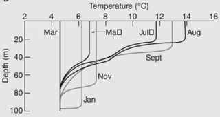
The oceanic or limnological mixed layer is a layer in which active turbulence has homogenized some range of depths. The surface mixed layer is a layer where this turbulence is generated by winds, surface heat fluxes, or processes such as evaporation or sea ice formation which result in an increase in salinity. The atmospheric mixed layer is a zone having nearly constant potential temperature and specific humidity with height. The depth of the atmospheric mixed layer is known as the mixing height. Turbulence typically plays a role in the formation of fluid mixed layers.
The Hadley cell, also known as the Hadley circulation, is a global-scale tropical atmospheric circulation that features air rising near the equator, flowing poleward near the tropopause at a height of 12–15 km (7.5–9.3 mi) above the Earth's surface, cooling and descending in the subtropics at around 25 degrees latitude, and then returning equatorward near the surface. It is a thermally direct circulation within the troposphere that emerges due to differences in insolation and heating between the tropics and the subtropics. On a yearly average, the circulation is characterized by a circulation cell on each side of the equator. The Southern Hemisphere Hadley cell is slightly stronger on average than its northern counterpart, extending slightly beyond the equator into the Northern Hemisphere. During the summer and winter months, the Hadley circulation is dominated by a single, cross-equatorial cell with air rising in the summer hemisphere and sinking in the winter hemisphere. Analogous circulations may occur in extraterrestrial atmospheres, such as on Venus and Mars.

Tropical cyclogenesis is the development and strengthening of a tropical cyclone in the atmosphere. The mechanisms through which tropical cyclogenesis occur are distinctly different from those through which temperate cyclogenesis occurs. Tropical cyclogenesis involves the development of a warm-core cyclone, due to significant convection in a favorable atmospheric environment.

Extratropical cyclones, sometimes called mid-latitude cyclones or wave cyclones, are low-pressure areas which, along with the anticyclones of high-pressure areas, drive the weather over much of the Earth. Extratropical cyclones are capable of producing anything from cloudiness and mild showers to severe gales, thunderstorms, blizzards, and tornadoes. These types of cyclones are defined as large scale (synoptic) low pressure weather systems that occur in the middle latitudes of the Earth. In contrast with tropical cyclones, extratropical cyclones produce rapid changes in temperature and dew point along broad lines, called weather fronts, about the center of the cyclone.

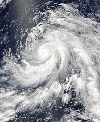
A tropical cyclone is a rapidly rotating storm system with a low-pressure center, a closed low-level atmospheric circulation, strong winds, and a spiral arrangement of thunderstorms that produce heavy rain and squalls. Depending on its location and strength, a tropical cyclone is called a hurricane, typhoon, tropical storm, cyclonic storm, tropical depression, or simply cyclone. A hurricane is a strong tropical cyclone that occurs in the Atlantic Ocean or northeastern Pacific Ocean. A typhoon occurs in the northwestern Pacific Ocean. In the Indian Ocean and South Pacific, comparable storms are referred to as "tropical cyclones". In modern times, on average around 80 to 90 named tropical cyclones form each year around the world, over half of which develop hurricane-force winds of 65 kn or more.

In meteorology, eyewall replacement cycles, also called concentric eyewall cycles, naturally occur in intense tropical cyclones with maximum sustained winds greater than 33 m/s, or hurricane-force, and particularly in major hurricanes of Saffir–Simpson category 3 to 5. In such storms, some of the outer rainbands may strengthen and organize into a ring of thunderstorms—a new, outer eyewall—that slowly moves inward and robs the original, inner eyewall of its needed moisture and angular momentum. Since the strongest winds are in a tropical cyclone's eyewall, the storm usually weakens during this phase, as the inner wall is "choked" by the outer wall. Eventually the outer eyewall replaces the inner one completely, and the storm may re-intensify.
The Tropical Atlantic SST Dipole refers to a cross-equatorial sea surface temperature (SST) pattern that appears dominant on decadal timescales. It has a period of about 12 years, with the SST anomalies manifesting their most pronounced features around 10–15 degrees of latitude off of the Equator. It is also referred to as the interhemispheric SST gradient or the Meridional Atlantic mode.

This glossary of meteorology is a list of terms and concepts relevant to meteorology and atmospheric science, their sub-disciplines, and related fields.
Cyclonic Niño is a climatological phenomenon that has been observed in climate models where tropical cyclone activity is increased. Increased tropical cyclone activity mixes ocean waters, introducing cooling in the upper layer of the ocean that quickly dissipates and warming in deeper layers that lasts considerably more, resulting in a net warming of the ocean.
Open ocean convection is a process in which the mesoscale ocean circulation and large, strong winds mix layers of water at different depths. Fresher water lying over the saltier or warmer over the colder leads to the stratification of water, or its separation into layers. Strong winds cause evaporation, so the ocean surface cools, weakening the stratification. As a result, the surface waters are overturned and sink while the "warmer" waters rise to the surface, starting the process of convection. This process has a crucial role in the formation of both bottom and intermediate water and in the large-scale thermohaline circulation, which largely determines global climate. It is also an important phenomena that controls the intensity of the Atlantic Meridional Overturning Circulation (AMOC).
Ocean dynamical thermostat is a physical mechanism through which changes in the mean radiative forcing influence the gradients of sea surface temperatures in the Pacific Ocean and the strength of the Walker circulation. Increased radiative forcing (warming) is more effective in the western Pacific than in the eastern where the upwelling of cold water masses damps the temperature change. This increases the east-west temperature gradient and strengthens the Walker circulation. Decreased radiative forcing (cooling) has the opposite effect.
References
- ↑ "Wind-induced surface heat exchange". AMS Glossary. Retrieved 7 March 2010.
- ↑ Craig, George C.; Gray, Suzanne L. (1 December 1996). "CISK or WISHE as the Mechanism for Tropical Cyclone Intensification". Journal of the Atmospheric Sciences. 53 (23): 3528–3540. Bibcode:1996JAtS...53.3528C. doi: 10.1175/1520-0469(1996)053<3528:COWATM>2.0.CO;2 .
| | This meteorology–related article is a stub. You can help Wikipedia by expanding it. |
| | This article about or related to tropical cyclones is a stub. You can help Wikipedia by expanding it. |