Related Research Articles
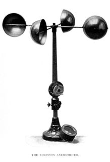
An anemometer is a device used for measuring wind speed and direction. It is also a common weather station instrument. The term is derived from the Greek word anemos, which means wind, and is used to describe any wind speed instrument used in meteorology. The first known description of an anemometer was given by Leon Battista Alberti in 1450.
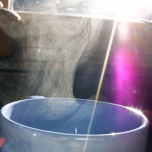
Evaporation is a type of vaporization that occurs on the surface of a liquid as it changes into the gas phase. The surrounding gas must not be saturated with the evaporating substance. When the molecules of the liquid collide, they transfer energy to each other based on how they collide with each other. When a molecule near the surface absorbs enough energy to overcome the vapor pressure, it will escape and enter the surrounding air as a gas. When evaporation occurs, the energy removed from the vaporized liquid will reduce the temperature of the liquid, resulting in evaporative cooling.

A pitottube, also known as pitot probe, is a flow measurement device used to measure fluid flow velocity. The pitot tube was invented by the French engineer Henri Pitot in the early 18th century and was modified to its modern form in the mid-19th century by French scientist Henry Darcy. It is widely used to determine the airspeed of an aircraft, water speed of a boat, and to measure liquid, air and gas flow velocities in certain industrial applications.

Wind speed, or wind flow speed, is a fundamental atmospheric quantity caused by air moving from high to low pressure, usually due to changes in temperature. Note that wind direction is usually almost parallel to isobars, due to Earth's rotation.

A weather station is a facility, either on land or sea, with instruments and equipment for measuring atmospheric conditions to provide information for weather forecasts and to study the weather and climate. The measurements taken include temperature, atmospheric pressure, humidity, wind speed, wind direction, and precipitation amounts. Wind measurements are taken with as few other obstructions as possible, while temperature and humidity measurements are kept free from direct solar radiation, or insolation. Manual observations are taken at least once daily, while automated measurements are taken at least once an hour. Weather conditions out at sea are taken by ships and buoys, which measure slightly different meteorological quantities such as sea surface temperature (SST), wave height, and wave period. Drifting weather buoys outnumber their moored versions by a significant amount.

Apparent wind is the wind experienced by a moving object.

Physical oceanography is the study of physical conditions and physical processes within the ocean, especially the motions and physical properties of ocean waters.

In fluid dynamics, wind waves, or wind-generated waves, are water surface waves that occur on the free surface of bodies of water. They result from the wind blowing over an area of fluid surface. Waves in the oceans can travel thousands of miles before reaching land. Wind waves on Earth range in size from small ripples, to waves over 100 ft (30 m) high.

A cooling tower is a heat rejection device that rejects waste heat to the atmosphere through the cooling of a water stream to a lower temperature. Cooling towers may either use the evaporation of water to remove process heat and cool the working fluid to near the wet-bulb air temperature or, in the case of closed circuit dry cooling towers, rely solely on air to cool the working fluid to near the dry-bulb air temperature.
This is a list of meteorology topics. The terms relate to meteorology, the interdisciplinary scientific study of the atmosphere that focuses on weather processes and forecasting.

An observation tower is a structure used to view events from a long distance and to create a full 360 degree range of vision to conduct the long distance observations. They are usually at least 20 metres (66 ft) tall and made from stone, iron, and wood. Many modern towers are also used as TV towers, restaurants, or churches. The towers first appeared in the ancient world, as long ago as the Babylonian Empire.

A swell, in the context of an ocean, sea or lake, is a series of mechanical waves that propagate along the interface between water and air and thus are often referred to as surface gravity waves. These series of surface gravity waves are not wind waves, which are generated by the immediate local wind, but instead are generated by distant weather systems, where wind blows for a duration of time over a fetch of water. More generally, a swell consists of wind-generated waves that are not—or are hardly—affected by the local wind at that time. Swell waves often have a long wavelength, but this varies due to the size, strength and duration of the weather system responsible for the swell and the size of the water body. Swell wavelength also varies from event to event. Occasionally, swells which are longer than 700 m occur as a result of the most severe storms. Swells have a narrower range of frequencies and directions than locally generated wind waves, because swell waves have dispersed from their generation area, have dissipated and therefore lost an amount of randomness, taking on a more defined shape and direction. Swell direction is the direction from which the swell is coming. It is measured in degrees, and often referred to in general directions, such as a NNW or SW swell.

Wet chemistry is a form of analytical chemistry that uses classical methods such as observation to analyze materials. It is called wet chemistry since most analyzing is done in the liquid phase. Wet chemistry is also called bench chemistry since many tests are performed at lab benches.
FLUXNET is a global network of micrometeorological tower sites that use eddy covariance methods to measure the exchanges of carbon dioxide, water vapor, and energy between the biosphere and atmosphere. FLUXNET is a global 'network of regional networks' that serves to provide an infrastructure to compile, archive and distribute data for the scientific community. It works to ensure that different flux networks are calibrated to facilitate comparison between sites, and it provides a forum for the distribution of knowledge and data between scientists.

Meteorological instruments are the equipment used to sample the state of the atmosphere at a given time. Each science has its own unique sets of laboratory equipment. Meteorology, however, is a science which does not use much lab equipment but relies more on on-site observation and remote sensing equipment. In science, an observation, or observable, is an abstract idea that can be measured and for which data can be taken. Rain was one of the first quantities to be measured historically. Two other accurately measured weather-related variables are wind and humidity. Many attempts had been made prior to the 15th century to construct adequate equipment to measure atmospheric variables.
Surface weather observations are the fundamental data used for safety as well as climatological reasons to forecast weather and issue warnings worldwide. They can be taken manually, by a weather observer, by computer through the use of automated weather stations, or in a hybrid scheme using weather observers to augment the otherwise automated weather station. The ICAO defines the International Standard Atmosphere (ISA), which is the model of the standard variation of pressure, temperature, density, and viscosity with altitude in the Earth's atmosphere, and is used to reduce a station pressure to sea level pressure. Airport observations can be transmitted worldwide through the use of the METAR observing code. Personal weather stations taking automated observations can transmit their data to the United States mesonet through the Citizen Weather Observer Program (CWOP), the UK Met Office through their Weather Observations Website (WOW), or internationally through the Weather Underground Internet site. A thirty-year average of a location's weather observations is traditionally used to determine the station's climate. In the US a network of Cooperative Observers make a daily record of summary weather and sometimes water level information.
Droughts are a relatively common feature of the weather in the United Kingdom, with one around every 5–10 years on average. These droughts are usually during the summer, when a blocking high causes hot, dry weather for an extended period. However droughts can vary in their characteristics. All types of drought cause issues across all sectors, with impacts extending to the ecosystem, agriculture and the economy of the whole country in severe cases of drought. The south east of the country usually suffers most, as it has the highest population and the lowest average precipitation per year, which is even lower in a drought. Even in these areas in severe droughts, the definition, impacts, effects and management are all minimal in comparison to drought prone areas such as Australia and parts of the United States. In recent years however, the summers of 2007, 2008, 2009, August 2010 and 2012 were wetter than normal, 2007 being wettest on record.
Wind Powering America (WPA) is an initiative of the United States Department of Energy (DOE) that seeks to increase the use of wind energy throughout the United States. WPA collaborates with key state and regional stakeholders, including farmers, ranchers, Native Americans, rural electric cooperatives, consumer-owned utilities, and schools to break down barriers associated with wind energy development.
Global terrestrial stilling is the decrease of wind speed observed near the Earth's surface over the last three decades, originally termed "stilling". This slowdown of near-surface terrestrial winds has mainly affected mid-latitude regions of both hemispheres, with a global average reduction of −0.140 m s−1 dec−1 or between 5 and 15% over the past 50 years. With high-latitude showing increases in both hemispheres. In contrast to the observed weakening of winds over continental surfaces, winds have tended to strengthen over ocean regions. In the last few years, a break in this terrestrial decrease of wind speed has been detected suggesting a recovery at global scales since 2013.

This glossary of meteorology is a list of terms and concepts relevant to meteorology and atmospheric science, their sub-disciplines, and related fields.