Related Research Articles
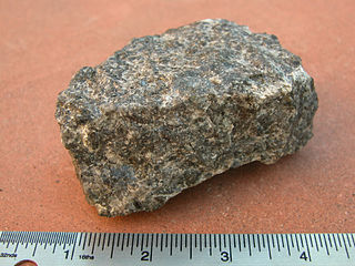
Gabbro is a phaneritic (coarse-grained), mafic intrusive igneous rock formed from the slow cooling of magnesium-rich and iron-rich magma into a holocrystalline mass deep beneath the Earth's surface. Slow-cooling, coarse-grained gabbro is chemically equivalent to rapid-cooling, fine-grained basalt. Much of the Earth's oceanic crust is made of gabbro, formed at mid-ocean ridges. Gabbro is also found as plutons associated with continental volcanism. Due to its variant nature, the term gabbro may be applied loosely to a wide range of intrusive rocks, many of which are merely "gabbroic". By rough analogy, gabbro is to basalt as granite is to rhyolite.

Dunite, also known as olivinite, is an intrusive igneous rock of ultramafic composition and with phaneritic (coarse-grained) texture. The mineral assemblage is greater than 90% olivine, with minor amounts of other minerals such as pyroxene, chromite, magnetite, and pyrope. Dunite is the olivine-rich endmember of the peridotite group of mantle-derived rocks.
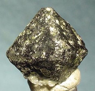
Chromite is a crystalline mineral composed primarily of iron(II) oxide and chromium(III) oxide compounds. It can be represented by the chemical formula of FeCr2O4. It is an oxide mineral belonging to the spinel group. The element magnesium can substitute for iron in variable amounts as it forms a solid solution with magnesiochromite (MgCr2O4). A substitution of the element aluminium can also occur, leading to hercynite (FeAl2O4). Chromite today is mined particularly to make stainless steel through the production of ferrochrome (FeCr), which is an iron-chromium alloy.

Pyroxenite is an ultramafic igneous rock consisting essentially of minerals of the pyroxene group, such as augite, diopside, hypersthene, bronzite or enstatite. Pyroxenites are classified into clinopyroxenites, orthopyroxenites, and the websterites which contain both types of pyroxenes. Closely allied to this group are the hornblendites, consisting essentially of hornblende and other amphiboles.

Ultramafic rocks are igneous and meta-igneous rocks with a very low silica content, generally >18% MgO, high FeO, low potassium, and are composed of usually greater than 90% mafic minerals. The Earth's mantle is composed of ultramafic rocks. Ultrabasic is a more inclusive term that includes igneous rocks with low silica content that may not be extremely enriched in Fe and Mg, such as carbonatites and ultrapotassic igneous rocks.
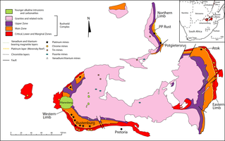
The Bushveld Igneous Complex (BIC) is the largest layered igneous intrusion within the Earth's crust. It has been tilted and eroded forming the outcrops around what appears to be the edge of a great geological basin: the Transvaal Basin. It is approximately 2 billion years old and is divided into four different limbs: the northern, southern, eastern, and western limbs. The Bushveld Complex comprises the Rustenburg Layered suite, the Lebowa Granites and the Rooiberg Felsics, that are overlain by the Karoo sediments. The site was first publicised around 1897 by Gustaaf Molengraaff who found the native South African tribes residing in and around the area.

The Great Dyke or Dike is a linear geological feature that trends nearly north-south through the centre of Zimbabwe passing just to the west of the capital, Harare. It consists of a band of short, narrow ridges and hills spanning for approximately 550 kilometres (340 mi). The hills become taller as the range goes north, and reach up to 460 metres (1,510 ft) above the Mvurwi Range. The range is host to vast ore deposits, including gold, silver, chromium, platinum, nickel and asbestos.

The Narryer Gneiss Terrane is a geological complex in Western Australia that is composed of a tectonically interleaved and polydeformed mixture of granite, mafic intrusions and metasedimentary rocks in excess of 3.3 billion years old, with the majority of the Narryer Gneiss Terrane in excess of 3.6 billion years old. The rocks have experienced multiple metamorphic events at amphibolite or granulite conditions, resulting in often complete destruction of original igneous or sedimentary (protolith) textures. Importantly, it contains the oldest known samples of the Earth's crust: samples of zircon from the Jack Hills portion of the Narryer Gneiss have been radiometrically dated at 4.4 billion years old, although the majority of zircon crystals are about 3.6-3.8 billion years old.

A layered intrusion is a large sill-like body of igneous rock which exhibits vertical layering or differences in composition and texture. These intrusions can be many kilometres in area covering from around 100 km2 (39 sq mi) to over 50,000 km2 (19,000 sq mi) and several hundred metres to over one kilometre (3,300 ft) in thickness. While most layered intrusions are Archean to Proterozoic in age, they may be any age such as the Cenozoic Skaergaard intrusion of east Greenland or the Rum layered intrusion in Scotland. Although most are ultramafic to mafic in composition, the Ilimaussaq intrusive complex of Greenland is an alkalic intrusion.

Cumulate rocks are igneous rocks formed by the accumulation of crystals from a magma either by settling or floating. Cumulate rocks are named according to their texture; cumulate texture is diagnostic of the conditions of formation of this group of igneous rocks. Cumulates can be deposited on top of other older cumulates of different composition and colour, typically giving the cumulate rock a layered or banded appearance.

The Yilgarn Craton is a large craton that constitutes a major part of the Western Australian land mass. It is bounded by a mixture of sedimentary basins and Proterozoic fold and thrust belts. Zircon grains in the Jack Hills, Narryer Terrane have been dated at ~4.27 Ga, with one detrital zircon dated as old as 4.4 Ga.
The geology of Australia includes virtually all known rock types, spanning a geological time period of over 3.8 billion years, including some of the oldest rocks on earth. Australia is a continent situated on the Indo-Australian Plate.
The Gawler Craton covers approximately 440,000 square kilometres of central South Australia. Its Precambrian crystalline basement crustal block was cratonised ca. 1550–1450 Ma. Prior to 1550 Ma the craton comprised a number of active Proterozoic orogenic belts extending back in time to at least 2450 Ma.
The Emily Ann and Maggie Hays nickel deposits are situated 117 km west of the town of Norseman, Western Australia, within the Lake Johnston Greenstone Belt.

Harzburgite, an ultramafic, igneous rock, is a variety of peridotite consisting mostly of the two minerals olivine and low-calcium (Ca) pyroxene (enstatite); it is named for occurrences in the Harz Mountains of Germany. It commonly contains a few percent chromium-rich spinel as an accessory mineral. Garnet-bearing harzburgite is much less common, found most commonly as xenoliths in kimberlite.

Chromitite is an igneous cumulate rock composed mostly of the mineral chromite. It is found in layered intrusions such as the Bushveld Igneous Complex in South Africa, the Stillwater igneous complex in Montana and the Ring of Fire discovery in Ontario.
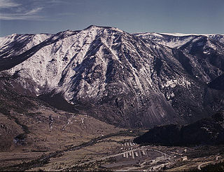
The Stillwater igneous complex is a large layered mafic intrusion (LMI) located in southern Montana in Stillwater, Sweet Grass and Park Counties. The complex is exposed across 30 miles (48 km) of the north flank of the Beartooth Mountain Range. The complex has extensive reserves of chromium ore and has a history of being mined for chromium. More recent mining activity has produced palladium and other platinum group elements.
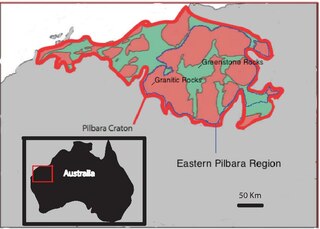
The Eastern Pilbara Craton is the eastern portion of the Pilbara Craton located in Western Australia. This region contains variably metamorphosed mafic and ultramafic greenstone belt rocks, intrusive granitic dome structures, and volcanic sedimentary rocks. These greenstone belts worldwide are thought to be the remnants of ancient volcanic belts, and are subject to much debate in today's scientific community. Areas such as Isua and Barberton which have similar lithologies and ages as Pilbara have been argued to be subduction accretion arcs, while others suggest that they are the result of vertical tectonics. This debate is crucial to investigating when/how plate tectonics began on Earth. The Pilbara Craton along with the Kaapvaal Craton are the only remaining areas of the Earth with pristine 3.6–2.5 Ga crust. The extremely old and rare nature of this crustal region makes it a valuable resource in the understanding of the evolution of the Archean Earth.

The Southern Oklahoma Aulacogen is a failed rift, or failed rift arm (aulacogen), of the triple junction that became the Iapetus Ocean spreading ridges. It is a significant geological feature in the Western and Southern United States. It formed sometime in the early to mid Cambrian Period and spans the Wichita Mountains, Taovayan Valley, Anadarko Basin, and Hardeman Basin in Southwestern Oklahoma. The Southern Oklahoma Aulacogen is primarily composed of basaltic dikes, gabbros, and units of granitic rock.

The geology of the Kimberley, a region of Western Australia, is a rock record of the early Proterozoic eon that includes tectonic plate collision, mountain-building (orogeny) and the joining (suturing) of the Kimberley and Northern Australia cratons, followed by sedimentary basin formation.
References
- ↑ Ivanic, Tim; Wingate, Kirkland; Van Kranendonk, Wyche (2010). "Age and significance of voluminous mafic–ultramafic magmatic events in the Murchison Domain, Yilgarn Craton". Australian Journal of Earth Sciences. 57 (5): 597–614. Bibcode:2010AuJES..57..597I. doi: 10.1080/08120099.2010.494765 . S2CID 129922696.
- ↑ Van Kranendonk, Martin; Ivanic (2009). Geological Survey of Western Australia Annual Review.
{{cite journal}}: Missing or empty|title=(help) - ↑ Ahmat, Tony (1986). Petrology, structure, regional geology and age of the gabbroic Windimurra complex, Western Australia. unpublised PhD thesis, University of Western Australia.
- ↑ "Joint venture to develop vanadium processing project at Windimurra welcomed". WA State Government. Western Australia. 4 November 1997.
- ↑ Xstrata PLC (10 May 2004). "Closure of the Windimurra operation". Switzerland. Archived from the original (Press Release) on 7 March 2011.