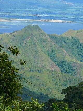
The Cordillera de la Costa montane forests is a montane ecoregion of the tropical and subtropical moist broadleaf forests biome, in the Venezuelan Coastal Range on the Caribbean Sea in northern Venezuela.
The Caribbean bioregion is a biogeographic region that includes the islands of the Caribbean Sea and nearby Atlantic islands, which share a fauna, flora and mycobiota distinct from surrounding bioregions.

The Motagua Valley thornscrub ecoregion is located in the Motagua valley in eastern Guatemala. Surrounded by mountains and receiving relatively little precipitation, the valley is one of the driest in Central America and is characterized by thorn scrub vegetation. It covers an area of 2330 km2 and belongs to the deserts and xeric shrublands biome, as defined by the World Wildlife Fund.

The Belizean pine forests is an ecoregion that represents an example of lowland and premontane pine forests in the Neotropical realm, where the dominant tree species is Caribbean pine. The vegetation here is generally adapted to the xeric, acidic and nutrient-poor conditions along the Belizean near coastal zone of the Caribbean versant.

The Hainan Island monsoon rain forests ecoregion covers mountainous interior of Hainan Island in China. The tropical forests receive over 1,000 mm/year of rain, heavily concentrated in the summer rainy season. The island has high levels of biodiversity, with over 4,200 plant species, 630 of which are endemic to the island. The region is under ecological pressure from deforestation for agriculture and timber extraction.
The Eastern Java-Bali rain forests ecoregion covers the lowland areas of the eastern half of the island of Java, and the island of Bali, in Indonesia. This ecoregion is distinct from the Eastern Java-Bali montane rain forests, which exists at higher elevations where mountain forest habitat dominates. Very little of the natural lowland rainforest remains in its pre-human settlement state.

The Western Java rain forests ecoregion covers the lowland rain forests below 1,000 meters in elevation in the western half of the island of Java in Indonesia. There are a variety of forest types - evergreen, semi-evergreen, moist deciduous, and even some patches of freshwater swamp. The forests have degraded by conversion of the low areas to agriculture, and by logging. National parks protect some of the last remaining untouched rain forest. A number of endangered mammals are found in the ecoregion, including the Javan rhinoceros, the silvery gibbon, and the Javan surili.

The Baluchistan xeric woodlands ecoregion covers the middle elevations of a series of mountain ranges of western Pakistan and northeastern Afghanistan, reaching 1,200 kilometres (750 mi) from the Arabian Sea in the south to the Hindu Kush Mountains and the Himalayas in the north. The characteristic vegetation is xeric (dry) woodlands of shrubs and herbaceous cover. The region has rich biodiversity but relatively few endemic species.

The Sulaiman Range alpine meadows ecoregion covers a series of higher altitude mountain ranges along the crest of the Sulaiman Mountains, a southerly extension of the Hindu Kush Mountains along the Afghanistan-Pakistan border. The area is relatively undeveloped, with about a third of the terrain either forested or in 'alpine steppe' shrub or herbaceous cover.

The Coastal Venezuelan mangroves ecoregion covers the salt-water mangrove forests along the Caribbean Sea and Atlantic Ocean coast of Venezuela, from Cocinetas Basin to the edge of the Caño Manamo River and the Orinoco Delta in the east. It is one of the largest mangrove ecoregions in South America, with an area of 5,698 km2, and stretching across over 400 km of Venezuelan coastline.
The Magdalena-Santa Marta mangroves ecoregion covers the mangrove forests along the coast of Colombia on the Caribbean Sea, from Gulf of Urabá in the west at the Colombia-Panama border to the Guajira Peninsula in the east. The region is relatively dry, with low precipitation and high evapotranspiration, so the mangroves depend for water and nutrients on the rivers flowing across the estuarine plain from the Sierra Nevada de Santa Marta mountains to the east. Efforts are currently underway to restore mangroves degraded by development and road building from the 1950s to 1980s.

The Petenes mangroves ecoregion covers mangrove habitat along the Gulf of Mexico coast of southern Mexico, where Campeche state and Yucatan state meet, centering on the Celestun Lagoon inland from the barrier-island town of Celestún. Because the region has relatively little rainfall and no rivers feeding the lagoons, the freshwater to support the mangrove ecosystem springs from underground aquifers. The area is important for migratory birds, and as a nesting area for sea turtles. The area around the Celestun Lagoon is protected by the Ría Celestún Biosphere Reserve, a UNESCO Biosphere Reserve, and Los Petenes Biosphere Reserve in Campeche.

The Usumacinta mangroves ecoregion covers the mangrove forests ont the Gulf Coast of Mexico, around the margins of the Laguna de Términos. The "Ends" in the name refer to the mouths of the rivers that empty into the lagoon, including the Usumacinta River. This region, which is due south of the mouth of the Mississippi River across the Gulf of Mexico, receives an estimated one-third of the wintering birds migrating on the Mississippi Flyway. It is estimated that the lagoon supports 90 endangered species.

The Leeward Islands moist forests ecoregion covers the forested areas of the Leeward Islands on the northeastern edge of the Caribbean Sea, stretching from the Virgin Islands in the west to Guadeloupe to the southeast. The forested areas are typically in the core interior of the islands, and at the higher elevations of the volcanic islands. Non-forested lower elevations in the region receive less rainfall and are typically semi-arid. A notable feature of the ecoregion is its position in the main hurricane track. The frequent damage to trees produces in many places an uneven forest canopy, and an opening of the canopy that allows more pre-climax trees to grow.
The Leeward Islands xeric scrub ecoregion covers the dry ('xeric'), non-forested areas of the Leeward Islands on the northeastern edge of the Caribbean Sea, stretching from the Virgin Islands in the west to Guadeloupe to the southeast. The non-forested areas are generally low scrub shrub, on the low elevations around the peripheries of the islands. Non-forested lower elevations in the region receive less rainfall and are typically semi-arid. A notable feature of the ecoregion is its position in the main hurricane track. The frequent damage to trees allows more pre-climax shrubs and trees to grow. There are a number of endemic species, as in common with islands.

The Trinidad and Tobago moist forests ecoregion covers most of Trinidad Island and Tobago Island near the coast of South America where the southeastern Caribbean Sea meets the Atlantic Ocean. Small portions of the islands around river estuaries and coastal lowlands are mangroves or dry forests. Species diversity is very high, in particular for plants and birds. Tobago, being much smaller, has fewer species.

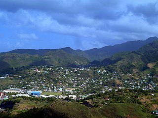
The Windward Islands moist forests ecoregion covers forested, high-precipitation areas of the volcanic Windward Islands. The forested areas are mostly at higher elevations in the interior of the islands, surrounded by dry forests, dry shrubland, or mangroves on the flat coastal lowlands. Closed forest of this ecoregion cover the majority of the islands. Species diversity is very high.
The Cayman Islands xeric scrub ecoregion covers a portion of the Cayman Islands in the Caribbean Sea. The dry ('xeric') parts of the island are surrounded by mangroves, dry forest, or developed areas. Grand Cayman Island has been heavily cleared or degraded for human development; while the less populated islands have more intact shrub and wooded habitat.
The Lesser Antillean dry forests ecoregion covers the dry forests of the coastal lowlands of the Lesser Antilles, where the eastern Caribbean Sea meets the Atlantic Ocean. These forests generally form a band around the interior wet forests of higher elevations, and because they are often flat, they are under the most pressure for human settlement and agriculture.

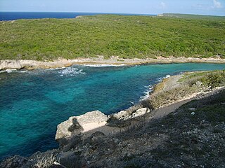
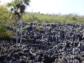
The Aruba-Curaçao-Bonaire cactus scrub ecoregion covers the dry land on the semi-arid islands of Aruba, Curaçao, and Bonaire in the southern Caribbean Sea, about 80 km from the mainland of Venezuela. In low-lying coastal areas the islands also support mangrove wetlands. The landscape features a range of cactus species and acacia trees.

