
Burnham is a large village and civil parish that lies north of the River Thames in Buckinghamshire, between the towns of Maidenhead and Slough, about 24 miles west of Charing Cross, London. It is probably best known for the nearby Burnham Beeches woodland.
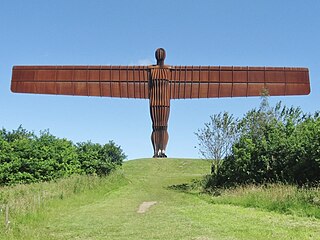
The Metropolitan Borough of Gateshead is a metropolitan borough in the metropolitan county of Tyne and Wear, England. It includes Gateshead, Rowlands Gill, Whickham, Blaydon, Ryton, Felling, Birtley, Pelaw, Dunston and Low Fell. The borough forms part of the Tyneside conurbation, centred on Newcastle upon Tyne. At the 2021 census, the borough had a population of 196,154.

Higham is a village in the Borough of Pendle in Lancashire, England, south of Pendle Hill. The civil parish is named Higham with West Close Booth. The village is 2 miles (3 km) north-east of Padiham and about 4 miles (6 km) south-west of Nelson along the A6068 road.

West Lulworth is a village and civil parish in the English county of Dorset, situated on the English Channel beside Lulworth Cove. In the 2011 census the civil parish—which includes most of Lulworth Camp army base—had 291 households and a population of 714. The village is a gateway to the Jurassic Coast World Heritage Site and is a popular tourist destination, especially for day trips.

Blaydon is a town in the Metropolitan Borough of Gateshead, Tyne and Wear, England, and historically in County Durham. Blaydon, and neighbouring Winlaton, which Blaydon is now contiguous with, form the town of Blaydon-on-Tyne. The Blaydon/Winlaton ward had a population in 2011 of 13,896.

Blaydon was a constituency represented in the House of Commons from 2017 until its abolition for the 2024 general election by Liz Twist of the Labour Party.

Henbury is a suburb of Bristol, England, approximately 5 miles (8.0 km) north west of the city centre. It was formerly a village in Gloucestershire and is now bordered by Westbury-on-Trym to the south; Brentry to the east and the Blaise Castle Estate, Blaise Hamlet and Lawrence Weston to the west. To the north lie the South Gloucestershire village of Hallen and the entertainment/retail park Cribbs Causeway.

Low Westwood is a village in County Durham, England. It is situated immediately to the west of Hamsterley. Low Westwood is probably best known for Hamsterley Christ Church and Derwent care home.
Rudgeway is a village in South Gloucestershire in south west England, located between Alveston and Almondsbury on the A38 trunk road. It lies west of Earthcott, Latteridge, Iron Acton and Yate on the B4059 road.

Rowlands Gill is a village on the north bank of the River Derwent, in the Metropolitan Borough of Gateshead, Tyne and Wear, England. The Gibside Estate is near the town.
Ryton is a village in Tyne and Wear, England. It is in the Metropolitan Borough of Gateshead, historically part of County Durham. In 2011, the population of the Ryton, Crookhill and Stella ward was 8,146. It is 6 miles (9.7 km) west of Newcastle upon Tyne.

Crawcrook is a village in the Metropolitan Borough of Gateshead in Tyne and Wear, England. The population taken at the 2021 Census of the Gateshead ward was 9,058, increasing from 8,841 in 2011. The village is historically part of County Durham.
High Spen is an old mining village in the Metropolitan Borough of Gateshead, historically part of County Durham, England. First recorded in 1379 as a small hamlet called ‘Spen’, the settlement grew in the latter half of the 19th and early 20th centuries with the growth of coal mining in the region. In a modern post-industrial North East England, High Spen functions as a commuter village in the Tyneside greenbelt with 1,935 people calling the village home

Cleadon is a suburban village in South Tyneside in the North East of England. Prior to the creation of Tyne and Wear in 1974 by the Local Government Act 1972, the village was part of the historic County Durham. In the 2011 UK Census the population of the South Tyneside ward of Cleadon and East Boldon was 8,427. Nearby population centres include East Boldon, Whitburn, and Jarrow. The village is located approximately 5 miles (8 km) from the city of Sunderland and 5 miles from the town South Shields. It is situated on the south west of Cleadon Hills, an example of a Magnesian Limestone grassland home to a number of regionally and nationally rare species.

Stella is a community in the Metropolitan Borough of Gateshead, Tyne and Wear, England. It lies on the south bank of the Tyne, about 5 miles (8 km) west of central Newcastle upon Tyne, between Blaydon and Ryton. The area includes the Stella Park housing estate, built on the grounds of a mansion of the same name.

Winlaton is a village situated in the Metropolitan Borough of Gateshead, Tyne and Wear, England. Historically in County Durham, it was incorporated into the metropolitan county of Tyne and Wear and Borough of Gateshead in 1974. In 2011 the village was absorbed into the Gateshead MBC ward of Winlaton and High Spen. The population of this ward at the 2011 census was 8,342.

Thorp Academy is a large 11–18 secondary Academy in Ryton Tyne & Wear, England. The academy was established in the 19th century by Charles Thorp who went on to found Durham University. The site that Thorp Academy now stands on is the site of the original school established by Charles Thorp. In the early 2010's, Gateshead Council merged Ryton Comprehensive School and Hookergate School in High Spen. With the two schools merging, the school was renamed Charles Thorp Comprehensive School. The school later converted into an academy sponsored by Northern Education Trust and was renamed as Thorp Academy.
Derwenthaugh Coke Works was a coking plant on the River Derwent near Swalwell in Gateshead. The works were built in 1928 on the site of the Crowley's Iron Works, which had at one time been the largest iron works in Europe. The coke works was closed and demolished in the late 1980s, and replaced by Derwenthaugh Park.

Haugh or The Haugh is a small village or hamlet in East Ayrshire, Parish of Mauchline, Scotland. The habitation is situated about two and a half miles downstream from Catrine, on the north bank of the River Ayr. The River Ayr Way runs through the village.

Blaydon and Consett is a constituency of the House of Commons in the UK Parliament. Created as a result of the 2023 Periodic Review of Westminster constituencies, it was first contested at the 2024 general election and is currently held by Liz Twist of the Labour Party, who previously represented the abolished Blaydon constituency from 2017 to 2024.

