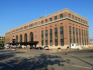
Union Station, also known as New Haven Railroad Station or simply New Haven, is the main railroad passenger station in New Haven, Connecticut. Designed by noted American architect Cass Gilbert, the beaux-arts Union Station was completed and opened in 1920 after the previous Union Station was destroyed by fire. It served the New York, New Haven and Hartford Railroad until it fell into decline, along with the rest of the railroad industry in North America after World War II. It was shuttered in 1972, leaving only the under-track 'subway' open for passengers, and listed on the National Register of Historic Places on September 3, 1975, but it was almost demolished before the Northeast Corridor Improvement Project in 1979. Reopened after extensive renovations in early 1985, it is now the premier gateway to the city.

Westville is a neighborhood of the city of New Haven, Connecticut. It is consistently ranked as one of the best neighborhoods to live in New Haven due to its high home values, low crime rates, walkable streets, proximity to downtown, and local amenities.
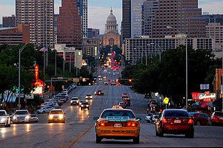
Congress Avenue is a major thoroughfare in Austin, Texas. The street is a six-lane, tree lined avenue that cuts through the middle of the city from far south Austin and goes over Lady Bird Lake leading to the Texas State Capitol in the heart of Downtown.

The Munger Place Historic District is a neighborhood and historic district in Old East Dallas, Texas (USA), generally lying between North Fitzhugh Avenue on the southwest, Gaston Avenue on the northwest, Henderson Avenue on the northeast, and Columbia Avenue on the southeast. Detailed boundaries are defined in the Munger Place Ordinance. It is a Dallas Landmark District and listed on the National Register of Historic Places.
The Downtown Winter Haven Historic District is a U.S. historic district located in Winter Haven, Florida. The district is bounded by roughly Avenue A Northwest, Avenue A Southwest, 3rd and 5th Streets. It contains 26 historic buildings.

The Pope Avenue Historic District is a U.S. historic district located in Winter Haven, Florida. The district is bounded roughly by Avenue A Northwest, Pope Avenue Northwest, 6th and 7th Streets Northwest. It contains 29 historic buildings.
The Tampa Heights Historic District is a U.S. historic district in Tampa, Florida. It is bounded by Adalee Street, I-275, 7th Avenue and North Tampa Avenue, encompasses approximately 200 acres (0.81 km2), and contains 289 historic buildings. On August 4, 1995, it was added to the U.S. National Register of Historic Places. The district includes Lee Elementary School of Technology World Studies, the first brick school in Hillsborough County, Florida.

The boundary markers of the original District of Columbia are the 40 milestones that marked the four lines forming the boundaries between the states of Maryland and Virginia and the square of 100 square miles (259 km²) of federal territory that became the District of Columbia in 1801. Working under the supervision of three commissioners that President George Washington had appointed in 1790 in accordance with the federal Residence Act, a surveying team that Major Andrew Ellicott led placed these markers in 1791 and 1792. Among Ellicott's assistants were his brothers Joseph and Benjamin Ellicott, Isaac Roberdeau, George Fenwick, Isaac Briggs and an African American astronomer, Benjamin Banneker.

The Rochelle Park–Rochelle Heights Historic District is a historic residential district located in the city of New Rochelle in Westchester, New York. The district is historically and architecturally significant as an intact and distinctive example of residential park development at the turn of the Twentieth Century. It includes the historic Rochelle Park development, and the later Rochelle Heights subdivision. Within the district are 555 contributing properties, including 513 buildings, 38 structures, and 4 sites. Only 24 buildings and 1 site separately identified within its area are non-contributing. It was listed on the National Register of Historic Places (NRHP) on July 6, 2005.

The following outline is provided as an overview of and topical guide to District of Columbia:

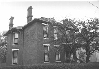
The Dwight Street Historic District is an irregularly shaped 135-acre (55 ha) historic district in New Haven, Connecticut. The district is located immediately west of the center of Downtown New Haven and is generally bounded by Elm Street on the north, Park Street on the east, North Frontage Road on the south, and Sherman Avenue on the west. It contains one of the city's highest concentrations of well-preserved 19th and early 20th-century residential architecture, much of which was developed for the working classes in the city's factories. It was listed on the National Register of Historic Places in 1983. The historic district includes most of the Dwight neighborhood and several blocks of the northeast corner of the West River neighborhood.
The city of New Haven, Connecticut has many distinct neighborhoods. In addition to Downtown, centered on the central business district and the Green, are the following neighborhoods: the west central neighborhoods of Dixwell and Dwight; the southern neighborhoods of The Hill, historic water-front City Point, and the harborside district of Long Wharf; the western neighborhoods of Edgewood, West River, Westville, Amity, and West Rock; East Rock, Cedar Hill, Prospect Hill, and Newhallville in the northern side of town; the east central neighborhoods of Mill River and Wooster Square, an Italian-American neighborhood; Fair Haven, an immigrant community located between the Mill and Quinnipiac rivers; Quinnipiac Meadows and Fair Haven Heights across the Quinnipiac River; and facing the eastern side of the harbor, The Annex and East Shore.

The Water Street District, a large part of downtown Lock Haven in the U.S. state of Pennsylvania, is an historic district added to the National Register of Historic Places (NRHP) in 1973. The district includes the city's entire central business district as well as many homes and churches constructed in the 19th century, especially during the Victorian era. An inventory of the district in 1973 listed more than 365 historic resources, many of which were associated with wealth created by the lumber industry.

The Orange Street Historic District encompasses a large residential in the East Rock section of New Haven, Connecticut. Roughly bounded by Orange, Cottage, Eagle, State, and Audubon Streets, this area saw growth between about 1830 and 1900, and includes a broad diversity of well-preserved 19th-century residential structures. It was listed on the U.S. National Register of Historic Places in 1985. At that time, it included 546 buildings deemed to contribute to the historic character of the area.

Quinnipiac River Historic District is a 313-acre (127 ha) historic district straddling the Quinnipiac River in the Fair Haven and Fair Haven Heights neighborhoods of New Haven, Connecticut. It encompasses most of the historic maritime village of Fair Haven, with a history dating back to the 18th century. It was listed on the National Register of Historic Places in 1984. At that time it included 524 contributing buildings, an inland wetland at the mouth of Hemingway Creek on the northeast corner of the district, and the Grand Avenue Swing Bridge over the Quinnipiac River connecting Fair Haven with Fair Haven Heights at the center of the district.

Forest Park is a Victorian garden district located in Springfield, Massachusetts, developed between 1880 and 1920. It is the city's most populous neighborhood, and surrounds the 735-acre Frederick Law Olmsted–designed Forest Park, for which the neighborhood is named. The Forest Park neighborhood has nature and recreation within walking distance. To the west, I-91 separates Forest Park from the Connecticut River. A 195-acre section of the neighborhood was listed on the National Register of Historic Places in 1982 as the Forest Park Heights Historic District.

The 27th Street Historic District is a historic district in the South Los Angeles area of Los Angeles, California. The district was listed on the National Register of Historic Places in 2009 as part of the multiple property submission for African Americans in Los Angeles.
Woodward Heights is a neighborhood and historic district located immediately west of downtown Lexington, Kentucky. It is bounded by Maxwell Street and the Pleasant Green Hill neighborhood to the southwest, by the parking lot for Rupp Arena to the southeast, by the Lexington Convention Center property to the northeast, and by Herlihy, Cox, and High Streets to the north.

The West Line Historic District is a residential community in central Austin, Texas, United States. The district encompasses an approximately 90-block tract of land located west of downtown. Bounded by Baylor Street to the east, Fifth Street to the south, Thirteenth Street to the north and Texas State Highway Loop 1 to the west. It is located south of the Old West Austin Historic District and southeast of the Clarksville Historic District.


