Related Research Articles
The Wiradjuri people are a group of Aboriginal Australian people who were united by a common language, strong ties of kinship and survived as skilled hunter–fisher–gatherers in family groups or clans scattered throughout central New South Wales.

The Wingecarribee River, a perennial river that is part of the Hawkesbury–Nepean catchment, is located in the Southern Highlands region of New South Wales, Australia.

Leeton is a town located in the Riverina region of southern New South Wales, Australia. Situated approximately 550 km west of Sydney and 450 km north of Melbourne in the Murrumbidgee Irrigation Area, it is the administrative centre of the Leeton Shire Council local government area. Leeton's urban population in 2016 was 8,623. Situated in one of the most productive farming regions in the state, the town was designed by Walter Burley Griffin and purpose-built for the irrigation schemes announced by the New South Wales government in the early 1900s. Citrus, rice, cotton, grapes, walnuts and wheat farms can all be found throughout the Leeton Shire. Leeton is renowned as Australia's Rice Capital and as The Heart of SunRice Country, as it is home to the SunRice headquarters. Other industry includes Freedom Foods, the Daily Drinks Co., JBS Australia, Webster Limited and Murrumbidgee Irrigation Limited.

Yanco is a village with a population of 505 in Leeton Shire in south western New South Wales, Australia. Yanco is a Wiradjuri aboriginal language word meaning the sound of running water. Yanco is located 3 kilometres (1.9 mi) from Leeton along Irrigation Way. Yanco is home to the Powerhouse Museum, McCaughey Park, Murrumbidgee Rural Studies Centre and Yanco Agricultural High School.

Leeton Shire is a local government area in the Riverina region of New South Wales, Australia. The Shire is located adjacent to the Murrumbidgee River and falls within the Murrumbidgee Irrigation Area.
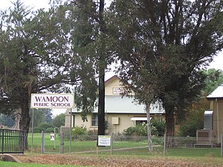
Wamoon is a village in Leeton Shire in the Riverina region of New South Wales, Australia. Wamoon is located 8.8 kilometres (5.5 mi) from Leeton along the Irrigation Way to the Leeton CBD and Henry Lawson Drive to the Leeton suburb of Wattle Hill. Wamoon provides a village of homes to the farmers of northern Leeton and there is a small primary school known as Wamoon Public School.

The Murrumbidgee Irrigation Area (MIA) is geographically located within the Riverina area of New South Wales. It was created to control and divert the flow of local river and creek systems for the purpose of food production. The main river systems feeding and fed by the area are the Murrumbidgee and the Tumut. It is one of the most diverse and productive regions in Australia contributing over A$5 billion annually to the Australian economy.
Wattle Hill is a north-western suburb of Leeton, New South Wales. Wattle Hill was developed in the 1970s and 80's as a joint venture between Leeton Shire Council and the New South Wales Department of Housing. Wattle Hill has a large concentration of housing department homes particularly on Gossamer, Wirilda and Blackwood Streets. The rest of the suburb has private residences, a small shopping precinct and three parks, one of which has a large water tower that supplies water to Wattle Hill and Wamoon. During the development of Wattle Hill, it was proposed that a state primary school was to be built in the suburb with land set aside to the west of the suburb, however, the school was built in the nearby suburb of Parkview. Prior to redevelopment, Wattle Hill was an unofficial low-income housing area for many local families. There were many homes there without floors, constructed from poles, flattened 4-gallon drums and hessian.
Parkview is a residential suburb of Leeton, New South Wales in Leeton Shire. Parkview is located to the south west of town, and can be accessed via the Oak Street Bridge. Parkview is home to Leeton's second state school, Parkview Public School, a small shop and butcher, two churches, and an array of sporting facilities such as tennis and basketball courts. Leeton's showground, racecourse and the MIA Sports Club are located to the east of the suburb across the railway track.

Gralee is a suburb of Leeton, New South Wales in Leeton Shire. Gralee facilities include:

Willimbong is a suburb of Leeton, New South Wales, Australia in Leeton Shire. Willimbong has a mix of industrial and residential properties. Leeton's SunRice and Coprice Mills are located in Willimbong as well as the Berri Juice Factory, MIA Rural Services, Cummins and the Country Energy Field Service Centre. Willimbong is also home to a large park known as Waipukurau Park, a corner store and Leeton Pre-School and Leeton Day Care Centre. Residential Streets in Willimbong include, Russet Street, Seville Street, Valencia Street and Elberta Street.
Corbie Hill is a small locality south-east of Leeton, New South Wales, Australia in Leeton Shire. It can be accessed by Corbie Hill Road which links to the Irrigation Way at Gralee.

Edward River, or Kyalite River, an anabranch of the Murray River and part of the Murray-Darling basin, is located in the western Riverina region of south western New South Wales, Australia.

The Round Mountain, one of three peaks of the same name in the region, is a mountain located on the Main Range of the Snowy Mountains, part of the Great Dividing Range, in southeastern New South Wales, Australia.

Boorowa River, a perennial stream that is part of the Lachlan catchment within the Murray–Darling basin, is located in the central–western region of New South Wales, Australia.
Fivebough and Tuckerbil Wetlands are two wetland sites within the Riverina and Murrumbidgee Irrigation Area (MIA), near Leeton in New South Wales, Australia. Both Fivebough and Tuckerbil sites form Crown reserve number 1030008 managed by NSW Department of Industry, for ecological conservation and public recreation. The reserve was recognised as being a Wetland of International Importance through designation under the Ramsar Convention on 21 October 2002 as Ramsar Site 1224
Bell River, a watercourse that is part of the Macquarie catchment within the Murray–Darling basin, is located in the central west region of New South Wales, Australia.
The Little River, a watercourse that is part of the Hawkesbury-Nepean catchment, is located in the Southern Highlands region of New South Wales, Australia.
Tumbarumba Creek, a watercourse of the Murray catchment within the Murray–Darling basin, is located in the region bordering the Riverina and Australian Alps of New South Wales, Australia.
Koonadan Historic Site is a Wiradjuri ceremonial and burial grounds, and designated 'Aboriginal Place', located 9 km northwest of Leeton, New South Wales. The site has a picnic shelter with signs that tell the story of the site, with artwork by local Aboriginal people.
References
- ↑ "Wiradjuri". Geographical Names Register (GNR) of NSW. Geographical Names Board of New South Wales . Retrieved 11 August 2013.

Coordinates: 34°32′S146°23′E / 34.533°S 146.383°E
| This Riverina geography article is a stub. You can help Wikipedia by expanding it. |