Royal Leamington Spa, commonly known as Leamington Spa or simply Leamington, is a spa town and civil parish in Warwickshire, England. Originally a small village called Leamington Priors, it grew into a spa town in the 18th century following the popularisation of its water which was reputed to have medicinal qualities. In the 19th century, the town experienced one of the most rapid expansions in England. It is named after the River Leam, which flows through the town.

North Warwickshire is a local government district with borough status in the ceremonial county of Warwickshire, West Midlands, England. The borough includes the two towns of Atherstone and Coleshill, and the large villages of Polesworth, Kingsbury, Hartshill and Water Orton.

Leek Wootton is a village and former civil parish, now in the parish of Leek Wootton and Guy's Cliffe, in the Warwick district, in the county of Warwickshire, England, approximately 2 miles south of Kenilworth and 2.5 miles north of Warwick. It lies in the triangle created by Kenilworth, Warwick and Leamington Spa. In 1961 the parish had a population of 671.

Cleland is a village near Motherwell and Wishaw in North Lanarkshire, Scotland. As of 2018, it has a population of about 3,000. The village has a strong coal mining heritage, and is a typical example of a working class village in North Lanarkshire and the Glasgow area. Due to its location, despite being at the heart of North Lanarkshire, the village is isolated, geographically and culturally, from surrounding towns such as Motherwell, Shotts and Wishaw.

Middleton is a small village in the North Warwickshire district of the county of Warwickshire, England. The population of the civil parish at the 2011 census was 630.
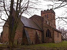
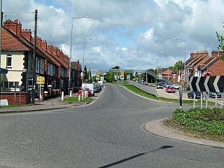
Curdworth is a village and civil parish in the North Warwickshire district of the county of Warwickshire in England. The population taken at the 2011 census was 1,115.
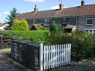
Oldland Common is a village in the far south region of South Gloucestershire, England, on the outskirts of Bristol. It is in the civil parish of Bitton, approximately 8 miles between the centres of cities Bristol and Bath.

Stoneleigh is a small village in Warwickshire, England, on the River Sowe, situated 4.5 miles (7.25 km) south of Coventry and 5.5 miles (9 km) north of Leamington Spa. The population taken at the 2011 census was 3,636. The village is about 600 yards (549 m) northeast of the confluence of the River Sowe and the River Avon. The village's church is dedicated to the Virgin Mary. Stoneleigh has no public house: all three were closed by Lord Leigh more than 100 years ago, after his daughter was laughed at by drunks when she was going to church on a tricycle. However it has a social club, which meets in the evenings on Vicarage Road.

Baxterley is a small village and civil parish in the North Warwickshire district of Warwickshire in England. According to the 2001 Census, it had a population of 335, reducing to 328 at the 2011 Census. The village is about two miles west of Atherstone and is home to Jaguar Land Rover's national distribution centre.
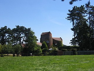
Blackdown is a hamlet and civil parish in the Warwick district of Warwickshire, England. Blackdown is about two miles north of Leamington Spa, between Leamington/Warwick and Kenilworth. It is named Blakedon in William Dudgale's Antiquities of Warwickshire in 1656 as a district within the parish of Lillington, and as having a mill on the River Avon. Blackdown Mill on Wooton Road is Grade II listed. According to the 2001 Census it had a population of 128. From the 2011 Census population details are included with Old Milverton. Blackdown Manor is a Grade II listed house on Kenilworth Road: built in the 17th century, it was remodelled in the 19th century. Just outside the village is Quarry Park Disc Golf Club which is one of only 17 courses in the United Kingdom, and was the venue for the 2008 UK championships as well as being due to host the 2009 championships. Old Leamingtonians, the town's rugby union and Leamington Royals also play home games on the edge of the village.
Hucking is a small hamlet and civil parish in the Maidstone District of Kent, England. It is located 4 miles (6.4 km) north-east of Maidstone and 5 miles (8.0 km) south-west of Sittingbourne. The parish is governed by a parish meeting.
Craigneuk is a suburb of Wishaw, North Lanarkshire, Scotland. The original village of Craigneuk was located in the area where Meadowhead Road meets the A721 at Craigneuk Street. It was originally part of Dalziel parish, along with the other rural weaving villages of Flemington, Motherwell and Windmillhill. Craigneuk village was located close to the boundary with Cambusnethan parish.
Rowington is a village and civil parish in the English county of Warwickshire. It is five miles north-west of the town of Warwick and five miles south-west of the town of Kenilworth. The parish, which also includes Lowsonford, Pinley and Mousley End, had a population of 925 according to the 2001 UK Census, increasing to 944 at the 2011 Census. The Grand Union Canal runs just south of the village and the M40 motorway is also close by. The Heart of England Way for long-distance walkers passes through the village. The parish church of St. Laurence which dates from medieval times is found on a hill in the centre of the village. In the Tudor era Rowington manor was owned by Queen Catherine Parr.
Luddington is a small village and civil parish in the English county of Warwickshire. The population in 2001 was 457, increasing to 475 at the 2011 Census. It is located about 5 kilometres outside the town of Stratford-upon-Avon on the banks of the river Avon and has views south over the Cotswolds. Facilities and communications include a phone box, a 19th-century church, a post box, a marina with a 17th-century lock, a village green and a recently refurbished village hall originally built in 1953. The parish encompasses Dodwell Caravan Park to the north of the village. The village is reputed to be the meeting place of Anne Hathaway and William Shakespeare, as Anne was from the parish, and local lore states that they probably conducted their courtship in the area.
Dordon is a village and civil parish in the North Warwickshire district of the county of Warwickshire in England and close to the border with Staffordshire. The village is located on the A5 national route and is contiguous with the larger village of Polesworth. Other nearby places include Tamworth, Atherstone, Grendon, Wood End Village, Baddesley Ensor and Nuneaton. In 2001 the population for the parish of Dordon was 3,225, reducing slightly to 3,215 at the 2011 census.

Merevale is a small village and civil parish in the North Warwickshire district of the county of Warwickshire in England. Located about one and a half miles west of Atherstone, it is the site of a medieval Cistercian Abbey and Merevale Hall.

Titsey is a rural village and a civil parish on the North Downs almost wholly within the M25 London Orbital Motorway in the Tandridge District of Surrey, England.

Moreton Morrell is a village and civil parish in the county of Warwickshire, England. It is part of the historic hundred of Kington and is located about three and a half miles north west of the village of Kineton. The settlement was first mentioned in the Domesday Book as Moreton. From at least Norman times, it has consisted of the village of Moreton and the hamlet of Morrell. The parish of Moreton Morrell is bounded on the east and south east by the Fosse Way, and consists of Little Morrell in the north, the village of Moreton Morrell, and Moreton Paddox in the south.

Ufton is a small village and civil parish in the Stratford-on-Avon District of Warwickshire, England. The population taken from the 2011 census was 319. It is 5 miles (8 km) south east of Royal Leamington Spa and 2 miles (3 km) west of Southam on the A425 road. It sits on top of a glacial escarpment 121 metres above sea level, which was formed during the last ice age. Ufton Fields, a 77-acre (31 ha) Site of Special Scientific Interest, is to the south east of the village. The parish church, which is dedicated to St Michael, dates back at least to the start of the 13th century. The Grand Union Canal is within walking distance of the village to the north.

Ratley is a village in the civil parish of Ratley and Upton, Stratford-on-Avon District, Warwickshire, England. The population of the civil parish in 2011 was 327. It is on the northwest side of the Edge Hill escarpment about 200 metres (660 ft) above sea level. The village is close to the county border with north Oxfordshire, some 7 miles northwest of Banbury, the closest town.