Castile or Castille is a territory of imprecise limits located in Spain. The use of the concept of Castile relies on the assimilation of a 19th-century determinist geographical notion, that of Castile as Spain's centro mesetario with a long-gone historical entity of diachronically variable territorial extension.

Valladolid is a municipality in Spain and the primary seat of government and de facto capital of the autonomous community of Castile and León. It is also the capital of the province of Valladolid. It has a population of 295,639 people.

Castile and León is an autonomous community in northwestern Spain. It was created in 1983 by the merging of the provinces of the historic region of León: León, Zamora and Salamanca with those of Old Castile : Ávila, Burgos, Palencia, Segovia, Soria and Valladolid. The provinces of Santander and Logroño, which until then had been included in the Old Castile administrative division, opted out of this merger and formed the new Autonomous Communities of Cantabria and La Rioja respectively.

Salamanca is a province of western Spain, in the western part of the autonomous community of Castile and León. It is bordered by the provinces of Zamora, Valladolid, Ávila, and Cáceres, and on the west by Portugal. It has an area of 12,349 km2 and in 2018 had a population of 331,473 people. It is divided into 362 municipalities, 11 comarcas, 32 mancomunidades and five judicial districts. Of the 362 municipalities, more than half are villages with fewer than 300 people.

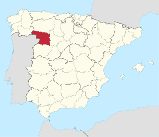
Valladolid is a province of northwest Spain, in the central part of the autonomous community of Castile and León. It has a population of 520,716 people in a total of 225 municipalities, an area of 8,110 km2 (3,130 sq mi) and a population density of 64.19 people per km2.
Zamora is a province of western Spain, in the western part of the autonomous community of Castile and León. It is bordered by the provinces of Ourense, León, Valladolid, and Salamanca, and by Portugal.

Zamora is a city and municipality of Spain located in the autonomous community of Castile and León. It is the capital of the province of Zamora. The city straddles the Duero river. With its 24 characteristic Romanesque style churches of the 12th and 13th centuries it has been called a "museum of Romanesque art". Zamora is the city with the most Romanesque churches in all of Europe. The most important celebration in Zamora is the Holy Week.

Castilian-Leonese cuisine refers to the typical dishes and ingredients of the region of Castile and León in Spain. This cuisine is known for its cooked dishes (guiso) and its grilled or roasted meats (asado), its high-quality wines, the variety of its desserts, its sausages (embutidos), and its cheeses.

Puertollano is a municipality of Spain located in the province of Ciudad Real, Castile-La Mancha. The city has a population of 45,539 (2022). Contrasting to the largely rural character of the region, Puertollano stands out for the importance of industry, with a past linked to industrial and mining activities. It lies on the AVE high-speed train line linking Madrid and Seville.
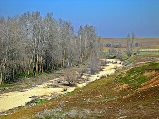
The Trabancos is a river in Spain that flows between the Zapardiel and the Guareña rivers, and is a tributary of the Duero river. The source of the Trabancos is in Moraña, a region in the north of the province of Ávila, near Blascomillán. The Trabancos is at an elevation of approximately 1,100 metres (3,600 ft), is approximately 85 kilometres (53 mi) long and, although its river bed is stable, only has a constant water flow during and immediately after torrential rains.

Baltanás is a municipality located in the province of Palencia, Castile and León, Spain. According to the 2021 census (INE), the municipality had a population of 1,219 inhabitants.

Samir de los Caños is a municipality in the province of Zamora, Castile and León, Spain. According to the 2004 census (INE), the municipality has a population of 227 inhabitants. As of 2022, Samir de los Caños had 163 inhabitants.

Almazán is a municipality located in the province of Soria, Castile and León, Spain. As of 2013, the municipality has a population of 5,843 inhabitants. It is also the seat of the judicial district of Almazán, and ecclesiastically it belongs to the Diocese of Osma, a suffragan diocese of the Archdiocese of Burgos. Connected via the Autovía A-15 and Carretera nacional N-111, it is situated 194 kilometres (121 mi) by road northeast of Madrid. The town lies on the east bank of the Duero river.
Laguna de Duero is a municipality located in the province of Valladolid, Castile and León, Spain. According to the 2016 census (INE), the municipality has a population of 22 ,696 inhabitants.
Julio Valdeón Baruque was a historian of Spain.
Boroña is a type of bread made with corn in northern Spain. This cornbread is a bread made with cornmeal. It is a traditional food from the regions of Galicia, Asturias, Cantabria, the Basque Country and northern Castilla-Leon, Spain. It has been widely used in rural areas until the mid twentieth century. It is usually cooked in an oven wrapped in cabbage leaves.

Hotel Abadía Retuerta LeDomaine, the former Monastery of Santa María de Retuerta, is located on the left bank of the river Duero, near the town of Sardón de Duero, in the province of Valladolid, autonomous community of Castile and León, Spain. The monastery belonged to the Premonstratensians and was built during the period of 1146 through the 15th century in late-Romanesque style. It was founded by Sancho Ansúrez, grandson of Count Pedro Ansúrez. The building was declared a Monumento Histórico-Artístico of national interest on June 3, 1931, and then a Bien de Interés Cultural. More recently, it has been transformed into a hotel, and belongs to the privately owned business group Novartis. In 2016, it was awarded as the best tourist hotel by Fitur.

Ojo Guareña is a karst complex located in the Cantabrian Mountains of Castile and Leon, Spain, declared a natural monument by the government of Castile and Leon in 1996. It is composed of over 90 kilometres (56 mi) of galleries and passages within an area of some 13,850 hectares. The limestone formation containing the system is approximately 100 metres (330 ft) thick and sits on a massive water-resistant layer of marl. The caves were formed in the limestone by erosion sometime within the Coniacian Age. Ojo Guareña was considered the greatest karst system of the Iberian Peninsula until 2009, when a significant length of new passages was discovered in the Mortillano system.

The topographical relief of Spain is characterized by being quite high, with an average altitude of 660 meters above sea level, quite mountainous compared to other European countries and only surpassed by Switzerland, Austria, Greece and the microstates of Andorra and Liechtenstein. In peninsular Spain, the terrain is articulated around a large Meseta Central that occupies most of the center of the Iberian Peninsula. Outside the plateau, there is the depression of the Guadalquivir river, located in the southwest of the peninsula, and the Ebro river depression, located in the northeast.
The history of the territorial organization of Spain, in the modern sense, is a process that began in the 16th century with the dynastic union of the Crown of Aragon and the Crown of Castile, the conquest of the Kingdom of Granada and later the Kingdom of Navarre. However, it is important to clarify the origin of the toponym Spain, as well as the territorial divisions that existed previously in the current Spanish territory.


