Gmina Jedlicze is an urban-rural gmina in Krosno County, Subcarpathian Voivodeship, in south-eastern Poland. Its seat is the town of Jedlicze, which lies approximately 9 kilometres (6 mi) north-west of Krosno and 44 km (27 mi) south-west of the regional capital Rzeszów.
Gmina Korczyna is a rural gmina in Krosno County, Subcarpathian Voivodeship, in south-eastern Poland. Its seat is the village of Korczyna, which lies approximately 7 kilometres (4 mi) north-east of Krosno and 38 km (24 mi) south of the regional capital Rzeszów.
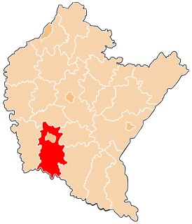
Gmina Wojaszówka is a rural gmina in Krosno County, Subcarpathian Voivodeship, in south-eastern Poland. Its seat is the village of Wojaszówka, which lies approximately 13 kilometres (8 mi) north-west of Krosno and 37 km (23 mi) south-west of the regional capital Rzeszów.

Czarnorzeki-Strzyżów Landscape Park is a protected area in south-eastern Poland, established in 1993, covering an area of 257.84 square kilometres (99.55 sq mi).

Szczepańcowa is a village in the administrative district of Gmina Chorkówka, within Krosno County, Subcarpathian Voivodeship, in south-eastern Poland. It lies approximately 4 kilometres (2 mi) north of Chorkówka, 4 km (2 mi) west of Krosno, and 45 km (28 mi) south-west of the regional capital Rzeszów.

Chyrowa is a village in the administrative district of Gmina Dukla, within Krosno County, Subcarpathian Voivodeship, in south-eastern Poland, close to the border with Slovakia. It lies approximately 6 kilometres (4 mi) south-west of Dukla, 19 km (12 mi) south-west of Krosno, and 62 km (39 mi) south-west of the regional capital Rzeszów.
Teodorówka is a village in the administrative district of Gmina Dukla, within Krosno County, Subcarpathian Voivodeship, in south-eastern Poland, close to the border with Slovakia. It lies approximately 3 kilometres (2 mi) south-west of Dukla, 17 km (11 mi) south-west of Krosno, and 60 km (37 mi) south-west of the regional capital Rzeszów.
Podniebyle is a village in the administrative district of Gmina Jedlicze, within Krosno County, Subcarpathian Voivodeship, in south-eastern Poland. It lies approximately 5 kilometres (3 mi) south-west of Jedlicze, 10 km (6 mi) west of Krosno, and 48 km (30 mi) south-west of the regional capital Rzeszów.
Miejsce Piastowe is a village in Krosno County, Subcarpathian Voivodeship, in south-eastern Poland. It is the seat of the gmina called Gmina Miejsce Piastowe. It lies approximately 7 kilometres (4 mi) south-east of Krosno and 48 km (30 mi) south of the regional capital Rzeszów.
Bajdy is a village in the administrative district of Gmina Wojaszówka, within Krosno County, Subcarpathian Voivodeship, in south-eastern Poland. It lies approximately 3 kilometres (2 mi) south-west of Wojaszówka, 12 km (7 mi) north-west of Krosno, and 39 km (24 mi) south-west of the regional capital Rzeszów.
Bratkówka is a village in the administrative district of Gmina Wojaszówka, within Krosno County, Subcarpathian Voivodeship, in south-eastern Poland. It lies approximately 4 kilometres (2 mi) south-east of Wojaszówka, 10 km (6 mi) north of Krosno, and 37 km (23 mi) south-west of the regional capital Rzeszów.
Łączki Jagiellońskie is a village in the administrative district of Gmina Wojaszówka, within Krosno County, Subcarpathian Voivodeship, in south-eastern Poland. It lies approximately 3 kilometres (2 mi) north-east of Wojaszówka, 14 km (9 mi) north of Krosno, and 34 km (21 mi) south-west of the regional capital Rzeszów.
Łęki Strzyżowskie is a village in the administrative district of Gmina Wojaszówka, within Krosno County, Subcarpathian Voivodeship, in south-eastern Poland.
Odrzykoń is a village in the administrative district of Gmina Wojaszówka, within Krosno County, Subcarpathian Voivodeship, in south-eastern Poland. It lies approximately 7 kilometres (4 mi) south-east of Wojaszówka, 8 km (5 mi) north of Krosno, and 37 km (23 mi) south-west of the regional capital Rzeszów.
Pietrusza Wola is a village in the administrative district of Gmina Wojaszówka, within Krosno County, Subcarpathian Voivodeship, in south-eastern Poland. It lies approximately 4 kilometres (2 mi) north of Wojaszówka, 16 km (10 mi) north of Krosno, and 34 km (21 mi) south-west of the regional capital Rzeszów. Its approximate population is 300.
Przybówka is a village in the administrative district of Gmina Wojaszówka, within Krosno County, Subcarpathian Voivodeship, in south-eastern Poland. It lies approximately 3 kilometres (2 mi) west of Wojaszówka, 15 km (9 mi) north-west of Krosno, and 38 km (24 mi) south-west of the regional capital Rzeszów. The village has a population of 830.
Rzepnik is a village in the administrative district of Gmina Wojaszówka, within Krosno County, Subcarpathian Voivodeship, in south-eastern Poland. It lies approximately 6 kilometres (4 mi) east of Wojaszówka, 13 km (8 mi) north of Krosno, and 32 km (20 mi) south-west of the regional capital Rzeszów.
Ustrobna is a village in the administrative district of Gmina Wojaszówka, within Krosno County, Subcarpathian Voivodeship, in south-eastern Poland. It lies approximately 4 kilometres (2 mi) south of Wojaszówka, 9 km (6 mi) north-west of Krosno, and 39 km (24 mi) south-west of the regional capital Rzeszów.
Wojkówka is a village in the administrative district of Gmina Wojaszówka, within Krosno County, Subcarpathian Voivodeship, in south-eastern Poland. It lies approximately 2 kilometres (1 mi) east of Wojaszówka, 12 km (7 mi) north of Krosno, and 36 km (22 mi) south-west of the regional capital Rzeszów.
Kujawa is a village in the administrative district of Gmina Gubin, within Krosno Odrzańskie County, Lubusz Voivodeship, in western Poland, close to the German border. It lies approximately 8 kilometres (5 mi) south-east of Gubin, 27 km (17 mi) south-west of Krosno Odrzańskie, and 50 km (31 mi) west of Zielona Góra.