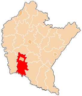
Gmina Krościenko Wyżne is a rural gmina in Krosno County, Subcarpathian Voivodeship, in south-eastern Poland. Its seat is the village of Krościenko Wyżne, which lies approximately 5 kilometres (3 mi) east of Krosno and 42 km (26 mi) south of the regional capital Rzeszów.

Czarnorzeki-Strzyżów Landscape Park is a protected area in south-eastern Poland, established in 1993, covering an area of 257.84 square kilometres (99.55 sq mi).

Korczyna is a village in the administrative district of Gmina Biecz, within Gorlice County, Lesser Poland Voivodeship, in southern Poland. It lies approximately 4 kilometres (2 mi) south of Biecz, 9 km (6 mi) north-east of Gorlice, and 103 km (64 mi) south-east of the regional capital Kraków.
Cergowa is a village in the administrative district of Gmina Dukla, within Krosno County, Subcarpathian Voivodeship, in south-eastern Poland, close to the border with Slovakia. It lies approximately 3 kilometres (2 mi) south-east of Dukla, 16 km (10 mi) south of Krosno, and 58 km (36 mi) south of the regional capital Rzeszów.
Równe is a village in the administrative district of Gmina Dukla, within Krosno County, Subcarpathian Voivodeship, in south-eastern Poland, close to the border with Slovakia. It lies approximately 5 kilometres (3 mi) north-east of Dukla, 11 km (7 mi) south of Krosno, and 53 km (33 mi) south-west of the regional capital Rzeszów.
Wietrzno is a village in the administrative district of Gmina Dukla, within Krosno County, Subcarpathian Voivodeship, in south-eastern Poland, close to the border with Slovakia. It lies approximately 5 kilometres (3 mi) north-east of Dukla, 10 km (6 mi) south of Krosno, and 53 km (33 mi) south-west of the regional capital Rzeszów.
Zawadka Rymanowska is a village in the administrative district of Gmina Dukla, within Krosno County, Subcarpathian Voivodeship, in south-eastern Poland, close to the border with Slovakia. It lies approximately 7 kilometres (4 mi) south-east of Dukla, 19 km (12 mi) south of Krosno, and 61 km (38 mi) south of the regional capital Rzeszów.
Zboiska is a village in the administrative district of Gmina Dukla, within Krosno County, Subcarpathian Voivodeship, in south-eastern Poland, close to the border with Slovakia. It lies approximately 1 kilometre (1 mi) north-east of Dukla, 14 km (9 mi) south of Krosno, and 57 km (35 mi) south-west of the regional capital Rzeszów.
Czarnorzeki is a village in the administrative district of Gmina Korczyna, within Krosno County, Subcarpathian Voivodeship, in south-eastern Poland. It lies approximately 4 kilometres (2 mi) north of Korczyna, 9 km (6 mi) north-east of Krosno, and 35 km (22 mi) south-west of the regional capital Rzeszów.
Iskrzynia is a village in the administrative district of Gmina Korczyna, within Krosno County, Subcarpathian Voivodeship, in south-eastern Poland. It lies approximately 5 kilometres (3 mi) south-east of Korczyna, 8 km (5 mi) east of Krosno, and 41 km (25 mi) south of the regional capital Rzeszów.

Kombornia is a village in the administrative district of Gmina Korczyna, within Krosno County, Subcarpathian Voivodeship, in south-eastern Poland. It lies approximately 5 kilometres (3 mi) east of Korczyna, 10 km (6 mi) east of Krosno, and 37 km (23 mi) south of the regional capital Rzeszów.

Korczyna is a village in Krosno County, Subcarpathian Voivodeship, in south-eastern Poland. It is the seat of the gmina called Gmina Korczyna. It lies approximately 7 kilometres (4 mi) north-east of Krosno and 38 km (24 mi) south of the regional capital Rzeszów.
Krasna is a village in the administrative district of Gmina Korczyna, within Krosno County, Subcarpathian Voivodeship, in south-eastern Poland. It lies approximately 8 kilometres (5 mi) north of Korczyna, 14 km (9 mi) north-east of Krosno, and 30 km (19 mi) south of the regional capital Rzeszów.
Węglówka is a village in the administrative district of Gmina Korczyna, within Krosno County, Subcarpathian Voivodeship, in south-eastern Poland. It lies approximately 8 kilometres (5 mi) north-west of Korczyna, 11 km (7 mi) north of Krosno, and 33 km (21 mi) south-west of the regional capital Rzeszów.
Bzianka is a village in the administrative district of Gmina Rymanów, within Krosno County, Subcarpathian Voivodeship, in south-eastern Poland. It lies approximately 9 kilometres (6 mi) north-east of Rymanów, 15 km (9 mi) south-east of Krosno, and 45 km (28 mi) south of the regional capital Rzeszów.

Klimkówka is a village in the administrative district of Gmina Rymanów, within Krosno County, Subcarpathian Voivodeship, in south-eastern Poland. It lies approximately 5 kilometres (3 mi) north-west of Rymanów, 13 km (8 mi) south-east of Krosno, and 52 km (32 mi) south of the regional capital Rzeszów.
Łazy is a village in the administrative district of Gmina Rymanów, within Krosno County, Subcarpathian Voivodeship, in south-eastern Poland. It lies approximately 3 kilometres (2 mi) north-east of Rymanów, 16 km (10 mi) south-east of Krosno, and 51 km (32 mi) south of the regional capital Rzeszów.

Milcza is a village in the administrative district of Gmina Rymanów, within Krosno County, Subcarpathian Voivodeship, in south-eastern Poland. It lies approximately 7 kilometres (4 mi) north-east of Rymanów, 15 km (9 mi) south-east of Krosno, and 47 km (29 mi) south of the regional capital Rzeszów.

Sieniawa is a village in the administrative district of Gmina Rymanów, within Krosno County, Podkarpackie Province, in south-eastern Poland. It lies approximately 4 kilometres (2 mi) south-east of Rymanów, 20 km (12 mi) south-east of Krosno, and 54 km (34 mi) south of the regional capital Rzeszów.