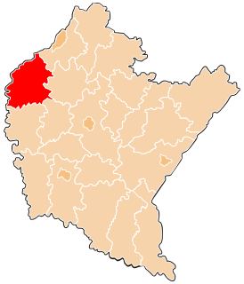
Tuszów Narodowy is a village in Mielec County, Subcarpathian Voivodeship, in south-eastern Poland. It is the seat of the gmina called Gmina Tuszów Narodowy. It lies approximately 10 kilometres (6 mi) north of Mielec and 54 km (34 mi) north-west of the regional capital Rzeszów.
Górki is a village in the administrative district of Gmina Borowa, within Mielec County, Subcarpathian Voivodeship, in south-eastern Poland. It lies approximately 7 kilometres (4 mi) west of Borowa, 16 km (10 mi) north-west of Mielec, and 65 km (40 mi) north-west of the regional capital Rzeszów.
Łysakówek is a village in the administrative district of Gmina Borowa, within Mielec County, Subcarpathian Voivodeship, in south-eastern Poland. It lies approximately 5 kilometres (3 mi) south-west of Borowa, 14 km (9 mi) north-west of Mielec, and 63 km (39 mi) north-west of the regional capital Rzeszów.
Pławo is a village in the administrative district of Gmina Borowa, within Mielec County, Subcarpathian Voivodeship, in south-eastern Poland. It lies approximately 3 kilometres (2 mi) south of Borowa, 11 km (7 mi) north-west of Mielec, and 59 km (37 mi) north-west of the regional capital Rzeszów.
Surowa is a village in the administrative district of Gmina Borowa, within Mielec County, Subcarpathian Voivodeship, in south-eastern Poland. It lies approximately 8 kilometres (5 mi) west of Borowa, 16 km (10 mi) north-west of Mielec, and 66 km (41 mi) north-west of the regional capital Rzeszów.
Wola Pławska is a village in the administrative district of Gmina Borowa, within Mielec County, Subcarpathian Voivodeship, in south-eastern Poland. It lies approximately 6 kilometres (4 mi) south of Borowa, 8 km (5 mi) north-west of Mielec, and 57 km (35 mi) north-west of the regional capital Rzeszów.
Brzyście is a village in the administrative district of Gmina Gawłuszowice, within Mielec County, Subcarpathian Voivodeship, in south-eastern Poland. It lies approximately 6 kilometres (4 mi) south of Gawłuszowice, 10 km (6 mi) north of Mielec, and 57 km (35 mi) north-west of the regional capital Rzeszów.
Boża Wola is a village in the administrative district of Gmina Mielec, within Mielec County, Subcarpathian Voivodeship, in south-eastern Poland. It lies approximately 4 kilometres (2 mi) south of Mielec and 48 km (30 mi) north-west of the regional capital Rzeszów.
Chrząstów is a village in the administrative district of Gmina Mielec, within Mielec County, Subcarpathian Voivodeship, in south-eastern Poland. It lies approximately 8 kilometres (5 mi) north of Mielec and 56 km (35 mi) north-west of the regional capital Rzeszów.
Książnice is a village in the administrative district of Gmina Mielec, within Mielec County, Subcarpathian Voivodeship, in south-eastern Poland. It lies approximately 4 kilometres (2 mi) south of Mielec and 49 km (30 mi) north-west of the regional capital Rzeszów.
Rzędzianowice is a village in the administrative district of Gmina Mielec, within Mielec County, Subcarpathian Voivodeship, in south-eastern Poland. It lies approximately 5 kilometres (3 mi) north-west of Mielec and 54 km (34 mi) north-west of the regional capital Rzeszów.
Wola Chorzelowska is a village in the administrative district of Gmina Mielec, within Mielec County, Subcarpathian Voivodeship, in south-eastern Poland. It lies approximately 7 kilometres (4 mi) north-east of Mielec and 47 km (29 mi) north-west of the regional capital Rzeszów.
Wola Mielecka is a village in the administrative district of Gmina Mielec, within Mielec County, Subcarpathian Voivodeship, in south-eastern Poland. It lies approximately 5 kilometres (3 mi) west of Mielec and 54 km (34 mi) north-west of the regional capital Rzeszów.
Złotniki is a village in the administrative district of Gmina Mielec, within Mielec County, Subcarpathian Voivodeship, in south-eastern Poland. It lies approximately 5 kilometres (3 mi) north-west of Mielec and 54 km (34 mi) north-west of the regional capital Rzeszów.
Babicha is a village in the administrative district of Gmina Tuszów Narodowy, within Mielec County, Subcarpathian Voivodeship, in south-eastern Poland. It lies approximately 4 kilometres (2 mi) north-west of Tuszów Narodowy, 12 km (7 mi) north of Mielec, and 57 km (35 mi) north-west of the regional capital Rzeszów.
Izbiska is a village in the administrative district of Gmina Wadowice Górne, within Mielec County, Subcarpathian Voivodeship, in south-eastern Poland. It lies approximately 5 kilometres (3 mi) south-west of Wadowice Górne, 15 km (9 mi) south-west of Mielec, and 59 km (37 mi) west of the regional capital Rzeszów.
Kawęczyn is a village in the administrative district of Gmina Wadowice Górne, within Mielec County, Subcarpathian Voivodeship, in south-eastern Poland. It lies approximately 4 kilometres (2 mi) north of Wadowice Górne, 12 km (7 mi) west of Mielec, and 61 km (38 mi) north-west of the regional capital Rzeszów.
Wadowice Dolne is a village in the administrative district of Gmina Wadowice Górne, within Mielec County, Subcarpathian Voivodeship, in south-eastern Poland. It lies approximately 4 kilometres (2 mi) north-west of Wadowice Górne, 14 km (9 mi) west of Mielec, and 61 km (38 mi) north-west of the regional capital Rzeszów.
Zabrnie is a village in the administrative district of Gmina Wadowice Górne, within Mielec County, Subcarpathian Voivodeship, in south-eastern Poland. It lies approximately 7 kilometres (4 mi) north-west of Wadowice Górne, 17 km (11 mi) west of Mielec, and 65 km (40 mi) north-west of the regional capital Rzeszów.
Tuszów Mały is a village in the administrative district of Gmina Tuszów Narodowy, within Mielec County, Subcarpathian Voivodeship, in south-eastern Poland. It lies approximately 3 kilometres (2 mi) south-west of Tuszów Narodowy, 8 km (5 mi) north of Mielec, and 53 km (33 mi) north-west of the regional capital Rzeszów.