The Central or Midtown section of Norwalk, Connecticut is an urbanized area in roughly the geographic center of the city, north of the South Norwalk neighborhood and the Connecticut Turnpike. Wall Street, West Avenue and Belden Avenue are the main thoroughfares. It has also been called "Norwalk Center" or "Downtown Norwalk".

The Black Rock Historic District is a predominantly residential historic district in the Black Rock section of Bridgeport, Connecticut. It was listed on the National Register of Historic Places in 1979. At that time it included 109 contributing buildings. The historic district surrounds at the upper reaches of Black Rock Harbor.

The Worthington Ridge Historic District encompasses the historic town center of Berlin, Connecticut. It runs mostly along Worthington Ridge Road from the intersection of Mill Street to Sunset Lane. This section of road was historically part of the Boston Post Road laid out in 1673, and is now lined by a diversity of residential architecture and several of the town's civic buildings. In 1974, the Berlin Historic District was formed in order to preserve the integrity of the architecture of the village. The district was listed on the National Register of Historic Places in 1989.

The Lunenburg Historic District is a historic district encompassing the historic center of Lunenburg, Massachusetts. The district is centered on a stretch of Main Street which connects two triangular intersections. It includes many of the town's oldest buildings, including the c. 1724 Cushing House, and the c. 1730 Stillman Stone House. Three of the town's most significant institutional buildings were built before 1850: the town hall, the Congregational church, and the Methodist church. The district was added to the National Register of Historic Places in 1988.

The Colchester Village Historic District encompasses most of the historic village center of Colchester, Connecticut. It is located at the junction of Route 16, Route 85, and Norwich Avenue. Roughly, the district extends to the northwest along Broadway Street as far as Jaffe Terrace; east along Norwich Avenue to just short of Pleasant Street; south along South Main Street to just north of Hall Hill Road; west along Linwood Avenue to just east of Kmick Lane. The historic district was listed on the National Register of Historic Places (NRHP) in 1994.

Columbia Green Historic District is a historic district that includes the town green, Columbia Green, of the town of Columbia, Connecticut, United States. The district includes buildings around the green and extending northwest along Route 87. The district was listed on the National Register of Historic Places in 1990. It comprises 43 buildings, 2 sites, and 1 object that contribute to the historical significance of the area.

Norwichtown is a historic neighborhood in the city of Norwich, Connecticut. It is generally the area immediately north of the Yantic River between I-395 and Route 169.

Newington Junction is a section of the town of Newington, Connecticut. It is centered at the intersection of Willard Avenue and West Hill Road in the northwestern part of the town, in the area generally just south of the Hartford city line. The name of the area refers to the railroad junction where the railroad line from New Haven meets with the railroad line from Bristol and Waterbury. The development of Newington Junction as a result of the railroad was instrumental in the separation of the town of Newington from its mother town of Wethersfield.

The Union Green is the town green of the New England town of Union, Connecticut. The Green is a small town-owned wedge at the north end of a triangle park area formed by Town Hall Road, Buckley Highway and Kinney Hollow Road. The Green, Union Grove, and properties to the north along Route 190 are listed on the National Register of Historic Places as the Union Green Historic District. The historic district contains 16 buildings, 3 sites, and 2 objects over an area of 300 acres (1.2 km2).
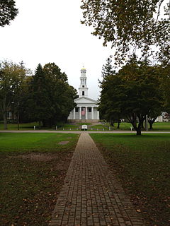
Madison Green is the town green of the New England town of Madison, Connecticut. The green is the centerpiece of the Madison Green Historic District, and is located just west of the commercial strip of Madison on United States Route 1. The green is bounded on the south by US 1, Meeting House Lane on the east and north, and Copse Road on the west. Surrounding the green are several buildings, most prominent being the First Congregational Church. Other buildings around the green include Memorial Hall (1896), a community meeting building, Academy Elementary School (1884), and Lee Academy (1821).
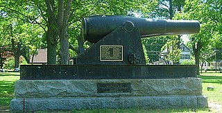
The East Haven Green is the town green of the New England town of East Haven, Connecticut. It is bounded by River Street, Hemingway Avenue, Main Street, and Park Place and is the focal point of the East Haven Green Historic District, listed on the National Register of Historic Places. This area is also part of the commercial business district of the town and contains many two- and three-story brick office buildings that have been constructed within the last ten or fifteen years. Farther to the northwest are a shopping center and high-rise apartment buildings.

West Haven Green is the town green of the New England town of West Haven, Connecticut. The green is bordered by Church Street on the south, Savin Avenue on the west, Main Street on the north and Campbell Avenue on the east. The green and surrounding buildings are part of the West Haven Green Historic District.
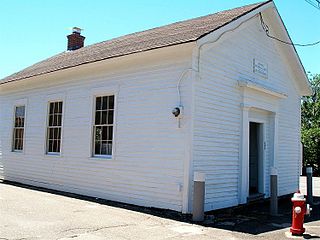
Prospect Green Historic District is a historic district in the New England town of Prospect, Connecticut. The district is centered on the Prospect Green, the town green. The green is located on the highest settled point in New Haven County. The green is bounded by Route 68 and Center and Church Streets.

The Bean Hill Historic District is a historic district in Norwich, Connecticut that was listed on the National Register of Historic Places in 1982. It consists of a well-preserved collection of buildings focused on the Bean Hill Green, which capture the 19th-century period when Bean Hill was a local center for manufacturing and commercial activity. The district is located in the vicinity of West Town Street between I-395 and Connecticut Avenue, and also extends northeast along Huntington Avenue to include properties further beyond Bean Hill Plain. The district is about 22 acres (8.9 ha) in size, with 23 contributing buildings.

The Lebanon Green Historic District encompasses the historic town center of Lebanon, Connecticut. It extends along the nearly mile-long town green, including historic buildings that face it, as well as a few on nearby streets. The green is bounded on its north by Connecticut Route 87 and on the south by West Town Street, and extends from a junction with Connecticut Route 289 to a triangular point south of Connecticut Route 207. The district includes a number of prominent civic and religious buildings, including the town hall, library, and Congregational church, although these are all 20th century buildings. Prominent buildings including the National Historic Landmark John Trumbull Birthplace and William Williams House, and the 1730 War Office. The district was listed on the National Register of Historic Places in 1979. The Alden Tavern Site is a contributing property.

The Greenwich Avenue Historic District is a historic district representing the commercial and civic historical development of the downtown area of the town of Greenwich, Connecticut. The district was listed on the National Register of Historic Places on August 31, 1989. Included in the district is the Greenwich Municipal Center Historic District, which was listed on the National Register the year before for the classical revival style municipal buildings in the core of Downtown. Most of the commercial buildings in the district fall into three broad styles, reflecting the period in which they were built: Italianate, Georgian Revival, and Commercial style. The district is linear and runs north–south along the entire length of Greenwich Avenue, the main thoroughfare of Downtown Greenwich, between U.S. Route 1 and the New Haven Line railroad tracks.
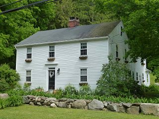
The Canton Center Historic District encompasses the historic rural town center of Canton, Connecticut. Extending mainly along Connecticut Route 179, near the geographic town center, is a well-preserved example of a rural agricultural center in Connecticut, a role served until about 1920. The district includes many examples of Late Victorian and Greek Revival architecture. It was listed on the National Register of Historic Places in 1997.

The Watertown Center Historic District encompasses the historic village center of Watertown, Connecticut. It exhibits architectural and historic changes from the early 1700s into the 20th century. It is roughly bounded by Main, Warren, North, Woodbury, Woodruff, and Academy Hill Roads, and was listed on the National Register of Historic Places in 2001.
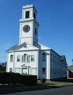
The Rocky Hill Center Historic District encompasses the traditional town center and surrounding residential area of Rocky Hill, Connecticut. It extends along Old Main Street from the Wethersfield line southward to a triangular area bounded by Old Main, Riverview Road, and Glastonbury Avenue. Included in a basically 19th-century streetscape are the town's principal civic and religious buildings, as well as a fine collection of mainly 18th and 19th-century residential architecture. The district was listed on the National Register of Historic Places in 2007.
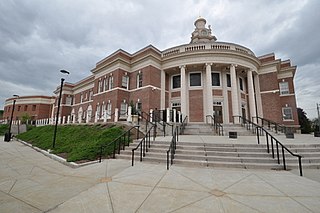
Centerville, originally spelled Centreville, is a neighborhood in the east-central portion of the town of Hamden, Connecticut. It is the location of Hamden Town Hall and other major town government buildings. It derived its name from being at the intersection of the town's two principal thoroughfares, Whitney and Dixwell avenues, both with commercial development. The rest of the neighborhood is residential, with single-family houses, condominiums, and apartments.



